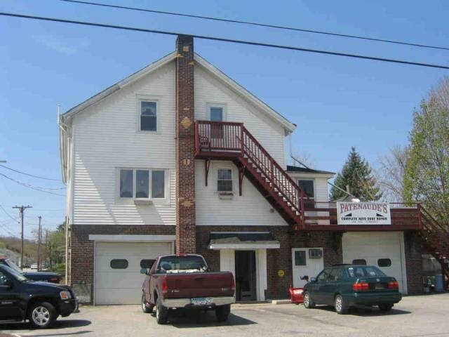
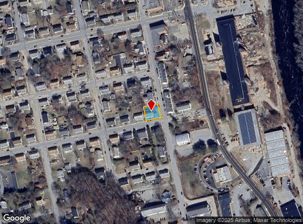
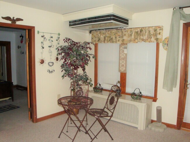
Property Record
10 S B St, Taftville, CT 06380
NEARBY LISTINGS FOR SALE OR LEASE
Property Detail
10 S B St
NORW-000047-000001-000065
New London
Commercialbuilding
Connecticut
X
65
09011C0208G
0.16 AC
2024
NE New London/Norwich
2025
Hartford
696100
Norwich-New London, CT
1,739 SF
DEMOGRAPHICS near 10 S B St
1 Mile
3 Mile
5 Mile
2024 Total Population
4,807
21,467
49,798
2029 Population
4,783
21,293
49,668
Pop Growth 2024-2029
(0.50%)
(0.81%)
(0.26%)
Average Age
40
40
40
2024 Total Households
2,140
8,874
20,551
HH Growth 2024-2029
(0.51%)
(0.83%)
(0.29%)
Median Household Inc
$52,579
$56,626
$62,602
Avg Household Size
2.20
2.30
2.30
2024 Avg HH Vehicles
2.00
2.00
2.00
Median Home Value
$201,292
$219,233
$220,493
Median Year Built
1955
1954
1956
Nearby Places
Map Layers
Map Styles
 Street
 Aerial
- Restaurants
- Banks
- Shops
- Fitness
- Groceries
SALE & LEASE HISTORY
LISTING DATE
SALE/LEASE

Feb 28, 2020
For Sale
Nearby Properties
Address
Land Use
TOTAL SIZE
Lot Size
Zoning
Address
Land Use
TOTAL SIZE
Lot Size
Zoning
200,847 SF
14.30 AC
R40
Address
Land Use
TOTAL SIZE
Lot Size
Zoning
Address
Land Use
TOTAL SIZE
Lot Size
Zoning
13.78 AC
R40
Address
Land Use
TOTAL SIZE
Lot Size
Zoning
179,652 SF
16.82 AC
PC
Address
Land Use
TOTAL SIZE
Lot Size
Zoning
54.97 AC
GC
Address
Land Use
TOTAL SIZE
Lot Size
Zoning
128,565 SF
18.90 AC
R40
Address
Land Use
TOTAL SIZE
Lot Size
Zoning
1,500 SF
31.62 AC
600
Address
Land Use
TOTAL SIZE
Lot Size
Zoning
137,895 SF
11.28 AC
C4
Address
Land Use
TOTAL SIZE
Lot Size
Zoning
152,265 SF
131 SF
ID
Address
Land Use
TOTAL SIZE
Lot Size
Zoning
151,735 SF
131 SF
ID
Address
Land Use
TOTAL SIZE
Lot Size
Zoning
6.39 AC
MF
Address
Land Use
TOTAL SIZE
Lot Size
Zoning
138,642 SF
9.94 AC
C4
Address
Land Use
TOTAL SIZE
Lot Size
Zoning
3.76 AC
MF
Address
Land Use
TOTAL SIZE
Lot Size
Zoning
70,639 SF
14 AC
R-80
Address
Land Use
TOTAL SIZE
Lot Size
Zoning
83,453 SF
5.80 AC
MF
Address
Land Use
TOTAL SIZE
Lot Size
Zoning
3.28 AC
R20
Address
Land Use
TOTAL SIZE
Lot Size
Zoning
37,360 SF
2 AC
R20
Address
Land Use
TOTAL SIZE
Lot Size
Zoning
8.43 AC
R40
Address
Land Use
TOTAL SIZE
Lot Size
Zoning
3,980 SF
28.50 AC
MF
Address
Land Use
TOTAL SIZE
Lot Size
Zoning
85,044 SF
Address
Land Use
TOTAL SIZE
Lot Size
Zoning
6.65 AC
MF
Address
Land Use
TOTAL SIZE
Lot Size
Zoning
151.60 AC
ROS
Address
Land Use
TOTAL SIZE
Lot Size
Zoning
6.60 AC
MF
Address
Land Use
TOTAL SIZE
Lot Size
Zoning
Address
Land Use
TOTAL SIZE
Lot Size
Zoning
43,142 SF
7.33 AC
MF
Address
Land Use
TOTAL SIZE
Lot Size
Zoning
43,306 SF
2.70 AC
NC
Address
Land Use
TOTAL SIZE
Lot Size
Zoning
5,952 SF
15.08 AC
MF
Address
Land Use
TOTAL SIZE
Lot Size
Zoning
9.38 AC
MF
Address
Land Use
TOTAL SIZE
Lot Size
Zoning
41,244 SF
MF
Address
Land Use
TOTAL SIZE
Lot Size
Zoning
46,762 SF
8.91 AC
R40/R2
The World's #1 Commercial Real Estate Marketplace
Connect with us
© 2025 CoStar Group
The information above has been obtained from sources believed reliable. While we do not doubt its accuracy we have not verified it and make no guarantee, warranty or representation about it. It is your responsibility to independently confirm its accuracy and completeness. Any projections, opinions, assumptions, or estimates used are for example only and do not represent the current or future performance of the property. The value of this transaction to you depends on tax and other factors which should be evaluated by your tax, financial, and legal advisors. You and your advisors should conduct a careful, independent investigation of the property to determine to your satisfaction the suitability of the property for your needs.