Property Record
10 Skyview Dr, Greenville, SC 29607
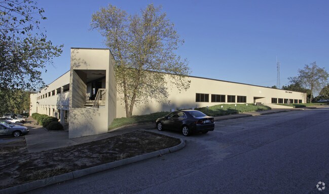


Property Detail
10 Skyview Dr
Greenville-Anderson-Greer, SC
MAP 0269.00
0269.00-01-031.01
GREENVILLE
Warehouse
South Carolina
C3
031.01
B and X Area of moderate flood hazard, usually the area between the limits of the 100-year and 500-year floods.
4.25 AC
2025
South Pleasantburg
2025
Greenville/Spartanburg
001400
NEARBY LISTINGS FOR SALE OR LEASE
DEMOGRAPHICS near 10 Skyview Dr
1 mile
3 mile
5 mile
2025 Total Population
7,476
70,976
176,261
2030 Population
7,960
77,192
191,107
Pop Growth 2025-2030
+ 6.47%
+ 8.76%
+ 8.42%
Average Age
39
39
39
2025 Total Households
3,419
32,764
76,506
HH Growth 2025-2030
+ 6.61%
+ 9.25%
+ 8.76%
Median Household Inc
$73,762
$72,608
$66,497
Avg Household Size
2.20
2.10
2.20
2025 Avg HH Vehicles
2.00
2.00
2.00
Median Home Value
$636,387
$524,078
$357,899
Median Year Built
1968
1983
1982
Nearby Places
Map Layers
Map Styles
 Street
 Aerial
Transit
 Traffic
 Biking
Places
Listings with unknown addresses are not visible on the map
- Restaurants
- Banks
- Shops
- Fitness
- Groceries
PUBLIC TRANSPORTATION
COMMUTER RAIL
Greenville Amtrak Station (Crescent - Amtrak)
Drive
Walk
Distance
Greenville Amtrak Station (Crescent - Amtrak)
11 min
4.3 mi
AIRPORT
Greenville Spartanburg International
Drive
Walk
Distance
Greenville Spartanburg International
22 min
12.9 mi
Freight Ports
North Charleston Terminal
Drive
Walk
Distance
North Charleston Terminal
229 min
200.5 mi
Nearby Properties
Address
Land Use
TOTAL SIZE
Lot Size
Zoning
Address
Land Use
TOTAL SIZE
Lot Size
Zoning
114.75 AC
0D
Address
Land Use
TOTAL SIZE
Lot Size
Zoning
330.98 AC
S1
Address
Land Use
TOTAL SIZE
Lot Size
Zoning
6.30 AC
C3
Address
Land Use
TOTAL SIZE
Lot Size
Zoning
2,945 SF
1.83 AC
S1
Address
Land Use
TOTAL SIZE
Lot Size
Zoning
47.63 AC
R6
Address
Land Use
TOTAL SIZE
Lot Size
Zoning
14.85 AC
S1
Address
Land Use
TOTAL SIZE
Lot Size
Zoning
29.53 AC
RM1
Address
Land Use
TOTAL SIZE
Lot Size
Zoning
123.10 AC
0D
Address
Land Use
TOTAL SIZE
Lot Size
Zoning
17.07 AC
S1
Address
Land Use
TOTAL SIZE
Lot Size
Zoning
0.45 AC
OD
Address
Land Use
TOTAL SIZE
Lot Size
Zoning
333.78 AC
S-1,I-1
Address
Land Use
TOTAL SIZE
Lot Size
Zoning
20.21 AC
Address
Land Use
TOTAL SIZE
Lot Size
Zoning
14.41 AC
RM2
Address
Land Use
TOTAL SIZE
Lot Size
Zoning
11.13 AC
OD
Address
Land Use
TOTAL SIZE
Lot Size
Zoning
1.89 AC
OD
Address
Land Use
TOTAL SIZE
Lot Size
Zoning
14.21 AC
RM2
Address
Land Use
TOTAL SIZE
Lot Size
Zoning
18.65 AC
R6
Address
Land Use
TOTAL SIZE
Lot Size
Zoning
9.91 AC
C3
Address
Land Use
TOTAL SIZE
Lot Size
Zoning
12.01 AC
RM2
Address
Land Use
TOTAL SIZE
Lot Size
Zoning
20.63 AC
S1
Address
Land Use
TOTAL SIZE
Lot Size
Zoning
15.32 AC
RM2
Address
Land Use
TOTAL SIZE
Lot Size
Zoning
1 AC
C4
Address
Land Use
TOTAL SIZE
Lot Size
Zoning
15 AC
OD
Address
Land Use
TOTAL SIZE
Lot Size
Zoning
0.47 AC
OD
Address
Land Use
TOTAL SIZE
Lot Size
Zoning
9.57 AC
C3
Address
Land Use
TOTAL SIZE
Lot Size
Zoning
15.82 AC
RM
Address
Land Use
TOTAL SIZE
Lot Size
Zoning
6.86 AC
S1
Address
Land Use
TOTAL SIZE
Lot Size
Zoning
54.35 AC
I-1
Address
Land Use
TOTAL SIZE
Lot Size
Zoning
10.07 AC
S1
Address
Land Use
TOTAL SIZE
Lot Size
Zoning
6.21 AC
C3
The World's #1 Commercial Real Estate Marketplace
Connect with us
© 2026 CoStar Group
The information above has been obtained from sources believed reliable. While we do not doubt its accuracy we have not verified it and make no guarantee, warranty or representation about it. It is your responsibility to independently confirm its accuracy and completeness. Any projections, opinions, assumptions, or estimates used are for example only and do not represent the current or future performance of the property. The value of this transaction to you depends on tax and other factors which should be evaluated by your tax, financial, and legal advisors. You and your advisors should conduct a careful, independent investigation of the property to determine to your satisfaction the suitability of the property for your needs.