Property Record
10 Unknown, Anytowne, OR 00000

Property Detail
10 Unknown
Eugene-Springfield, OR
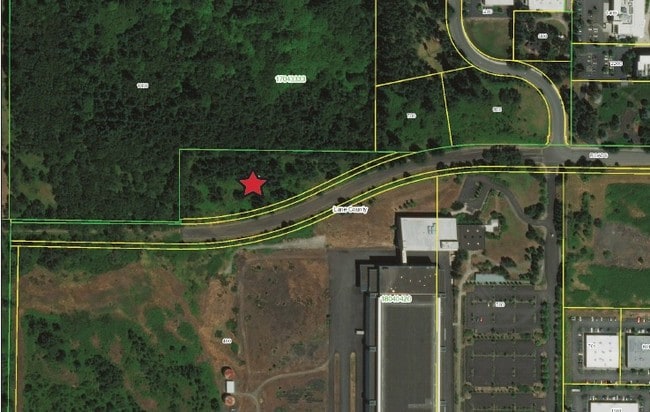
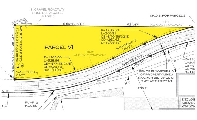
PARTITION PLAT 2009-P2415 PCL 2 TL 01000
1838679
LANE
Residentialacreage
Oregon
F2
1000
B and X Area of moderate flood hazard, usually the area between the limits of the 100-year and 500-year floods.
26.59 AC
2025
Lane County
2025
Portland
0010022005
NEARBY LISTINGS FOR SALE OR LEASE
DEMOGRAPHICS near 10 Unknown
1 mile
3 mile
5 mile
2024 Total Population
623
40,543
108,301
2029 Population
637
40,108
107,156
Pop Growth 2024-2029
+ 2.25%
(1.07%)
(1.06%)
Average Age
44
42
41
2024 Total Households
289
15,016
44,930
HH Growth 2024-2029
+ 2.08%
(1.21%)
(1.16%)
Median Household Inc
$36,666
$69,454
$64,781
Avg Household Size
2.10
2.40
2.20
2024 Avg HH Vehicles
2.00
2.00
2.00
Median Home Value
$942,622
$381,959
$426,317
Median Year Built
1991
1981
1975
Nearby Places
Map Layers
Map Styles
 Street
 Aerial
Transit
 Traffic
 Biking
Places
Listings with unknown addresses are not visible on the map
- Restaurants
- Banks
- Shops
- Fitness
- Groceries
PUBLIC TRANSPORTATION
COMMUTER RAIL
Eugene (Amtrak Cascades - Amtrak, Coast Starlight - Amtrak)
Drive
Walk
Distance
Eugene (Amtrak Cascades - Amtrak, Coast Starlight - Amtrak)
13 min
5.6 mi
AIRPORT
Mahlon Sweet Field
Drive
Walk
Distance
Mahlon Sweet Field
15 min
6.3 mi
Freight Ports
Port of Coos Bay, OR
Drive
Walk
Distance
Port of Coos Bay, OR
144 min
103.2 mi
SALE & LEASE HISTORY
LISTING DATE
SALE/LEASE

Sep 09, 2019
For Sale
Jan 17, 2022
For Sale
Nearby Properties
Address
Land Use
TOTAL SIZE
Lot Size
Zoning
Address
Land Use
TOTAL SIZE
Lot Size
Zoning
44.56 AC
PL
Address
Land Use
TOTAL SIZE
Lot Size
Zoning
Address
Land Use
TOTAL SIZE
Lot Size
Zoning
12.12 AC
C-2
Address
Land Use
TOTAL SIZE
Lot Size
Zoning
45.78 AC
I-3
Address
Land Use
TOTAL SIZE
Lot Size
Zoning
75.36 AC
PL
Address
Land Use
TOTAL SIZE
Lot Size
Zoning
14.14 AC
R-1
Address
Land Use
TOTAL SIZE
Lot Size
Zoning
19.65 AC
C-2
Address
Land Use
TOTAL SIZE
Lot Size
Zoning
3,324 SF
8.70 AC
NR
Address
Land Use
TOTAL SIZE
Lot Size
Zoning
27.47 AC
R-1
Address
Land Use
TOTAL SIZE
Lot Size
Zoning
12.07 AC
NR
Address
Land Use
TOTAL SIZE
Lot Size
Zoning
29.96 AC
AG
Address
Land Use
TOTAL SIZE
Lot Size
Zoning
Address
Land Use
TOTAL SIZE
Lot Size
Zoning
33.70 AC
R-1
Address
Land Use
TOTAL SIZE
Lot Size
Zoning
37.58 AC
PL
Address
Land Use
TOTAL SIZE
Lot Size
Zoning
13.14 AC
I-2
Address
Land Use
TOTAL SIZE
Lot Size
Zoning
4.97 AC
I-3
Address
Land Use
TOTAL SIZE
Lot Size
Zoning
10.50 AC
C-2
Address
Land Use
TOTAL SIZE
Lot Size
Zoning
5.13 AC
I-3
Address
Land Use
TOTAL SIZE
Lot Size
Zoning
3.12 AC
I-2
Address
Land Use
TOTAL SIZE
Lot Size
Zoning
12.30 AC
C-2
Address
Land Use
TOTAL SIZE
Lot Size
Zoning
Address
Land Use
TOTAL SIZE
Lot Size
Zoning
16.18 AC
E-1
Address
Land Use
TOTAL SIZE
Lot Size
Zoning
11.13 AC
C-2
Address
Land Use
TOTAL SIZE
Lot Size
Zoning
25.02 AC
PL
Address
Land Use
TOTAL SIZE
Lot Size
Zoning
560 SF
11.02 AC
I-2
Address
Land Use
TOTAL SIZE
Lot Size
Zoning
2.32 AC
E-2
Address
Land Use
TOTAL SIZE
Lot Size
Zoning
13.55 AC
R-1
Address
Land Use
TOTAL SIZE
Lot Size
Zoning
9.46 AC
C-2
Address
Land Use
TOTAL SIZE
Lot Size
Zoning
3,980 SF
85.16 AC
AG
Address
Land Use
TOTAL SIZE
Lot Size
Zoning
2.93 AC
I-3
The World's #1 Commercial Real Estate Marketplace
Connect with us
© 2026 CoStar Group
The information above has been obtained from sources believed reliable. While we do not doubt its accuracy we have not verified it and make no guarantee, warranty or representation about it. It is your responsibility to independently confirm its accuracy and completeness. Any projections, opinions, assumptions, or estimates used are for example only and do not represent the current or future performance of the property. The value of this transaction to you depends on tax and other factors which should be evaluated by your tax, financial, and legal advisors. You and your advisors should conduct a careful, independent investigation of the property to determine to your satisfaction the suitability of the property for your needs.