Property Record
10 Unknown Ln, Anytowne, OR 00000


NEARBY LISTINGS FOR SALE OR LEASE
Property Detail
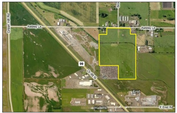
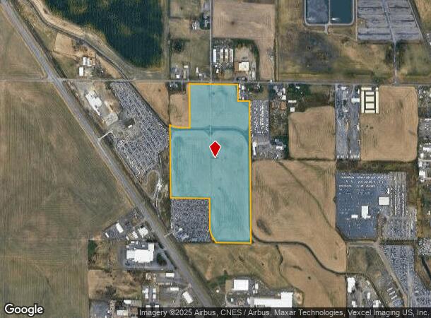
10 Unknown Ln
Eugene-Springfield, OR
2008-P2298
1824521
PARTITION PLAT 2008-P2298 PCL 1 TL 00803
Industrialgeneral
Lane
A
Oregon
41039C1106F
803
2025
57.23 AC
2025
Lane County
0024011008
Portland
DEMOGRAPHICS near 10 Unknown Ln
1 Mile
3 Mile
5 Mile
2024 Total Population
134
28,381
75,664
2029 Population
133
28,213
75,461
Pop Growth 2024-2029
(0.75%)
(0.59%)
(0.27%)
Average Age
44
42
42
2024 Total Households
51
11,010
29,135
HH Growth 2024-2029
(1.96%)
(0.64%)
(0.33%)
Median Household Inc
$92,856
$76,603
$69,252
Avg Household Size
2.60
2.50
2.40
2024 Avg HH Vehicles
3.00
2.00
2.00
Median Home Value
$379,411
$347,146
$333,290
Median Year Built
1990
1979
1979
Nearby Places
Map Layers
Map Styles
 Street
 Aerial
- Restaurants
- Banks
- Shops
- Fitness
- Groceries
PUBLIC TRANSPORTATION
COMMUTER RAIL
Eugene (Amtrak Cascades - Amtrak, Coast Starlight - Amtrak)
DRIVE
WALK
Distance
Eugene (Amtrak Cascades - Amtrak, Coast Starlight - Amtrak)
14 min
8.6 mi
AIRPORT
Mahlon Sweet Field
DRIVE
WALK
Distance
Mahlon Sweet Field
9 min
3.9 mi
Freight Ports
Port of Coos Bay, OR
DRIVE
WALK
Distance
Port of Coos Bay, OR
153 min
110.3 mi
SALE & LEASE HISTORY
LISTING DATE
SALE/LEASE

Sep 24, 2016
For Sale
Nearby Properties
Address
Land Use
TOTAL SIZE
Lot Size
Zoning
Address
Land Use
TOTAL SIZE
Lot Size
Zoning
Address
Land Use
TOTAL SIZE
Lot Size
Zoning
52.04 AC
M3
Address
Land Use
TOTAL SIZE
Lot Size
Zoning
664.30 AC
AO
Address
Land Use
TOTAL SIZE
Lot Size
Zoning
27.33 AC
M1
Address
Land Use
TOTAL SIZE
Lot Size
Zoning
121.21 AC
E40
Address
Land Use
TOTAL SIZE
Lot Size
Zoning
Address
Land Use
TOTAL SIZE
Lot Size
Zoning
Address
Land Use
TOTAL SIZE
Lot Size
Zoning
27.47 AC
R-1
Address
Land Use
TOTAL SIZE
Lot Size
Zoning
44.67 AC
I-2
Address
Land Use
TOTAL SIZE
Lot Size
Zoning
14.20 AC
R-1
Address
Land Use
TOTAL SIZE
Lot Size
Zoning
37.58 AC
PL
Address
Land Use
TOTAL SIZE
Lot Size
Zoning
Address
Land Use
TOTAL SIZE
Lot Size
Zoning
Address
Land Use
TOTAL SIZE
Lot Size
Zoning
8.13 AC
R-1
Address
Land Use
TOTAL SIZE
Lot Size
Zoning
31.30 AC
I-3
Address
Land Use
TOTAL SIZE
Lot Size
Zoning
4.62 AC
AG
Address
Land Use
TOTAL SIZE
Lot Size
Zoning
Address
Land Use
TOTAL SIZE
Lot Size
Zoning
Address
Land Use
TOTAL SIZE
Lot Size
Zoning
5.38 AC
I-2
Address
Land Use
TOTAL SIZE
Lot Size
Zoning
8.03 AC
C-2
Address
Land Use
TOTAL SIZE
Lot Size
Zoning
Address
Land Use
TOTAL SIZE
Lot Size
Zoning
Address
Land Use
TOTAL SIZE
Lot Size
Zoning
25.80 AC
I-3
Address
Land Use
TOTAL SIZE
Lot Size
Zoning
Address
Land Use
TOTAL SIZE
Lot Size
Zoning
2.44 AC
R-2
Address
Land Use
TOTAL SIZE
Lot Size
Zoning
3.60 AC
I-2
Address
Land Use
TOTAL SIZE
Lot Size
Zoning
10.92 AC
I-2
Address
Land Use
TOTAL SIZE
Lot Size
Zoning
Address
Land Use
TOTAL SIZE
Lot Size
Zoning
6.74 AC
I-2
Address
Land Use
TOTAL SIZE
Lot Size
Zoning
1,728 SF
10.69 AC
AG
The World's #1 Commercial Real Estate Marketplace
Connect with us
© 2026 CoStar Group
The information above has been obtained from sources believed reliable. While we do not doubt its accuracy we have not verified it and make no guarantee, warranty or representation about it. It is your responsibility to independently confirm its accuracy and completeness. Any projections, opinions, assumptions, or estimates used are for example only and do not represent the current or future performance of the property. The value of this transaction to you depends on tax and other factors which should be evaluated by your tax, financial, and legal advisors. You and your advisors should conduct a careful, independent investigation of the property to determine to your satisfaction the suitability of the property for your needs.