Property Record
10 W Hoffman Blvd, Hoffman Estates, IL 60192
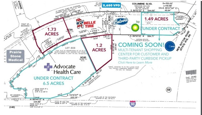


This Property Is For Sale
NEARBY LISTINGS FOR SALE OR LEASE
-
-
-
-
-
East Side of Barrington Rd, North Of Lakewood Blvd
Hoffman Estates, IL 60010
Rent Upon Request
1.17 AC Lots
Land
-
View all Hoffman Estates listings for sale on LoopNet.com
Property Detail
10 W Hoffman Blvd
01-33-304-005-0000
Cook
Vacantlandnec
Illinois
X
3.42 AC
17089C0180H
Schaumburg Area
2022
Chicago
2025
Chicago-Naperville-Elgin, IL-IN
804203
DEMOGRAPHICS near 10 W Hoffman Blvd
1 mile
3 mile
5 mile
2024 Total Population
1,245
25,062
170,816
2029 Population
1,194
24,201
166,433
Pop Growth 2024-2029
(4.10%)
(3.44%)
(2.57%)
Average Age
42
42
39
2024 Total Households
378
8,645
57,705
HH Growth 2024-2029
(4.50%)
(3.70%)
(2.85%)
Median Household Inc
$136,184
$105,007
$86,572
Avg Household Size
3.30
2.80
2.90
2024 Avg HH Vehicles
2.00
2.00
2.00
Median Home Value
$475,827
$331,446
$256,427
Median Year Built
1996
1991
1978
Nearby Places
Map Layers
Map Styles
 Street
 Aerial
Transit
 Traffic
 Biking
Places
Listings with unknown addresses are not visible on the map
- Restaurants
- Banks
- Shops
- Fitness
- Groceries
PUBLIC TRANSPORTATION
COMMUTER RAIL
Elgin Station (Milwaukee District West Line - Northeast Illinois Regional Commuter Railroad (Metra))
Drive
Walk
Distance
Elgin Station (Milwaukee District West Line - Northeast Illinois Regional Commuter Railroad (Metra))
12 min
6.9 mi
National Street Station (Milwaukee District West Line - Northeast Illinois Regional Commuter Railroad (Metra))
Drive
Walk
Distance
National Street Station (Milwaukee District West Line - Northeast Illinois Regional Commuter Railroad (Metra))
14 min
7.6 mi
AIRPORT
Chicago O'Hare International
Drive
Walk
Distance
Chicago O'Hare International
27 min
21.6 mi
Freight Ports
Port Milwaukee
Drive
Walk
Distance
Port Milwaukee
103 min
76.9 mi
Nearby Properties
Address
Land Use
TOTAL SIZE
Lot Size
Zoning
Address
Land Use
TOTAL SIZE
Lot Size
Zoning
51,091 SF
3.52 AC
Address
Land Use
TOTAL SIZE
Lot Size
Zoning
258,989 SF
27.84 AC
Address
Land Use
TOTAL SIZE
Lot Size
Zoning
Address
Land Use
TOTAL SIZE
Lot Size
Zoning
382,200 SF
45.71 AC
Address
Land Use
TOTAL SIZE
Lot Size
Zoning
527,661 SF
27.39 AC
Address
Land Use
TOTAL SIZE
Lot Size
Zoning
110,940 SF
25.28 AC
Address
Land Use
TOTAL SIZE
Lot Size
Zoning
71,725 SF
49.30 AC
Address
Land Use
TOTAL SIZE
Lot Size
Zoning
Address
Land Use
TOTAL SIZE
Lot Size
Zoning
201,539 SF
15.66 AC
Address
Land Use
TOTAL SIZE
Lot Size
Zoning
240,352 SF
9.65 AC
Address
Land Use
TOTAL SIZE
Lot Size
Zoning
Address
Land Use
TOTAL SIZE
Lot Size
Zoning
227,125 SF
2.79 AC
Address
Land Use
TOTAL SIZE
Lot Size
Zoning
7,200 SF
16.86 AC
Address
Land Use
TOTAL SIZE
Lot Size
Zoning
2,415,708 SF
124.06 AC
Address
Land Use
TOTAL SIZE
Lot Size
Zoning
123,875 SF
10.91 AC
Address
Land Use
TOTAL SIZE
Lot Size
Zoning
272,944 SF
4.74 AC
Address
Land Use
TOTAL SIZE
Lot Size
Zoning
109,316 SF
4.73 AC
Address
Land Use
TOTAL SIZE
Lot Size
Zoning
161,280 SF
5.50 AC
Address
Land Use
TOTAL SIZE
Lot Size
Zoning
44.10 AC
Address
Land Use
TOTAL SIZE
Lot Size
Zoning
90,640 SF
18.99 AC
Address
Land Use
TOTAL SIZE
Lot Size
Zoning
1,352 SF
1.27 AC
Address
Land Use
TOTAL SIZE
Lot Size
Zoning
69,221 SF
3.22 AC
Address
Land Use
TOTAL SIZE
Lot Size
Zoning
49,476 SF
4.70 AC
Address
Land Use
TOTAL SIZE
Lot Size
Zoning
108,115 SF
3.74 AC
Address
Land Use
TOTAL SIZE
Lot Size
Zoning
11,200 SF
50.39 AC
Address
Land Use
TOTAL SIZE
Lot Size
Zoning
75,970 SF
5 AC
Address
Land Use
TOTAL SIZE
Lot Size
Zoning
190,099 SF
24.23 AC
Address
Land Use
TOTAL SIZE
Lot Size
Zoning
62,840 SF
9.25 AC
Address
Land Use
TOTAL SIZE
Lot Size
Zoning
The World's #1 Commercial Real Estate Marketplace
Connect with us
© 2026 CoStar Group
The information above has been obtained from sources believed reliable. While we do not doubt its accuracy we have not verified it and make no guarantee, warranty or representation about it. It is your responsibility to independently confirm its accuracy and completeness. Any projections, opinions, assumptions, or estimates used are for example only and do not represent the current or future performance of the property. The value of this transaction to you depends on tax and other factors which should be evaluated by your tax, financial, and legal advisors. You and your advisors should conduct a careful, independent investigation of the property to determine to your satisfaction the suitability of the property for your needs.