Property Record
10 W Main St, Woodland, CA 95695

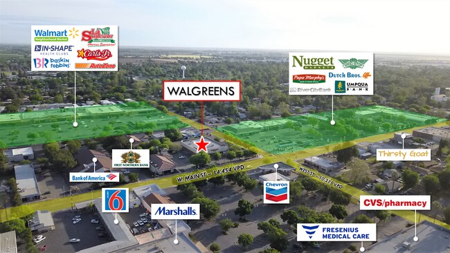

NEARBY LISTINGS FOR SALE OR LEASE
Property Detail
10 W Main St
064-130-037-000
Parcel Map No 2174
Storemultistory
COC 1997-10842 PCL 2
X
Yolo
06113C0445H
California
2024
0.83 AC
2025
Woodland
010902
Sacramento
13,783 SF
Sacramento--Roseville--Arden-Arcade, CA
DEMOGRAPHICS near 10 W Main St
1 Mile
3 Mile
5 Mile
2024 Total Population
23,048
56,183
65,916
2029 Population
23,324
56,913
66,906
Pop Growth 2024-2029
+ 1.20%
+ 1.30%
+ 1.50%
Average Age
39
38
38
2024 Total Households
8,395
19,342
22,447
HH Growth 2024-2029
+ 1.18%
+ 1.30%
+ 1.48%
Median Household Inc
$63,316
$73,894
$79,232
Avg Household Size
2.60
2.80
2.80
2024 Avg HH Vehicles
2.00
2.00
2.00
Median Home Value
$440,878
$453,490
$472,801
Median Year Built
1971
1978
1981
Nearby Places
Map Layers
Map Styles
 Street
 Aerial
- Restaurants
- Banks
- Shops
- Fitness
- Groceries
PUBLIC TRANSPORTATION
AIRPORT
Sacramento International
DRIVE
WALK
Distance
Sacramento International
21 min
12.4 mi
SALE & LEASE HISTORY
LISTING DATE
SALE/LEASE

May 12, 2020
For Sale
Nearby Properties
Address
Land Use
TOTAL SIZE
Lot Size
Zoning
Address
Land Use
TOTAL SIZE
Lot Size
Zoning
23.92 AC
M2
Address
Land Use
TOTAL SIZE
Lot Size
Zoning
112.50 AC
A1
Address
Land Use
TOTAL SIZE
Lot Size
Zoning
180,816 SF
0.17 AC
R-M
Address
Land Use
TOTAL SIZE
Lot Size
Zoning
12,032 SF
0.12 AC
R3
Address
Land Use
TOTAL SIZE
Lot Size
Zoning
515,886 SF
71.53 AC
I
Address
Land Use
TOTAL SIZE
Lot Size
Zoning
348,386 SF
17.67 AC
RM
Address
Land Use
TOTAL SIZE
Lot Size
Zoning
150,269 SF
6.95 AC
R-M
Address
Land Use
TOTAL SIZE
Lot Size
Zoning
9.89 AC
M1
Address
Land Use
TOTAL SIZE
Lot Size
Zoning
87.49 AC
A1
Address
Land Use
TOTAL SIZE
Lot Size
Zoning
38.27 AC
I
Address
Land Use
TOTAL SIZE
Lot Size
Zoning
67,104 SF
0.32 AC
R25
Address
Land Use
TOTAL SIZE
Lot Size
Zoning
260,400 SF
12.30 AC
I
Address
Land Use
TOTAL SIZE
Lot Size
Zoning
83,280 SF
0.22 AC
R-M
Address
Land Use
TOTAL SIZE
Lot Size
Zoning
260,400 SF
12.79 AC
I
Address
Land Use
TOTAL SIZE
Lot Size
Zoning
4,000 SF
51.48 AC
A1
Address
Land Use
TOTAL SIZE
Lot Size
Zoning
4.46 AC
C-3
Address
Land Use
TOTAL SIZE
Lot Size
Zoning
356,360 SF
26.50 AC
M2
Address
Land Use
TOTAL SIZE
Lot Size
Zoning
324,475 SF
22.49 AC
I
Address
Land Use
TOTAL SIZE
Lot Size
Zoning
427,073 SF
24.51 AC
I
Address
Land Use
TOTAL SIZE
Lot Size
Zoning
145,694 SF
9.26 AC
MDR20
Address
Land Use
TOTAL SIZE
Lot Size
Zoning
26.48 AC
A1
Address
Land Use
TOTAL SIZE
Lot Size
Zoning
71,493 SF
1.98 AC
C3
Address
Land Use
TOTAL SIZE
Lot Size
Zoning
2.98 AC
C2
Address
Land Use
TOTAL SIZE
Lot Size
Zoning
94,860 SF
11.70 AC
EOZ-I/PD
Address
Land Use
TOTAL SIZE
Lot Size
Zoning
128,755 SF
13.61 AC
C2
Address
Land Use
TOTAL SIZE
Lot Size
Zoning
0.21 AC
R1
Address
Land Use
TOTAL SIZE
Lot Size
Zoning
13,833 SF
5.69 AC
I
Address
Land Use
TOTAL SIZE
Lot Size
Zoning
101,334 SF
8.52 AC
C2
Address
Land Use
TOTAL SIZE
Lot Size
Zoning
9.83 AC
R-M
Address
Land Use
TOTAL SIZE
Lot Size
Zoning
90,570 SF
8.08 AC
C2
The World's #1 Commercial Real Estate Marketplace
Connect with us
© 2026 CoStar Group
The information above has been obtained from sources believed reliable. While we do not doubt its accuracy we have not verified it and make no guarantee, warranty or representation about it. It is your responsibility to independently confirm its accuracy and completeness. Any projections, opinions, assumptions, or estimates used are for example only and do not represent the current or future performance of the property. The value of this transaction to you depends on tax and other factors which should be evaluated by your tax, financial, and legal advisors. You and your advisors should conduct a careful, independent investigation of the property to determine to your satisfaction the suitability of the property for your needs.