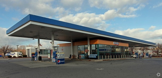
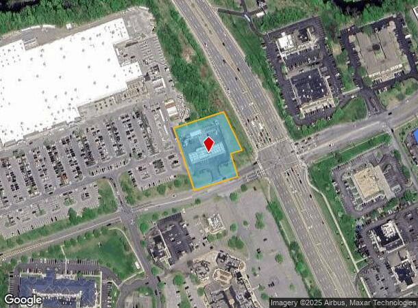
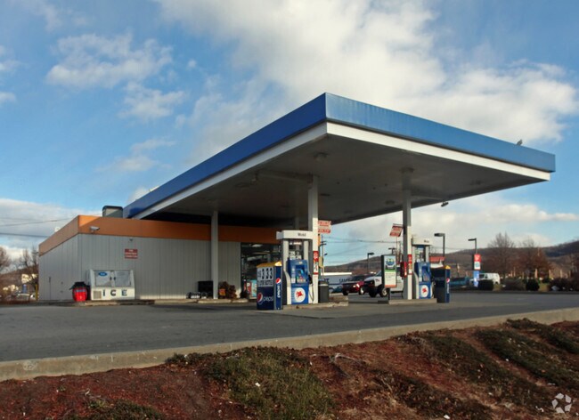
Property Record
10 W Merritt Blvd, Fishkill, NY 12524
NEARBY LISTINGS FOR SALE OR LEASE
Property Detail
10 W Merritt Blvd
Kiryas Joel-Poughkeepsie-Newburgh, NY
Wdg Dutchess Assoc
133089-6155-00-999769-0000
1.25 AC(S) 1854 0672
Servicestation
Dutchess
AE
New York
36027C0469E
999
2025
1.25 AC
2024
Fishkill
060201
Westchester/So Connecticut
2,709 SF
DEMOGRAPHICS near 10 W Merritt Blvd
1 Mile
3 Mile
5 Mile
2024 Total Population
4,660
21,911
66,700
2029 Population
4,681
21,864
66,602
Pop Growth 2024-2029
+ 0.45%
(0.21%)
(0.15%)
Average Age
45
45
43
2024 Total Households
2,156
8,909
26,661
HH Growth 2024-2029
+ 0.42%
(0.21%)
(0.18%)
Median Household Inc
$86,450
$87,078
$92,852
Avg Household Size
2.10
2.30
2.40
2024 Avg HH Vehicles
2.00
2.00
2.00
Median Home Value
$367,948
$370,775
$377,031
Median Year Built
1982
1976
1972
Nearby Places
Map Layers
Map Styles
 Street
 Aerial
- Restaurants
- Banks
- Shops
- Fitness
- Groceries
PUBLIC TRANSPORTATION
COMMUTER RAIL
New Hamburg Station (Hudson Line - Metro-North Commuter Railroad Company (Metro-North))
DRIVE
WALK
Distance
New Hamburg Station (Hudson Line - Metro-North Commuter Railroad Company (Metro-North))
10 min
6.0 mi
Beacon Station (Hudson Line - Metro-North Commuter Railroad Company (Metro-North))
DRIVE
WALK
Distance
Beacon Station (Hudson Line - Metro-North Commuter Railroad Company (Metro-North))
10 min
6.3 mi
AIRPORT
New York Stewart International
DRIVE
WALK
Distance
New York Stewart International
24 min
14.8 mi
Freight Ports
Port of New Haven
DRIVE
WALK
Distance
Port of New Haven
92 min
67.7 mi
Nearby Properties
Address
Land Use
TOTAL SIZE
Lot Size
Zoning
Address
Land Use
TOTAL SIZE
Lot Size
Zoning
1,240,333 SF
120.58 AC
PI
Address
Land Use
TOTAL SIZE
Lot Size
Zoning
137,278 SF
41.20 AC
R-50
Address
Land Use
TOTAL SIZE
Lot Size
Zoning
773,000 SF
6.80 AC
PI
Address
Land Use
TOTAL SIZE
Lot Size
Zoning
56,704 SF
5.03 AC
PSC
Address
Land Use
TOTAL SIZE
Lot Size
Zoning
123,536 SF
18.10 AC
GB
Address
Land Use
TOTAL SIZE
Lot Size
Zoning
118,800 SF
8.46 AC
PI
Address
Land Use
TOTAL SIZE
Lot Size
Zoning
28,362 SF
1,116.34 AC
R4A
Address
Land Use
TOTAL SIZE
Lot Size
Zoning
248,686 SF
0.01 AC
PSC
Address
Land Use
TOTAL SIZE
Lot Size
Zoning
206,064 SF
31.72 AC
PI
Address
Land Use
TOTAL SIZE
Lot Size
Zoning
6.30 AC
PSC
Address
Land Use
TOTAL SIZE
Lot Size
Zoning
99,569 SF
16.10 AC
PSC
Address
Land Use
TOTAL SIZE
Lot Size
Zoning
105,500 SF
8.50 AC
RB
Address
Land Use
TOTAL SIZE
Lot Size
Zoning
72,222 SF
7.62 AC
PSC
Address
Land Use
TOTAL SIZE
Lot Size
Zoning
27,472 SF
0.67 AC
LI
Address
Land Use
TOTAL SIZE
Lot Size
Zoning
32,347 SF
17.10 AC
R20
Address
Land Use
TOTAL SIZE
Lot Size
Zoning
133,362 SF
18.85 AC
PSC
Address
Land Use
TOTAL SIZE
Lot Size
Zoning
38,699 SF
3.09 AC
GB
Address
Land Use
TOTAL SIZE
Lot Size
Zoning
117,740 SF
6.34 AC
PSC
Address
Land Use
TOTAL SIZE
Lot Size
Zoning
8,960 SF
6.28 AC
PSC
Address
Land Use
TOTAL SIZE
Lot Size
Zoning
49.90 AC
GB
Address
Land Use
TOTAL SIZE
Lot Size
Zoning
45,720 SF
13.68 AC
RMF5
Address
Land Use
TOTAL SIZE
Lot Size
Zoning
52,988 SF
3.80 AC
LHCSB
Address
Land Use
TOTAL SIZE
Lot Size
Zoning
47,968 SF
5.19 AC
GB
Address
Land Use
TOTAL SIZE
Lot Size
Zoning
54,595 SF
11 AC
R15
Address
Land Use
TOTAL SIZE
Lot Size
Zoning
132,874 SF
13.49 AC
GB
Address
Land Use
TOTAL SIZE
Lot Size
Zoning
56,824 SF
10 AC
RMF5
Address
Land Use
TOTAL SIZE
Lot Size
Zoning
26,128 SF
3.43 AC
PI
Address
Land Use
TOTAL SIZE
Lot Size
Zoning
109,900 SF
11.17 AC
PB
Address
Land Use
TOTAL SIZE
Lot Size
Zoning
98,993 SF
3.52 AC
PSC
Address
Land Use
TOTAL SIZE
Lot Size
Zoning
47,474 SF
8.07 AC
HI
The World's #1 Commercial Real Estate Marketplace
Connect with us
© 2026 CoStar Group
The information above has been obtained from sources believed reliable. While we do not doubt its accuracy we have not verified it and make no guarantee, warranty or representation about it. It is your responsibility to independently confirm its accuracy and completeness. Any projections, opinions, assumptions, or estimates used are for example only and do not represent the current or future performance of the property. The value of this transaction to you depends on tax and other factors which should be evaluated by your tax, financial, and legal advisors. You and your advisors should conduct a careful, independent investigation of the property to determine to your satisfaction the suitability of the property for your needs.