Property Record
10 Fruit Ave, Farrell, PA 16121


Save to a Folder
{{folder.Name}}
{{folder.ListingIds.length}} Properties
{{folder.ListingIds.length}} Property
Create a New Folder
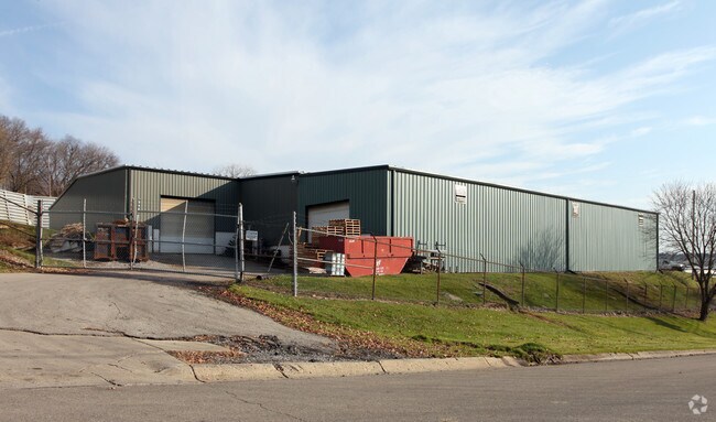
Property Detail
10 Fruit Ave
Hermitage, PA
WALLIS AVE BLDG
52-431-339
MERCER
Industrialgeneral
Pennsylvania
B and X Area of moderate flood hazard, usually the area between the limits of the 100-year and 500-year floods.
2.70 AC
2026
Mercer County
2026
Youngstown/Warren/Boardman
033400
NEARBY LISTINGS FOR SALE OR LEASE
DEMOGRAPHICS near 10 Fruit Ave
1 mile
3 mile
5 mile
2025 Total Population
3,823
29,326
54,029
2030 Population
3,785
29,218
53,407
Pop Growth 2025-2030
(0.99%)
(0.37%)
(1.15%)
Average Age
43
43
44
2025 Total Households
1,766
12,973
23,892
HH Growth 2025-2030
(1.36%)
(0.60%)
(1.32%)
Median Household Inc
$36,753
$49,211
$56,693
Avg Household Size
2.10
2.20
2.20
2025 Avg HH Vehicles
1.00
1.00
2.00
Median Home Value
$72,784
$99,664
$140,241
Median Year Built
1955
1954
1958
Nearby Places
Map Layers
Map Styles
 Street
 Aerial
Layers
 Traffic
 Biking
Places
Listings with unknown addresses are not visible on the map
- Restaurants
- Banks
- Shops
- Fitness
- Groceries
Nearby Properties
Address
Land Use
TOTAL SIZE
Lot Size
Zoning
Address
Land Use
TOTAL SIZE
Lot Size
Zoning
13.39 AC
Address
Land Use
TOTAL SIZE
Lot Size
Zoning
Address
Land Use
TOTAL SIZE
Lot Size
Zoning
64.41 AC
Address
Land Use
TOTAL SIZE
Lot Size
Zoning
7.85 AC
Address
Land Use
TOTAL SIZE
Lot Size
Zoning
13.25 AC
Address
Land Use
TOTAL SIZE
Lot Size
Zoning
10.35 AC
Address
Land Use
TOTAL SIZE
Lot Size
Zoning
Address
Land Use
TOTAL SIZE
Lot Size
Zoning
Address
Land Use
TOTAL SIZE
Lot Size
Zoning
Address
Land Use
TOTAL SIZE
Lot Size
Zoning
0.30 AC
Address
Land Use
TOTAL SIZE
Lot Size
Zoning
Address
Land Use
TOTAL SIZE
Lot Size
Zoning
26.69 AC
Address
Land Use
TOTAL SIZE
Lot Size
Zoning
Address
Land Use
TOTAL SIZE
Lot Size
Zoning
Address
Land Use
TOTAL SIZE
Lot Size
Zoning
146,766 SF
1.24 AC
Address
Land Use
TOTAL SIZE
Lot Size
Zoning
0.10 AC
Address
Land Use
TOTAL SIZE
Lot Size
Zoning
Address
Land Use
TOTAL SIZE
Lot Size
Zoning
16.80 AC
Address
Land Use
TOTAL SIZE
Lot Size
Zoning
5.97 AC
Address
Land Use
TOTAL SIZE
Lot Size
Zoning
Address
Land Use
TOTAL SIZE
Lot Size
Zoning
41,342 SF
7.30 AC
Address
Land Use
TOTAL SIZE
Lot Size
Zoning
11,138 SF
34.26 AC
Address
Land Use
TOTAL SIZE
Lot Size
Zoning
147,800 SF
6.42 AC
Address
Land Use
TOTAL SIZE
Lot Size
Zoning
13.78 AC
Address
Land Use
TOTAL SIZE
Lot Size
Zoning
8.28 AC
Address
Land Use
TOTAL SIZE
Lot Size
Zoning
Address
Land Use
TOTAL SIZE
Lot Size
Zoning
0.90 AC
Address
Land Use
TOTAL SIZE
Lot Size
Zoning
1.80 AC
Address
Land Use
TOTAL SIZE
Lot Size
Zoning
Address
Land Use
TOTAL SIZE
Lot Size
Zoning
4.75 AC
The World's #1 Commercial Real Estate Marketplace
Connect with us
© 2026 CoStar Group
The information above has been obtained from sources believed reliable. While we do not doubt its accuracy we have not verified it and make no guarantee, warranty or representation about it. It is your responsibility to independently confirm its accuracy and completeness. Any projections, opinions, assumptions, or estimates used are for example only and do not represent the current or future performance of the property. The value of this transaction to you depends on tax and other factors which should be evaluated by your tax, financial, and legal advisors. You and your advisors should conduct a careful, independent investigation of the property to determine to your satisfaction the suitability of the property for your needs.