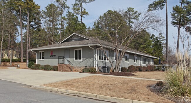
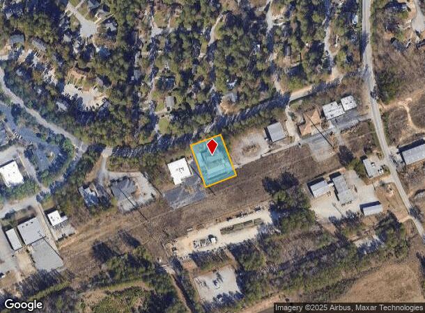
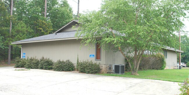
Property Record
10 Woodcross Dr, Columbia, SC 29212

NEARBY LISTINGS FOR SALE OR LEASE
Property Detail
10 Woodcross Dr
Columbia, SC
Irmo Whiterock Ballentine
04910-01-12
LOT 4 BLK 20 150.2X199.8X150.2X200 #SU HARBISON #PR RB1484-745 53-5578 Y-9502
Commercialnec
Richland
X
South Carolina
45063C0134J
4
2025
0.69 AC
2024
St Andrews
010304
Columbia
4,108 SF
DEMOGRAPHICS near 10 Woodcross Dr
1 Mile
3 Mile
5 Mile
2024 Total Population
6,380
50,023
99,581
2029 Population
6,567
52,266
104,044
Pop Growth 2024-2029
+ 2.93%
+ 4.48%
+ 4.48%
Average Age
39
40
39
2024 Total Households
3,074
20,278
41,154
HH Growth 2024-2029
+ 2.57%
+ 4.88%
+ 4.74%
Median Household Inc
$47,731
$53,963
$58,833
Avg Household Size
2.00
2.20
2.30
2024 Avg HH Vehicles
2.00
2.00
2.00
Median Home Value
$124,322
$168,605
$179,330
Median Year Built
1984
1980
1983
Nearby Places
Map Layers
Map Styles
 Street
 Aerial
- Restaurants
- Banks
- Shops
- Fitness
- Groceries
PUBLIC TRANSPORTATION
COMMUTER RAIL
DRIVE
WALK
Distance
16 min
9.3 mi
AIRPORT
Columbia Metro
DRIVE
WALK
Distance
Columbia Metro
27 min
14.1 mi
SALE & LEASE HISTORY
LISTING DATE
SALE/LEASE

Apr 10, 2020
For Sale
Nearby Properties
Address
Land Use
TOTAL SIZE
Lot Size
Zoning
Address
Land Use
TOTAL SIZE
Lot Size
Zoning
24.90 AC
PD
Address
Land Use
TOTAL SIZE
Lot Size
Zoning
128,877 SF
24.71 AC
RM-HD
Address
Land Use
TOTAL SIZE
Lot Size
Zoning
370,876 SF
14.43 AC
PD
Address
Land Use
TOTAL SIZE
Lot Size
Zoning
302,835 SF
11.48 AC
PD
Address
Land Use
TOTAL SIZE
Lot Size
Zoning
241,756 SF
14.25 AC
PD
Address
Land Use
TOTAL SIZE
Lot Size
Zoning
1,549.59 AC
T/C
Address
Land Use
TOTAL SIZE
Lot Size
Zoning
215,796 SF
12.71 AC
PD
Address
Land Use
TOTAL SIZE
Lot Size
Zoning
73,380 SF
16.07 AC
PDD
Address
Land Use
TOTAL SIZE
Lot Size
Zoning
2,268 SF
27.70 AC
RM-1
Address
Land Use
TOTAL SIZE
Lot Size
Zoning
195,550 SF
17.19 AC
GC
Address
Land Use
TOTAL SIZE
Lot Size
Zoning
100 SF
465.41 AC
INS-GEN
Address
Land Use
TOTAL SIZE
Lot Size
Zoning
192,966 SF
13.23 AC
RM-HD
Address
Land Use
TOTAL SIZE
Lot Size
Zoning
178,000 SF
11.71 AC
RM-1
Address
Land Use
TOTAL SIZE
Lot Size
Zoning
159,139 SF
16.95 AC
GC
Address
Land Use
TOTAL SIZE
Lot Size
Zoning
146,254 SF
12.12 AC
PD
Address
Land Use
TOTAL SIZE
Lot Size
Zoning
126,596 SF
10.84 AC
PD
Address
Land Use
TOTAL SIZE
Lot Size
Zoning
86,542 SF
3.25 AC
PD
Address
Land Use
TOTAL SIZE
Lot Size
Zoning
88,284 SF
0.78 AC
PD
Address
Land Use
TOTAL SIZE
Lot Size
Zoning
81,197 SF
10.34 AC
C-3
Address
Land Use
TOTAL SIZE
Lot Size
Zoning
153,210 SF
31.78 AC
LM
Address
Land Use
TOTAL SIZE
Lot Size
Zoning
87,200 SF
7 AC
PDD
Address
Land Use
TOTAL SIZE
Lot Size
Zoning
187,298 SF
9.11 AC
PD
Address
Land Use
TOTAL SIZE
Lot Size
Zoning
136,641 SF
9 AC
PDD
Address
Land Use
TOTAL SIZE
Lot Size
Zoning
307,287 SF
22.18 AC
RM-HD
Address
Land Use
TOTAL SIZE
Lot Size
Zoning
32.33 AC
PD
Address
Land Use
TOTAL SIZE
Lot Size
Zoning
44,296 SF
14.01 AC
GC
Address
Land Use
TOTAL SIZE
Lot Size
Zoning
82,874 SF
6.99 AC
GC
Address
Land Use
TOTAL SIZE
Lot Size
Zoning
141,468 SF
13.57 AC
RM-HD
Address
Land Use
TOTAL SIZE
Lot Size
Zoning
61,333 SF
3.23 AC
PD
Address
Land Use
TOTAL SIZE
Lot Size
Zoning
70,390 SF
12.76 AC
CAC
The World's #1 Commercial Real Estate Marketplace
Connect with us
© 2025 CoStar Group
The information above has been obtained from sources believed reliable. While we do not doubt its accuracy we have not verified it and make no guarantee, warranty or representation about it. It is your responsibility to independently confirm its accuracy and completeness. Any projections, opinions, assumptions, or estimates used are for example only and do not represent the current or future performance of the property. The value of this transaction to you depends on tax and other factors which should be evaluated by your tax, financial, and legal advisors. You and your advisors should conduct a careful, independent investigation of the property to determine to your satisfaction the suitability of the property for your needs.