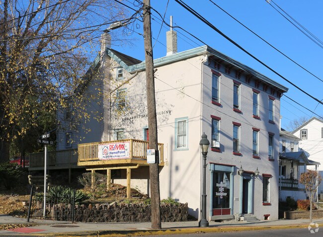
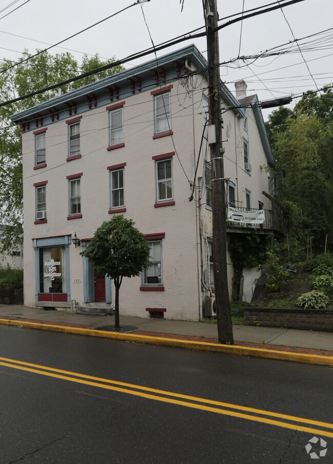
Property Record
102 S Main St, Spring City, PA 19475
NEARBY LISTINGS FOR SALE OR LEASE
Property Detail
102 S Main St
14-004-0511.0000
LOT & DWG
Duplex
Chester
X
Pennsylvania
42029C0060G
0.11 AC
2024
Exton/Whitelands
2025
Philadelphia
301100
Philadelphia-Camden-Wilmington, PA-NJ-DE-MD
1,608 SF
DEMOGRAPHICS near 102 S Main St
1 Mile
3 Mile
5 Mile
2024 Total Population
10,963
39,545
106,766
2029 Population
11,331
40,748
109,986
Pop Growth 2024-2029
+ 3.36%
+ 3.04%
+ 3.02%
Average Age
40
40
40
2024 Total Households
4,810
15,403
41,624
HH Growth 2024-2029
+ 3.45%
+ 3.16%
+ 3.14%
Median Household Inc
$69,510
$96,685
$104,122
Avg Household Size
2.20
2.50
2.50
2024 Avg HH Vehicles
2.00
2.00
2.00
Median Home Value
$238,037
$350,178
$362,019
Median Year Built
1957
1983
1986
Nearby Places
Map Layers
Map Styles
 Street
 Aerial
- Restaurants
- Banks
- Shops
- Fitness
- Groceries
PUBLIC TRANSPORTATION
AIRPORT
Philadelphia International
DRIVE
WALK
Distance
Philadelphia International
64 min
40.5 mi
Lehigh Valley International
DRIVE
WALK
Distance
Lehigh Valley International
74 min
41.6 mi
Freight Ports
South Jersey Port
DRIVE
WALK
Distance
South Jersey Port
58 min
36.6 mi
SALE & LEASE HISTORY
LISTING DATE
SALE/LEASE

Nov 27, 2018
For Lease
Dec 28, 2017
For Lease
Nearby Properties
Address
Land Use
TOTAL SIZE
Lot Size
Zoning
Address
Land Use
TOTAL SIZE
Lot Size
Zoning
208,637 SF
13.37 AC
AG
Address
Land Use
TOTAL SIZE
Lot Size
Zoning
463,481 SF
79.65 AC
R1
Address
Land Use
TOTAL SIZE
Lot Size
Zoning
416,228 SF
18.24 AC
R3
Address
Land Use
TOTAL SIZE
Lot Size
Zoning
368,083 SF
126.15 AC
R2
Address
Land Use
TOTAL SIZE
Lot Size
Zoning
217,154 SF
77.97 AC
R1
Address
Land Use
TOTAL SIZE
Lot Size
Zoning
347,779 SF
32.59 AC
IN
Address
Land Use
TOTAL SIZE
Lot Size
Zoning
271,556 SF
38.87 AC
R4
Address
Land Use
TOTAL SIZE
Lot Size
Zoning
132,002 SF
0.41 AC
LICO1
Address
Land Use
TOTAL SIZE
Lot Size
Zoning
407,301 SF
8.04 AC
ARU
Address
Land Use
TOTAL SIZE
Lot Size
Zoning
233,630 SF
15 AC
R4
Address
Land Use
TOTAL SIZE
Lot Size
Zoning
125,788 SF
24.83 AC
R1
Address
Land Use
TOTAL SIZE
Lot Size
Zoning
97,188 SF
13.13 AC
OLI
Address
Land Use
TOTAL SIZE
Lot Size
Zoning
143,400 SF
13.10 AC
MR
Address
Land Use
TOTAL SIZE
Lot Size
Zoning
134,334 SF
21.95 AC
RB
Address
Land Use
TOTAL SIZE
Lot Size
Zoning
68,378 SF
27 AC
R3
Address
Land Use
TOTAL SIZE
Lot Size
Zoning
137,596 SF
41 AC
IN
Address
Land Use
TOTAL SIZE
Lot Size
Zoning
83,629 SF
7.29 AC
R2
Address
Land Use
TOTAL SIZE
Lot Size
Zoning
148,089 SF
8.88 AC
C
Address
Land Use
TOTAL SIZE
Lot Size
Zoning
80,565 SF
9.82 AC
IN
Address
Land Use
TOTAL SIZE
Lot Size
Zoning
183,782 SF
18 AC
C
Address
Land Use
TOTAL SIZE
Lot Size
Zoning
136,807 SF
3 AC
R2
Address
Land Use
TOTAL SIZE
Lot Size
Zoning
69,816 SF
2.95 AC
RB
Address
Land Use
TOTAL SIZE
Lot Size
Zoning
115,054 SF
6.97 AC
R12
Address
Land Use
TOTAL SIZE
Lot Size
Zoning
39,310 SF
4.63 AC
OLI
Address
Land Use
TOTAL SIZE
Lot Size
Zoning
3,120 SF
176.40 AC
IN
Address
Land Use
TOTAL SIZE
Lot Size
Zoning
12,382 SF
10.13 AC
OLI
Address
Land Use
TOTAL SIZE
Lot Size
Zoning
165,111 SF
15.87 AC
OLI
Address
Land Use
TOTAL SIZE
Lot Size
Zoning
5.30 AC
R2
Address
Land Use
TOTAL SIZE
Lot Size
Zoning
34,952 SF
4.23 AC
OLI
Address
Land Use
TOTAL SIZE
Lot Size
Zoning
139,031 SF
19.90 AC
R4
The World's #1 Commercial Real Estate Marketplace
Connect with us
© 2026 CoStar Group
The information above has been obtained from sources believed reliable. While we do not doubt its accuracy we have not verified it and make no guarantee, warranty or representation about it. It is your responsibility to independently confirm its accuracy and completeness. Any projections, opinions, assumptions, or estimates used are for example only and do not represent the current or future performance of the property. The value of this transaction to you depends on tax and other factors which should be evaluated by your tax, financial, and legal advisors. You and your advisors should conduct a careful, independent investigation of the property to determine to your satisfaction the suitability of the property for your needs.