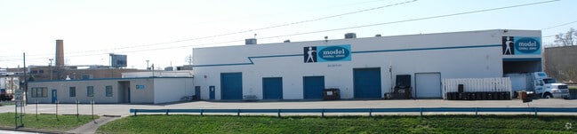
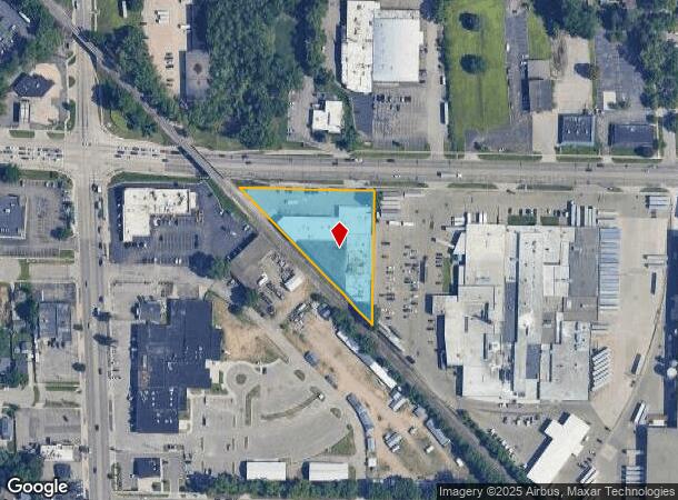
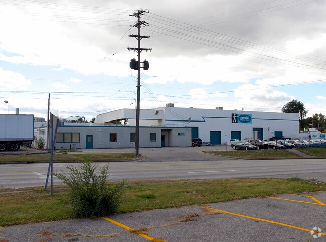
Property Record
100 28Th St Se, Grand Rapids, MI 49548
NEARBY LISTINGS FOR SALE OR LEASE
Property Detail
100 28Th St Se
Grand Rapids-Wyoming, MI
Pennell Park #1
41-18-18-126-001
LOT 1 ALSO THAT PART OF LOTS 2, 3, 4 & 5 BLK 17 & OF VACATED PORTION OF MAITLAND AVE LYING W OF A LINE DRAWN FROM A PT ON S
Manufacturinglight
Kent
X
Michigan
26081C0416D
1-5
2024
1.37 AC
2025
S Grand Rapids/Kentwood
004100
West Michigan
42,954 SF
DEMOGRAPHICS near 100 28Th St Se
1 Mile
3 Mile
5 Mile
2024 Total Population
11,971
128,063
287,172
2029 Population
11,966
128,657
288,809
Pop Growth 2024-2029
(0.04%)
+ 0.46%
+ 0.57%
Average Age
36
36
36
2024 Total Households
4,166
46,005
111,292
HH Growth 2024-2029
+ 0.02%
+ 0.50%
+ 0.64%
Median Household Inc
$64,704
$57,800
$61,696
Avg Household Size
2.80
2.70
2.50
2024 Avg HH Vehicles
2.00
2.00
2.00
Median Home Value
$166,060
$167,500
$200,977
Median Year Built
1950
1956
1963
Nearby Places
Map Layers
Map Styles
 Street
 Aerial
- Restaurants
- Banks
- Shops
- Fitness
- Groceries
PUBLIC TRANSPORTATION
COMMUTER RAIL
Grand Rapids Vernon J. Ehlers Station (Pere Marquette - Amtrak)
DRIVE
WALK
Distance
Grand Rapids Vernon J. Ehlers Station (Pere Marquette - Amtrak)
6 min
4.2 mi
AIRPORT
Gerald R Ford International
DRIVE
WALK
Distance
Gerald R Ford International
19 min
9.7 mi
Freight Ports
Port Milwaukee
DRIVE
WALK
Distance
Port Milwaukee
305 min
261.0 mi
Nearby Properties
Address
Land Use
TOTAL SIZE
Lot Size
Zoning
Address
Land Use
TOTAL SIZE
Lot Size
Zoning
649,177 SF
55.67 AC
SD-IT
Address
Land Use
TOTAL SIZE
Lot Size
Zoning
941,968 SF
38.56 AC
SD-IT
Address
Land Use
TOTAL SIZE
Lot Size
Zoning
398,607 SF
33.51 AC
R4
Address
Land Use
TOTAL SIZE
Lot Size
Zoning
1,426,319 SF
54.81 AC
SD-IT
Address
Land Use
TOTAL SIZE
Lot Size
Zoning
87.39 AC
I2
Address
Land Use
TOTAL SIZE
Lot Size
Zoning
264,739 SF
26.56 AC
I2
Address
Land Use
TOTAL SIZE
Lot Size
Zoning
13.71 AC
MCN-LDR
Address
Land Use
TOTAL SIZE
Lot Size
Zoning
536,296 SF
26.16 AC
SD-IT
Address
Land Use
TOTAL SIZE
Lot Size
Zoning
179,436 SF
24.94 AC
I2
Address
Land Use
TOTAL SIZE
Lot Size
Zoning
348,367 SF
12.15 AC
SD-IT
Address
Land Use
TOTAL SIZE
Lot Size
Zoning
29.13 AC
Address
Land Use
TOTAL SIZE
Lot Size
Zoning
251,562 SF
15.56 AC
MZ
Address
Land Use
TOTAL SIZE
Lot Size
Zoning
162,228 SF
14.31 AC
R4
Address
Land Use
TOTAL SIZE
Lot Size
Zoning
136,112 SF
17.63 AC
MON-C
Address
Land Use
TOTAL SIZE
Lot Size
Zoning
Address
Land Use
TOTAL SIZE
Lot Size
Zoning
349,885 SF
8.92 AC
I1
Address
Land Use
TOTAL SIZE
Lot Size
Zoning
174,256 SF
10.83 AC
SD-IT
Address
Land Use
TOTAL SIZE
Lot Size
Zoning
248,360 SF
7.03 AC
SD-IT
Address
Land Use
TOTAL SIZE
Lot Size
Zoning
123,517 SF
15.71 AC
MON-C
Address
Land Use
TOTAL SIZE
Lot Size
Zoning
157,386 SF
13.11 AC
R4
Address
Land Use
TOTAL SIZE
Lot Size
Zoning
442,193 SF
17.90 AC
I1
Address
Land Use
TOTAL SIZE
Lot Size
Zoning
116,832 SF
14.32 AC
R4
Address
Land Use
TOTAL SIZE
Lot Size
Zoning
260,000 SF
10.49 AC
SD-IT
Address
Land Use
TOTAL SIZE
Lot Size
Zoning
6.37 AC
MCN-MDR
Address
Land Use
TOTAL SIZE
Lot Size
Zoning
50.15 AC
Address
Land Use
TOTAL SIZE
Lot Size
Zoning
203,567 SF
17.48 AC
I2
Address
Land Use
TOTAL SIZE
Lot Size
Zoning
192,852 SF
4.27 AC
MON-MDR
Address
Land Use
TOTAL SIZE
Lot Size
Zoning
137,114 SF
12.50 AC
R4
Address
Land Use
TOTAL SIZE
Lot Size
Zoning
58,067 SF
4.15 AC
TN-LDR
Address
Land Use
TOTAL SIZE
Lot Size
Zoning
143,447 SF
10.72 AC
R4
The World's #1 Commercial Real Estate Marketplace
Connect with us
© 2025 CoStar Group
The information above has been obtained from sources believed reliable. While we do not doubt its accuracy we have not verified it and make no guarantee, warranty or representation about it. It is your responsibility to independently confirm its accuracy and completeness. Any projections, opinions, assumptions, or estimates used are for example only and do not represent the current or future performance of the property. The value of this transaction to you depends on tax and other factors which should be evaluated by your tax, financial, and legal advisors. You and your advisors should conduct a careful, independent investigation of the property to determine to your satisfaction the suitability of the property for your needs.