No Photo
Property Record
100 7Th Ave, Albany, GA 31701

NEARBY LISTINGS FOR SALE OR LEASE
Property Detail
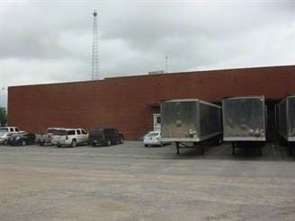
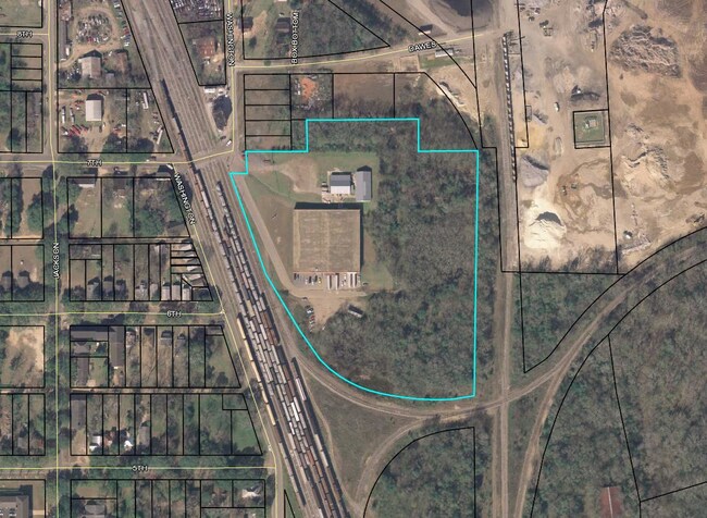
100 7Th Ave
000KK-00004-008
Ind-Route 91
Publicstorage
Dougherty
AE
Georgia
13095C0107E
14.60 AC
2024
Albany/Southwest
2024
Other Market Areas
011300
Albany, GA
43,183 SF
DEMOGRAPHICS near 100 7Th Ave
1 Mile
3 Mile
5 Mile
2024 Total Population
2,636
35,252
73,685
2029 Population
2,584
34,156
71,683
Pop Growth 2024-2029
(1.97%)
(3.11%)
(2.72%)
Average Age
40
38
38
2024 Total Households
1,159
14,804
30,258
HH Growth 2024-2029
(1.73%)
(3.20%)
(2.95%)
Median Household Inc
$34,021
$34,772
$42,992
Avg Household Size
2.10
2.30
2.30
2024 Avg HH Vehicles
1.00
1.00
1.00
Median Home Value
$107,812
$90,750
$118,555
Median Year Built
1963
1966
1975
Nearby Places
Map Layers
Map Styles
 Street
 Aerial
- Restaurants
- Banks
- Shops
- Fitness
- Groceries
PUBLIC TRANSPORTATION
AIRPORT
Southwest Georgia Regional
DRIVE
WALK
Distance
Southwest Georgia Regional
15 min
6.1 mi
Freight Ports
Port of Panama City
DRIVE
WALK
Distance
Port of Panama City
234 min
160.3 mi
SALE & LEASE HISTORY
LISTING DATE
SALE/LEASE

Sep 07, 2017
For Lease
Sep 07, 2017
For Sale
Sep 07, 2017
For Sale
Jun 05, 2017
For Lease
Jun 05, 2017
For Sale
Nearby Properties
Address
Land Use
TOTAL SIZE
Lot Size
Zoning
Address
Land Use
TOTAL SIZE
Lot Size
Zoning
Address
Land Use
TOTAL SIZE
Lot Size
Zoning
58.86 AC
C3
Address
Land Use
TOTAL SIZE
Lot Size
Zoning
51,008 SF
19.48 AC
C5
Address
Land Use
TOTAL SIZE
Lot Size
Zoning
274,484 SF
16.31 AC
C5
Address
Land Use
TOTAL SIZE
Lot Size
Zoning
1.77 AC
C2
Address
Land Use
TOTAL SIZE
Lot Size
Zoning
15.20 AC
C2
Address
Land Use
TOTAL SIZE
Lot Size
Zoning
250.69 AC
C5
Address
Land Use
TOTAL SIZE
Lot Size
Zoning
2.53 AC
C2
Address
Land Use
TOTAL SIZE
Lot Size
Zoning
1.75 AC
C2
Address
Land Use
TOTAL SIZE
Lot Size
Zoning
0.83 AC
C2
Address
Land Use
TOTAL SIZE
Lot Size
Zoning
77,688 SF
2.93 AC
C3
Address
Land Use
TOTAL SIZE
Lot Size
Zoning
70,596 SF
2.38 AC
C2
Address
Land Use
TOTAL SIZE
Lot Size
Zoning
382,331 SF
30.50 AC
M1
Address
Land Use
TOTAL SIZE
Lot Size
Zoning
0.54 AC
C2
Address
Land Use
TOTAL SIZE
Lot Size
Zoning
21,144 SF
11.79 AC
R6
Address
Land Use
TOTAL SIZE
Lot Size
Zoning
8 AC
M1
Address
Land Use
TOTAL SIZE
Lot Size
Zoning
475,976 SF
51.30 AC
M1
Address
Land Use
TOTAL SIZE
Lot Size
Zoning
0.52 AC
C2
Address
Land Use
TOTAL SIZE
Lot Size
Zoning
98,560 SF
19.64 AC
R6
Address
Land Use
TOTAL SIZE
Lot Size
Zoning
82,944 SF
8.10 AC
R6
Address
Land Use
TOTAL SIZE
Lot Size
Zoning
25,777 SF
9.30 AC
C3
Address
Land Use
TOTAL SIZE
Lot Size
Zoning
13,958 SF
15 AC
M1
Address
Land Use
TOTAL SIZE
Lot Size
Zoning
28,713 SF
9.96 AC
C3
Address
Land Use
TOTAL SIZE
Lot Size
Zoning
30,336 SF
19.19 AC
R6
Address
Land Use
TOTAL SIZE
Lot Size
Zoning
66,382 SF
14.64 AC
COMMERCIAL
Address
Land Use
TOTAL SIZE
Lot Size
Zoning
10,608 SF
45.66 AC
M1
Address
Land Use
TOTAL SIZE
Lot Size
Zoning
127,194 SF
15.01 AC
C2
Address
Land Use
TOTAL SIZE
Lot Size
Zoning
89,370 SF
7.78 AC
Address
Land Use
TOTAL SIZE
Lot Size
Zoning
52,844 SF
18.09 AC
R6
Address
Land Use
TOTAL SIZE
Lot Size
Zoning
16,800 SF
4.76 AC
C2
The World's #1 Commercial Real Estate Marketplace
Connect with us
© 2025 CoStar Group
The information above has been obtained from sources believed reliable. While we do not doubt its accuracy we have not verified it and make no guarantee, warranty or representation about it. It is your responsibility to independently confirm its accuracy and completeness. Any projections, opinions, assumptions, or estimates used are for example only and do not represent the current or future performance of the property. The value of this transaction to you depends on tax and other factors which should be evaluated by your tax, financial, and legal advisors. You and your advisors should conduct a careful, independent investigation of the property to determine to your satisfaction the suitability of the property for your needs.