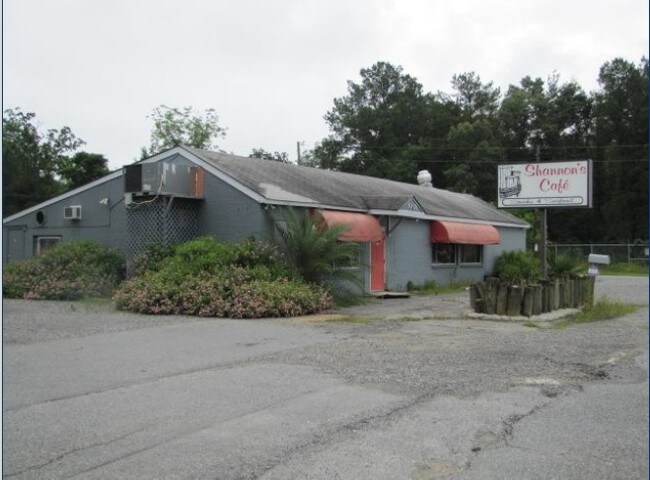
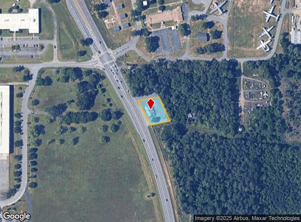
Property Record
100-A Highway 247 S, Warner Robins, GA 31088
NEARBY LISTINGS FOR SALE OR LEASE
Property Detail
100-A Highway 247 S
Warner Robins, GA
Hwy 247 500 Ff
0W0750019000
BEATRICE MARSHALL PROPERTY PB 4/174
Restaurantbuilding
Houston
X
Georgia
13289C0200B
242
2024
0.54 AC
2024
Perry/Warner Robins
021119
Other Market Areas
2,496 SF
DEMOGRAPHICS near 100-A Highway 247 S
1 Mile
3 Mile
5 Mile
2024 Total Population
1,389
24,419
75,881
2029 Population
1,539
26,919
83,381
Pop Growth 2024-2029
+ 10.80%
+ 10.24%
+ 9.88%
Average Age
28
37
37
2024 Total Households
403
9,533
29,266
HH Growth 2024-2029
+ 11.41%
+ 10.18%
+ 9.72%
Median Household Inc
$49,285
$65,340
$64,550
Avg Household Size
2.70
2.40
2.50
2024 Avg HH Vehicles
2.00
2.00
2.00
Median Home Value
$107,500
$158,845
$161,201
Median Year Built
1995
1983
1984
Nearby Places
Map Layers
Map Styles
 Street
 Aerial
- Restaurants
- Banks
- Shops
- Fitness
- Groceries
Nearby Properties
Address
Land Use
TOTAL SIZE
Lot Size
Zoning
Address
Land Use
TOTAL SIZE
Lot Size
Zoning
88,965 SF
18.72 AC
R2
Address
Land Use
TOTAL SIZE
Lot Size
Zoning
100,320 SF
26.91 AC
C2
Address
Land Use
TOTAL SIZE
Lot Size
Zoning
178,400 SF
49.03 AC
R2
Address
Land Use
TOTAL SIZE
Lot Size
Zoning
3,199 SF
41.42 AC
R4
Address
Land Use
TOTAL SIZE
Lot Size
Zoning
842,179 SF
101.75 AC
M2
Address
Land Use
TOTAL SIZE
Lot Size
Zoning
210,408 SF
47.18 AC
C2
Address
Land Use
TOTAL SIZE
Lot Size
Zoning
19,200 SF
14.70 AC
R4
Address
Land Use
TOTAL SIZE
Lot Size
Zoning
17,832 SF
13.60 AC
R4
Address
Land Use
TOTAL SIZE
Lot Size
Zoning
120,000 SF
19.03 AC
R3
Address
Land Use
TOTAL SIZE
Lot Size
Zoning
93,450 SF
11.16 AC
R2
Address
Land Use
TOTAL SIZE
Lot Size
Zoning
100,000 SF
12.12 AC
RAG
Address
Land Use
TOTAL SIZE
Lot Size
Zoning
60,000 SF
8.95 AC
C3
Address
Land Use
TOTAL SIZE
Lot Size
Zoning
48,462 SF
5.54 AC
C2
Address
Land Use
TOTAL SIZE
Lot Size
Zoning
25,062 SF
R4
Address
Land Use
TOTAL SIZE
Lot Size
Zoning
25,062 SF
R4
Address
Land Use
TOTAL SIZE
Lot Size
Zoning
1,512 SF
309.01 AC
M2
Address
Land Use
TOTAL SIZE
Lot Size
Zoning
71,434 SF
10.58 AC
R2
Address
Land Use
TOTAL SIZE
Lot Size
Zoning
60,120 SF
13.97 AC
R2
Address
Land Use
TOTAL SIZE
Lot Size
Zoning
75,613 SF
11.51 AC
C1
Address
Land Use
TOTAL SIZE
Lot Size
Zoning
22,500 SF
9.80 AC
R2
Address
Land Use
TOTAL SIZE
Lot Size
Zoning
5,412 SF
4.98 AC
R4
Address
Land Use
TOTAL SIZE
Lot Size
Zoning
102,400 SF
28.22 AC
M2
Address
Land Use
TOTAL SIZE
Lot Size
Zoning
65,700 SF
5.48 AC
C3
Address
Land Use
TOTAL SIZE
Lot Size
Zoning
45,978 SF
6.97 AC
C3
Address
Land Use
TOTAL SIZE
Lot Size
Zoning
15,944 SF
32.92 AC
R2
Address
Land Use
TOTAL SIZE
Lot Size
Zoning
2,100 SF
13.54 AC
R4
Address
Land Use
TOTAL SIZE
Lot Size
Zoning
36,016 SF
2.11 AC
R2
Address
Land Use
TOTAL SIZE
Lot Size
Zoning
6,988 SF
3.66 AC
R4
Address
Land Use
TOTAL SIZE
Lot Size
Zoning
60,126 SF
13.08 AC
C2
Address
Land Use
TOTAL SIZE
Lot Size
Zoning
40,050 SF
7.63 AC
M1
The World's #1 Commercial Real Estate Marketplace
Connect with us
© 2025 CoStar Group
The information above has been obtained from sources believed reliable. While we do not doubt its accuracy we have not verified it and make no guarantee, warranty or representation about it. It is your responsibility to independently confirm its accuracy and completeness. Any projections, opinions, assumptions, or estimates used are for example only and do not represent the current or future performance of the property. The value of this transaction to you depends on tax and other factors which should be evaluated by your tax, financial, and legal advisors. You and your advisors should conduct a careful, independent investigation of the property to determine to your satisfaction the suitability of the property for your needs.