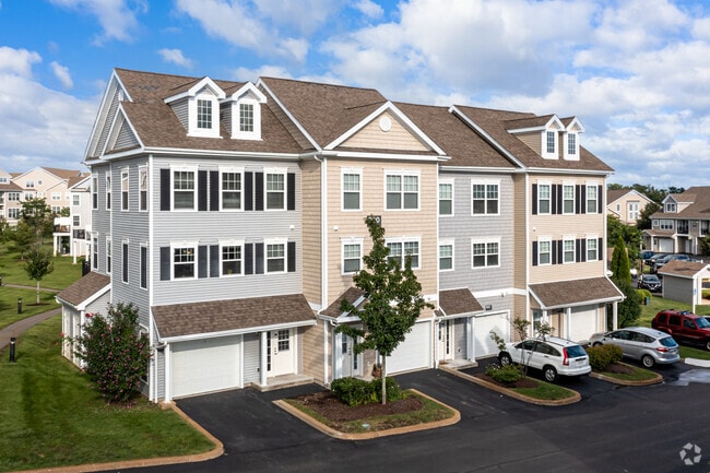
Property Record
100 Avalon Dr, Cohasset, MA 02025
NEARBY LISTINGS FOR SALE OR LEASE
Property Detail
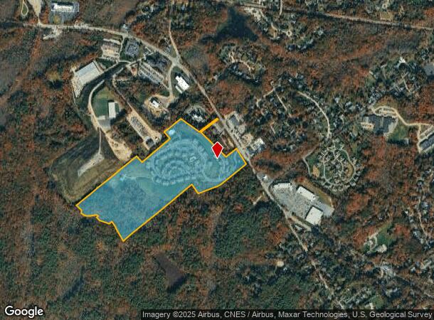
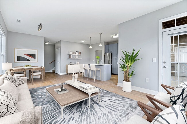
100 Avalon Dr
COHA-000006C-000072-000004
Norfolk
Apartment
Massachusetts
X
4
25021C0252G
42.93 AC
2025
Cohasset
2025
Boston
423101
Boston-Cambridge-Newton, MA-NH
94,532 SF
DEMOGRAPHICS near 100 Avalon Dr
1 Mile
3 Mile
5 Mile
2024 Total Population
2,323
17,821
54,645
2029 Population
2,311
17,912
55,260
Pop Growth 2024-2029
(0.52%)
+ 0.51%
+ 1.13%
Average Age
41
43
43
2024 Total Households
861
6,877
20,568
HH Growth 2024-2029
(0.46%)
+ 0.58%
+ 1.19%
Median Household Inc
$188,888
$159,670
$160,545
Avg Household Size
2.70
2.60
2.60
2024 Avg HH Vehicles
2.00
2.00
2.00
Median Home Value
$917,430
$901,514
$817,206
Median Year Built
1967
1963
1962
Nearby Places
Map Layers
Map Styles
 Street
 Aerial
- Restaurants
- Banks
- Shops
- Fitness
- Groceries
PUBLIC TRANSPORTATION
COMMUTER RAIL
Cohasset (Greenbush Line - Massachusetts Bay Transportation Authority Commuter Rail (Purple Line))
DRIVE
WALK
Distance
Cohasset (Greenbush Line - Massachusetts Bay Transportation Authority Commuter Rail (Purple Line))
2 min
1.3 mi
Nantasket Junction (Greenbush Line - Massachusetts Bay Transportation Authority Commuter Rail (Purple Line))
DRIVE
WALK
Distance
Nantasket Junction (Greenbush Line - Massachusetts Bay Transportation Authority Commuter Rail (Purple Line))
5 min
2.9 mi
AIRPORT
General Edward Lawrence Logan International
DRIVE
WALK
Distance
General Edward Lawrence Logan International
38 min
21.2 mi
Freight Ports
Port of Boston
DRIVE
WALK
Distance
Port of Boston
36 min
19.1 mi
Nearby Properties
Address
Land Use
TOTAL SIZE
Lot Size
Zoning
Address
Land Use
TOTAL SIZE
Lot Size
Zoning
193,216 SF
11.98 AC
MFA
Address
Land Use
TOTAL SIZE
Lot Size
Zoning
80.40 AC
N/A
Address
Land Use
TOTAL SIZE
Lot Size
Zoning
177,187 SF
49.76 AC
Address
Land Use
TOTAL SIZE
Lot Size
Zoning
90,325 SF
11.64 AC
Address
Land Use
TOTAL SIZE
Lot Size
Zoning
205,836 SF
18 AC
RB
Address
Land Use
TOTAL SIZE
Lot Size
Zoning
527 AC
RC
Address
Land Use
TOTAL SIZE
Lot Size
Zoning
7.93 AC
RC
Address
Land Use
TOTAL SIZE
Lot Size
Zoning
89,648 SF
14.88 AC
RB
Address
Land Use
TOTAL SIZE
Lot Size
Zoning
13.46 AC
TECH
Address
Land Use
TOTAL SIZE
Lot Size
Zoning
68,507 SF
2.90 AC
TECH
Address
Land Use
TOTAL SIZE
Lot Size
Zoning
32,108 SF
1.23 AC
RB
Address
Land Use
TOTAL SIZE
Lot Size
Zoning
861 AC
OS
Address
Land Use
TOTAL SIZE
Lot Size
Zoning
63,372 SF
5.02 AC
LI
Address
Land Use
TOTAL SIZE
Lot Size
Zoning
11,621 SF
9.25 AC
RB
Address
Land Use
TOTAL SIZE
Lot Size
Zoning
19,146 SF
122.83 AC
RC
Address
Land Use
TOTAL SIZE
Lot Size
Zoning
625.05 AC
Address
Land Use
TOTAL SIZE
Lot Size
Zoning
57,053 SF
2.44 AC
Address
Land Use
TOTAL SIZE
Lot Size
Zoning
7.68 AC
HB
Address
Land Use
TOTAL SIZE
Lot Size
Zoning
36,446 SF
5.49 AC
TECH
Address
Land Use
TOTAL SIZE
Lot Size
Zoning
71,924 SF
15.41 AC
RB
Address
Land Use
TOTAL SIZE
Lot Size
Zoning
5.40 AC
RC
Address
Land Use
TOTAL SIZE
Lot Size
Zoning
45,023 SF
4.60 AC
TECH
Address
Land Use
TOTAL SIZE
Lot Size
Zoning
8,214 SF
1.96 AC
Address
Land Use
TOTAL SIZE
Lot Size
Zoning
27,434 SF
6.02 AC
Address
Land Use
TOTAL SIZE
Lot Size
Zoning
11,301 SF
6.17 AC
POS
Address
Land Use
TOTAL SIZE
Lot Size
Zoning
12,950 SF
0.55 AC
CRB
Address
Land Use
TOTAL SIZE
Lot Size
Zoning
61,416 SF
4.63 AC
HB
Address
Land Use
TOTAL SIZE
Lot Size
Zoning
5.78 AC
RC
Address
Land Use
TOTAL SIZE
Lot Size
Zoning
11,405 SF
7.90 AC
RC
The World's #1 Commercial Real Estate Marketplace
Connect with us
© 2026 CoStar Group
The information above has been obtained from sources believed reliable. While we do not doubt its accuracy we have not verified it and make no guarantee, warranty or representation about it. It is your responsibility to independently confirm its accuracy and completeness. Any projections, opinions, assumptions, or estimates used are for example only and do not represent the current or future performance of the property. The value of this transaction to you depends on tax and other factors which should be evaluated by your tax, financial, and legal advisors. You and your advisors should conduct a careful, independent investigation of the property to determine to your satisfaction the suitability of the property for your needs.