Property Record
100 Barnes Rd, Wallingford, CT 06492
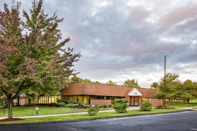

Property Detail
100 Barnes Rd
WALL-000051-000000-000008
South Central Ct
Governmentalpublicusegeneral
Connecticut
IX
8
B and X Area of moderate flood hazard, usually the area between the limits of the 100-year and 500-year floods.
9.22 AC
2025
Wallingford
2025
Westchester/So Connecticut
175800
New Haven, CT
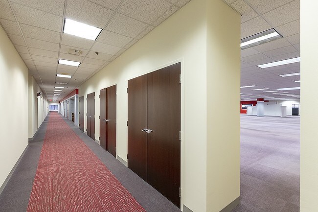
43,617 SF
NEARBY LISTINGS FOR SALE OR LEASE
DEMOGRAPHICS near 100 Barnes Rd
1 mile
3 mile
5 mile
2025 Total Population
1,780
47,253
111,089
2030 Population
1,784
47,547
112,062
Pop Growth 2025-2030
+ 0.22%
+ 0.62%
+ 0.88%
Average Age
42
43
42
2025 Total Households
700
19,106
44,248
HH Growth 2025-2030
0.00%
+ 0.53%
+ 0.83%
Median Household Inc
$110,156
$91,002
$83,628
Avg Household Size
2.40
2.30
2.40
2025 Avg HH Vehicles
2.00
2.00
2.00
Median Home Value
$367,599
$300,176
$296,878
Median Year Built
1976
1967
1964
Nearby Places
Map Layers
Map Styles
 Street
 Aerial
Transit
 Traffic
 Biking
Places
Listings with unknown addresses are not visible on the map
- Restaurants
- Banks
- Shops
- Fitness
- Groceries
PUBLIC TRANSPORTATION
COMMUTER RAIL
Drive
Walk
Distance
6 min
2.5 mi
Drive
Walk
Distance
6 min
2.8 mi
AIRPORT
Tweed/New Haven
Drive
Walk
Distance
Tweed/New Haven
31 min
18.4 mi
Bradley International
Drive
Walk
Distance
Bradley International
61 min
40.2 mi
SALE & LEASE HISTORY
LISTING DATE
SALE/LEASE

Sep 25, 2020
For Sale
Sep 25, 2020
For Lease
Oct 18, 2018
For Sale
Oct 16, 2017
For Lease
Nearby Properties
Address
Land Use
TOTAL SIZE
Lot Size
Zoning
Address
Land Use
TOTAL SIZE
Lot Size
Zoning
63,356 SF
154.26 AC
RM40
Address
Land Use
TOTAL SIZE
Lot Size
Zoning
2,400 SF
38.29 AC
M-3
Address
Land Use
TOTAL SIZE
Lot Size
Zoning
32.85 AC
RU40
Address
Land Use
TOTAL SIZE
Lot Size
Zoning
105,252 SF
9.13 AC
I40
Address
Land Use
TOTAL SIZE
Lot Size
Zoning
34.10 AC
C-3
Address
Land Use
TOTAL SIZE
Lot Size
Zoning
44.46 AC
R18
Address
Land Use
TOTAL SIZE
Lot Size
Zoning
329,296 SF
35.55 AC
IX
Address
Land Use
TOTAL SIZE
Lot Size
Zoning
339,844 SF
52.43 AC
M-4
Address
Land Use
TOTAL SIZE
Lot Size
Zoning
291,405 SF
104.81 AC
WI
Address
Land Use
TOTAL SIZE
Lot Size
Zoning
119,598 SF
18.43 AC
RF40
Address
Land Use
TOTAL SIZE
Lot Size
Zoning
23,920 SF
137.43 AC
R18
Address
Land Use
TOTAL SIZE
Lot Size
Zoning
11.02 AC
S-R
Address
Land Use
TOTAL SIZE
Lot Size
Zoning
172,027 SF
18.04 AC
RF40
Address
Land Use
TOTAL SIZE
Lot Size
Zoning
72,256 SF
R18
Address
Land Use
TOTAL SIZE
Lot Size
Zoning
13.42 AC
RM6
Address
Land Use
TOTAL SIZE
Lot Size
Zoning
26.45 AC
RF40
Address
Land Use
TOTAL SIZE
Lot Size
Zoning
187,914 SF
16.13 AC
IX
Address
Land Use
TOTAL SIZE
Lot Size
Zoning
38,735 SF
Address
Land Use
TOTAL SIZE
Lot Size
Zoning
123,730 SF
40.31 AC
R18
Address
Land Use
TOTAL SIZE
Lot Size
Zoning
203,692 SF
21.22 AC
IX
Address
Land Use
TOTAL SIZE
Lot Size
Zoning
22,284 SF
128.20 AC
RU40
Address
Land Use
TOTAL SIZE
Lot Size
Zoning
18.70 AC
RF40
Address
Land Use
TOTAL SIZE
Lot Size
Zoning
166,724 SF
21.79 AC
M-2
Address
Land Use
TOTAL SIZE
Lot Size
Zoning
12 AC
RU40
Address
Land Use
TOTAL SIZE
Lot Size
Zoning
8,984 SF
22.75 AC
RM11
Address
Land Use
TOTAL SIZE
Lot Size
Zoning
9.75 AC
RF40
Address
Land Use
TOTAL SIZE
Lot Size
Zoning
48,942 SF
6.74 AC
RF40
Address
Land Use
TOTAL SIZE
Lot Size
Zoning
19.47 AC
RF40
Address
Land Use
TOTAL SIZE
Lot Size
Zoning
60,834 SF
3.61 AC
CLB
Address
Land Use
TOTAL SIZE
Lot Size
Zoning
34,021 SF
R18
The World's #1 Commercial Real Estate Marketplace
Connect with us
© 2026 CoStar Group
The information above has been obtained from sources believed reliable. While we do not doubt its accuracy we have not verified it and make no guarantee, warranty or representation about it. It is your responsibility to independently confirm its accuracy and completeness. Any projections, opinions, assumptions, or estimates used are for example only and do not represent the current or future performance of the property. The value of this transaction to you depends on tax and other factors which should be evaluated by your tax, financial, and legal advisors. You and your advisors should conduct a careful, independent investigation of the property to determine to your satisfaction the suitability of the property for your needs.