Property Record
100 Boston Rd, Groton, MA 01450

Save to a Folder
{{folder.Name}}
{{folder.ListingIds.length}} Properties
{{folder.ListingIds.length}} Property
Create a New Folder
This Property Is For Sale
Property Detail
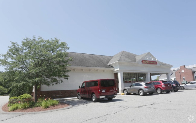
100 Boston Rd
GROT-000222-000019
Middlesex
Commercialnec
Massachusetts
B1
9 AC
B and X Area of moderate flood hazard, usually the area between the limits of the 100-year and 500-year floods.
Groton/Townsend
2025
Boston
2025
Boston-Cambridge-Newton, MA-NH
326101
NEARBY LISTINGS FOR SALE OR LEASE
DEMOGRAPHICS near 100 Boston Rd
1 mile
3 mile
5 mile
2025 Total Population
865
13,502
40,538
2030 Population
902
14,131
42,263
Pop Growth 2025-2030
+ 4.28%
+ 4.66%
+ 4.26%
Average Age
42
42
42
2025 Total Households
305
5,089
14,985
HH Growth 2025-2030
+ 4.26%
+ 4.83%
+ 4.46%
Median Household Inc
$208,125
$138,124
$138,841
Avg Household Size
2.70
2.50
2.60
2025 Avg HH Vehicles
2.00
2.00
2.00
Median Home Value
$773,223
$637,294
$614,642
Median Year Built
1985
1981
1981
Nearby Places
Map Layers
Map Styles
 Street
 Aerial
Layers
 Traffic
 Biking
Places
Listings with unknown addresses are not visible on the map
- Restaurants
- Banks
- Shops
- Fitness
- Groceries
PUBLIC TRANSPORTATION
COMMUTER RAIL
Ayer (Fitchburg/South Acton Line - Massachusetts Bay Transportation Authority Commuter Rail (Purple Line))
Drive
Walk
Distance
Ayer (Fitchburg/South Acton Line - Massachusetts Bay Transportation Authority Commuter Rail (Purple Line))
10 min
4.6 mi
Shirley (Fitchburg/South Acton Line - Massachusetts Bay Transportation Authority Commuter Rail (Purple Line))
Drive
Walk
Distance
Shirley (Fitchburg/South Acton Line - Massachusetts Bay Transportation Authority Commuter Rail (Purple Line))
15 min
7.2 mi
AIRPORT
Manchester Boston Regional
Drive
Walk
Distance
Manchester Boston Regional
52 min
29.4 mi
Worcester Regional
Drive
Walk
Distance
Worcester Regional
56 min
39.5 mi
Freight Ports
Port of Boston
Drive
Walk
Distance
Port of Boston
62 min
37.5 mi
Nearby Properties
Address
Land Use
TOTAL SIZE
Lot Size
Zoning
Address
Land Use
TOTAL SIZE
Lot Size
Zoning
329,818 SF
55 AC
A1
Address
Land Use
TOTAL SIZE
Lot Size
Zoning
35.63 AC
O
Address
Land Use
TOTAL SIZE
Lot Size
Zoning
51,888 SF
57.38 AC
LI
Address
Land Use
TOTAL SIZE
Lot Size
Zoning
28 AC
RA
Address
Land Use
TOTAL SIZE
Lot Size
Zoning
15.98 AC
O
Address
Land Use
TOTAL SIZE
Lot Size
Zoning
213,950 SF
22.71 AC
I
Address
Land Use
TOTAL SIZE
Lot Size
Zoning
293,250 SF
60.10 AC
LI
Address
Land Use
TOTAL SIZE
Lot Size
Zoning
343,400 SF
20 AC
LI
Address
Land Use
TOTAL SIZE
Lot Size
Zoning
105,559 SF
35.45 AC
A1
Address
Land Use
TOTAL SIZE
Lot Size
Zoning
8.44 AC
B1
Address
Land Use
TOTAL SIZE
Lot Size
Zoning
14.90 AC
RA
Address
Land Use
TOTAL SIZE
Lot Size
Zoning
6.50 AC
RA
Address
Land Use
TOTAL SIZE
Lot Size
Zoning
94,159 SF
13.31 AC
I
Address
Land Use
TOTAL SIZE
Lot Size
Zoning
58,738 SF
183.84 AC
RA
Address
Land Use
TOTAL SIZE
Lot Size
Zoning
130 AC
RA
Address
Land Use
TOTAL SIZE
Lot Size
Zoning
49,689 SF
3.67 AC
GB
Address
Land Use
TOTAL SIZE
Lot Size
Zoning
160,860 SF
5.81 AC
I
Address
Land Use
TOTAL SIZE
Lot Size
Zoning
20,102 SF
1.26 AC
DB
Address
Land Use
TOTAL SIZE
Lot Size
Zoning
133,239 SF
12.12 AC
I
Address
Land Use
TOTAL SIZE
Lot Size
Zoning
96,036 SF
9.82 AC
I
Address
Land Use
TOTAL SIZE
Lot Size
Zoning
54,526 SF
1.84 AC
A2
Address
Land Use
TOTAL SIZE
Lot Size
Zoning
14,700 SF
0.75 AC
DB
Address
Land Use
TOTAL SIZE
Lot Size
Zoning
115,352 SF
6.78 AC
I
Address
Land Use
TOTAL SIZE
Lot Size
Zoning
16.66 AC
RA
Address
Land Use
TOTAL SIZE
Lot Size
Zoning
107,452 SF
5.35 AC
I
Address
Land Use
TOTAL SIZE
Lot Size
Zoning
39,510 SF
3.79 AC
GB
Address
Land Use
TOTAL SIZE
Lot Size
Zoning
91,580 SF
6.67 AC
I
Address
Land Use
TOTAL SIZE
Lot Size
Zoning
62,372 SF
6.18 AC
LI
Address
Land Use
TOTAL SIZE
Lot Size
Zoning
36,400 SF
4.26 AC
A2
Address
Land Use
TOTAL SIZE
Lot Size
Zoning
13,786 SF
2.79 AC
RA
The World's #1 Commercial Real Estate Marketplace
Connect with us
© 2026 CoStar Group
The information above has been obtained from sources believed reliable. While we do not doubt its accuracy we have not verified it and make no guarantee, warranty or representation about it. It is your responsibility to independently confirm its accuracy and completeness. Any projections, opinions, assumptions, or estimates used are for example only and do not represent the current or future performance of the property. The value of this transaction to you depends on tax and other factors which should be evaluated by your tax, financial, and legal advisors. You and your advisors should conduct a careful, independent investigation of the property to determine to your satisfaction the suitability of the property for your needs.