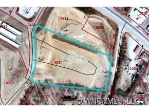
Property Record
100 Boxelder Cir, Asheville, NC 28806


NEARBY LISTINGS FOR SALE OR LEASE
Property Detail
100 Boxelder Cir
Asheville, NC
Mt Carmel Properties Llc
9629-07-6381-00000
SUBDIV: MT CARMEL PROPERTIES LLC BLOCK: LOT: LOT 2 SECTION: PLAT: 0115-0134
Governmentalpublicusegeneral
Buncombe
X
North Carolina
3700962900J
2
0
4.33 AC
2025
Buncombe County
002608
Asheville
23,372 SF
DEMOGRAPHICS near 100 Boxelder Cir
1 Mile
3 Mile
5 Mile
2024 Total Population
4,324
30,599
85,584
2029 Population
4,492
31,708
88,795
Pop Growth 2024-2029
+ 3.89%
+ 3.62%
+ 3.75%
Average Age
39
39
41
2024 Total Households
1,835
12,651
36,214
HH Growth 2024-2029
+ 3.43%
+ 3.06%
+ 3.29%
Median Household Inc
$59,848
$52,846
$60,768
Avg Household Size
2.30
2.30
2.20
2024 Avg HH Vehicles
2.00
2.00
2.00
Median Home Value
$237,198
$256,436
$337,973
Median Year Built
1993
1985
1979
Nearby Places
Map Layers
Map Styles
 Street
 Aerial
- Restaurants
- Banks
- Shops
- Fitness
- Groceries
PUBLIC TRANSPORTATION
AIRPORT
Asheville Regional
DRIVE
WALK
Distance
Asheville Regional
25 min
16.2 mi
Freight Ports
North Charleston Terminal
DRIVE
WALK
Distance
North Charleston Terminal
296 min
259.9 mi
Nearby Properties
Address
Land Use
TOTAL SIZE
Lot Size
Zoning
Address
Land Use
TOTAL SIZE
Lot Size
Zoning
285,416 SF
98.33 AC
PS
Address
Land Use
TOTAL SIZE
Lot Size
Zoning
311,958 SF
33.93 AC
OU
Address
Land Use
TOTAL SIZE
Lot Size
Zoning
100,612 SF
16.84 AC
NS
Address
Land Use
TOTAL SIZE
Lot Size
Zoning
106,436 SF
22.02 AC
PS
Address
Land Use
TOTAL SIZE
Lot Size
Zoning
97,263 SF
17.50 AC
INST
Address
Land Use
TOTAL SIZE
Lot Size
Zoning
76,459 SF
7.01 AC
RM8
Address
Land Use
TOTAL SIZE
Lot Size
Zoning
72,413 SF
18.25 AC
RM16
Address
Land Use
TOTAL SIZE
Lot Size
Zoning
44,566 SF
7.39 AC
RM8
Address
Land Use
TOTAL SIZE
Lot Size
Zoning
55,153 SF
13.39 AC
RM16
Address
Land Use
TOTAL SIZE
Lot Size
Zoning
316,821 SF
23.88 AC
CI
Address
Land Use
TOTAL SIZE
Lot Size
Zoning
43,824 SF
13.71 AC
R-3
Address
Land Use
TOTAL SIZE
Lot Size
Zoning
145,519 SF
10.75 AC
R-2
Address
Land Use
TOTAL SIZE
Lot Size
Zoning
168,519 SF
53.11 AC
INST
Address
Land Use
TOTAL SIZE
Lot Size
Zoning
51,076 SF
6.53 AC
RM16
Address
Land Use
TOTAL SIZE
Lot Size
Zoning
87,857 SF
90.07 AC
INST
Address
Land Use
TOTAL SIZE
Lot Size
Zoning
82,535 SF
13.69 AC
HB
Address
Land Use
TOTAL SIZE
Lot Size
Zoning
96,028 SF
38.50 AC
PS
Address
Land Use
TOTAL SIZE
Lot Size
Zoning
149.65 AC
INST
Address
Land Use
TOTAL SIZE
Lot Size
Zoning
138,288 SF
17.37 AC
COMM EXP
Address
Land Use
TOTAL SIZE
Lot Size
Zoning
339,426 SF
12.49 AC
SHOPPING
Address
Land Use
TOTAL SIZE
Lot Size
Zoning
34,297 SF
5.31 AC
INST
Address
Land Use
TOTAL SIZE
Lot Size
Zoning
75,498 SF
11.12 AC
HR-6:TOWN
Address
Land Use
TOTAL SIZE
Lot Size
Zoning
122,214 SF
21.42 AC
HB
Address
Land Use
TOTAL SIZE
Lot Size
Zoning
97,200 SF
13.50 AC
LIGHT
Address
Land Use
TOTAL SIZE
Lot Size
Zoning
117,800 SF
14.17 AC
HB
Address
Land Use
TOTAL SIZE
Lot Size
Zoning
16,129 SF
61.10 AC
PS
Address
Land Use
TOTAL SIZE
Lot Size
Zoning
53,827 SF
19.79 AC
OB
Address
Land Use
TOTAL SIZE
Lot Size
Zoning
82,502 SF
8.77 AC
CS
Address
Land Use
TOTAL SIZE
Lot Size
Zoning
92,073 SF
24.92 AC
RM8
Address
Land Use
TOTAL SIZE
Lot Size
Zoning
99,500 SF
9.68 AC
IND
The World's #1 Commercial Real Estate Marketplace
Connect with us
© 2026 CoStar Group
The information above has been obtained from sources believed reliable. While we do not doubt its accuracy we have not verified it and make no guarantee, warranty or representation about it. It is your responsibility to independently confirm its accuracy and completeness. Any projections, opinions, assumptions, or estimates used are for example only and do not represent the current or future performance of the property. The value of this transaction to you depends on tax and other factors which should be evaluated by your tax, financial, and legal advisors. You and your advisors should conduct a careful, independent investigation of the property to determine to your satisfaction the suitability of the property for your needs.