Property Record
100 Brookdale Dr, Springfield, MA 01104
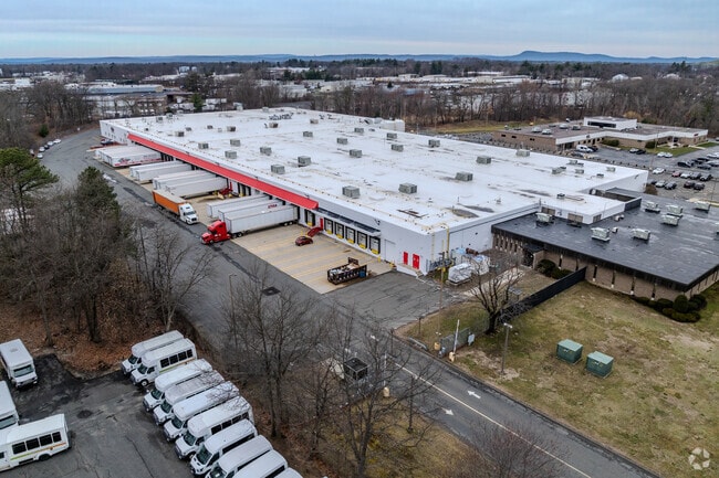
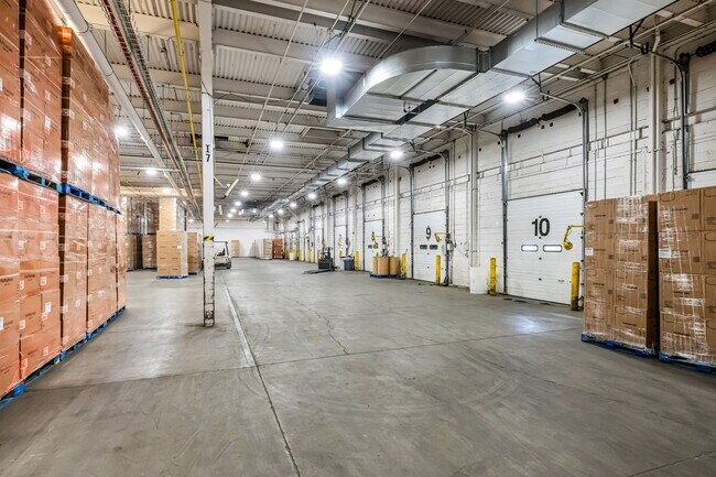
Property Detail
100 Brookdale Dr
Springfield, MA
HAMPDEN
SPRI-001953-000000-000030
Massachusetts
Commercialbuilding
14 AC
I2
Hampden County
B and X Area of moderate flood hazard, usually the area between the limits of the 100-year and 500-year floods.
Hartford
121,689 SF
NEARBY LISTINGS FOR SALE OR LEASE
DEMOGRAPHICS near 100 Brookdale Dr
1 mile
3 mile
5 mile
2025 Total Population
5,799
83,184
241,152
2030 Population
5,807
83,219
241,461
Pop Growth 2025-2030
+ 0.14%
+ 0.04%
+ 0.13%
Average Age
39
39
40
2025 Total Households
2,276
31,137
94,672
HH Growth 2025-2030
+ 0.13%
(0.06%)
+ 0.16%
Median Household Inc
$49,387
$60,545
$57,760
Avg Household Size
2.50
2.50
2.40
2025 Avg HH Vehicles
1.00
2.00
1.00
Median Home Value
$237,096
$259,469
$269,214
Median Year Built
1956
1955
1956
Nearby Places
Map Layers
Map Styles
 Street
 Aerial
Layers
 Traffic
 Biking
Places
Listings with unknown addresses are not visible on the map
- Restaurants
- Banks
- Shops
- Fitness
- Groceries
PUBLIC TRANSPORTATION
COMMUTER RAIL
Drive
Walk
Distance
10 min
5.5 mi
Drive
Walk
Distance
15 min
8.0 mi
AIRPORT
Bradley International
Drive
Walk
Distance
Bradley International
41 min
18.9 mi
Worcester Regional
Drive
Walk
Distance
Worcester Regional
70 min
47.9 mi
SALE & LEASE HISTORY
LISTING DATE
SALE/LEASE

Sep 25, 2016
For Lease
Sep 04, 2025
For Lease
Dec 27, 2018
For Lease
Nearby Properties
Address
Land Use
TOTAL SIZE
Lot Size
Zoning
Address
Land Use
TOTAL SIZE
Lot Size
Zoning
89,312 SF
38.72 AC
R1
Address
Land Use
TOTAL SIZE
Lot Size
Zoning
263,462 SF
21.65 AC
R2
Address
Land Use
TOTAL SIZE
Lot Size
Zoning
178,132 SF
15.60 AC
B1
Address
Land Use
TOTAL SIZE
Lot Size
Zoning
51,808 SF
11.01 AC
SR2B1
Address
Land Use
TOTAL SIZE
Lot Size
Zoning
48,924 SF
40.03 AC
I2
Address
Land Use
TOTAL SIZE
Lot Size
Zoning
431,476 SF
88.64 AC
SC2B1
Address
Land Use
TOTAL SIZE
Lot Size
Zoning
141,970 SF
4.34 AC
S
Address
Land Use
TOTAL SIZE
Lot Size
Zoning
56,576 SF
62.84 AC
SR1R4
Address
Land Use
TOTAL SIZE
Lot Size
Zoning
286,624 SF
17.40 AC
102
Address
Land Use
TOTAL SIZE
Lot Size
Zoning
7.41 AC
I2
Address
Land Use
TOTAL SIZE
Lot Size
Zoning
1.89 AC
SR2I2
Address
Land Use
TOTAL SIZE
Lot Size
Zoning
131,942 SF
40.30 AC
R1
Address
Land Use
TOTAL SIZE
Lot Size
Zoning
36,446 SF
25 AC
R1
Address
Land Use
TOTAL SIZE
Lot Size
Zoning
153,742 SF
22.34 AC
R1
Address
Land Use
TOTAL SIZE
Lot Size
Zoning
181,000 SF
34.48 AC
I1
Address
Land Use
TOTAL SIZE
Lot Size
Zoning
219,521 SF
7.50 AC
R2
Address
Land Use
TOTAL SIZE
Lot Size
Zoning
39,776 SF
8.16 AC
R2
Address
Land Use
TOTAL SIZE
Lot Size
Zoning
2,555 SF
166.42 AC
RB
Address
Land Use
TOTAL SIZE
Lot Size
Zoning
105,000 SF
17.59 AC
SR1R3
Address
Land Use
TOTAL SIZE
Lot Size
Zoning
762,340 SF
76.18 AC
SR1R2I
Address
Land Use
TOTAL SIZE
Lot Size
Zoning
29,464 SF
10.89 AC
R2
Address
Land Use
TOTAL SIZE
Lot Size
Zoning
99,792 SF
123.26 AC
S
Address
Land Use
TOTAL SIZE
Lot Size
Zoning
215,776 SF
28.52 AC
I1
Address
Land Use
TOTAL SIZE
Lot Size
Zoning
37,040 SF
4.50 AC
B1
Address
Land Use
TOTAL SIZE
Lot Size
Zoning
141,475 SF
31.69 AC
S
Address
Land Use
TOTAL SIZE
Lot Size
Zoning
11,115 SF
57.72 AC
R1
Address
Land Use
TOTAL SIZE
Lot Size
Zoning
62,115 SF
1.69 AC
R1
Address
Land Use
TOTAL SIZE
Lot Size
Zoning
15.31 AC
GB
Address
Land Use
TOTAL SIZE
Lot Size
Zoning
257,179 SF
22.84 AC
110
Address
Land Use
TOTAL SIZE
Lot Size
Zoning
6.81 AC
S
The World's #1 Commercial Real Estate Marketplace
Connect with us
© 2026 CoStar Group
The information above has been obtained from sources believed reliable. While we do not doubt its accuracy we have not verified it and make no guarantee, warranty or representation about it. It is your responsibility to independently confirm its accuracy and completeness. Any projections, opinions, assumptions, or estimates used are for example only and do not represent the current or future performance of the property. The value of this transaction to you depends on tax and other factors which should be evaluated by your tax, financial, and legal advisors. You and your advisors should conduct a careful, independent investigation of the property to determine to your satisfaction the suitability of the property for your needs.