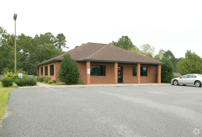
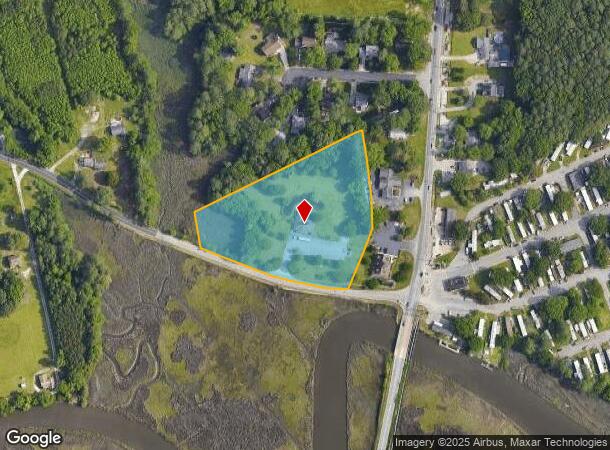
Property Record
100 Carys Chapel Rd, Poquoson, VA 23662
NEARBY LISTINGS FOR SALE OR LEASE
-
-
View all Poquoson listings for sale on LoopNet.com
Property Detail
100 Carys Chapel Rd
Virginia Beach-Norfolk-Newport News, VA-NC
3402 Census Tract
36-01-00-0008
PLAT OF PROP OF A M & JOHN L FIRTH 271/613
Commercialnec
Poquoson City
AE
Virginia
5155270003H
8
2025
4.04 AC
2025
Poquoson
340200
Hampton Roads
2,373 SF
DEMOGRAPHICS near 100 Carys Chapel Rd
1 Mile
3 Mile
5 Mile
2024 Total Population
4,263
43,224
120,289
2029 Population
4,463
44,812
122,875
Pop Growth 2024-2029
+ 4.69%
+ 3.67%
+ 2.15%
Average Age
41
38
39
2024 Total Households
1,586
15,786
48,724
HH Growth 2024-2029
+ 4.67%
+ 3.66%
+ 1.98%
Median Household Inc
$104,252
$97,486
$79,909
Avg Household Size
2.70
2.70
2.40
2024 Avg HH Vehicles
2.00
2.00
2.00
Median Home Value
$431,195
$376,390
$294,761
Median Year Built
1992
1989
1986
Nearby Places
Map Layers
Map Styles
 Street
 Aerial
- Restaurants
- Banks
- Shops
- Fitness
- Groceries
PUBLIC TRANSPORTATION
COMMUTER RAIL
Newport News (Northeast Regional - Amtrak)
DRIVE
WALK
Distance
Newport News (Northeast Regional - Amtrak)
16 min
8.9 mi
AIRPORT
Newport News/Williamsburg International
DRIVE
WALK
Distance
Newport News/Williamsburg International
18 min
9.4 mi
Norfolk International
DRIVE
WALK
Distance
Norfolk International
36 min
23.8 mi
Freight Ports
Virginia Port Authority - Newport News
DRIVE
WALK
Distance
Virginia Port Authority - Newport News
17 min
11.6 mi
Nearby Properties
Address
Land Use
TOTAL SIZE
Lot Size
Zoning
Address
Land Use
TOTAL SIZE
Lot Size
Zoning
1 SF
764 AC
5 R-13 ONE
Address
Land Use
TOTAL SIZE
Lot Size
Zoning
22,531 SF
41.78 AC
36 MD-3 MU
Address
Land Use
TOTAL SIZE
Lot Size
Zoning
350,468 SF
7.97 AC
11 MD-4 MU
Address
Land Use
TOTAL SIZE
Lot Size
Zoning
2,095 SF
23.19 AC
MULTI-FAMI
Address
Land Use
TOTAL SIZE
Lot Size
Zoning
5,389 SF
24.08 AC
RMF,LB
Address
Land Use
TOTAL SIZE
Lot Size
Zoning
14,844 SF
12.93 AC
33 HRC-2 H
Address
Land Use
TOTAL SIZE
Lot Size
Zoning
22,000 SF
20 AC
33 HRC-2 H
Address
Land Use
TOTAL SIZE
Lot Size
Zoning
4,037 SF
6.72 AC
PUDM
Address
Land Use
TOTAL SIZE
Lot Size
Zoning
185,919 SF
16.67 AC
13 C-1 NEI
Address
Land Use
TOTAL SIZE
Lot Size
Zoning
202 SF
18.37 AC
PLANNED DE
Address
Land Use
TOTAL SIZE
Lot Size
Zoning
198,480 SF
22.07 AC
49 LBP - L
Address
Land Use
TOTAL SIZE
Lot Size
Zoning
15,440 SF
5.20 AC
PLANNED DE
Address
Land Use
TOTAL SIZE
Lot Size
Zoning
22,278 SF
10.02 AC
0 MD-2 MUL
Address
Land Use
TOTAL SIZE
Lot Size
Zoning
84,370 SF
12.22 AC
R2
Address
Land Use
TOTAL SIZE
Lot Size
Zoning
170,952 SF
7.86 AC
9 R-M MULT
Address
Land Use
TOTAL SIZE
Lot Size
Zoning
52,105 SF
15.19 AC
R2
Address
Land Use
TOTAL SIZE
Lot Size
Zoning
159,125 SF
30 AC
RESOURCE C
Address
Land Use
TOTAL SIZE
Lot Size
Zoning
120 SF
10 AC
MULTI-FAMI
Address
Land Use
TOTAL SIZE
Lot Size
Zoning
201.95 AC
RESOURCE C
Address
Land Use
TOTAL SIZE
Lot Size
Zoning
184.37 AC
RESOURCE C
Address
Land Use
TOTAL SIZE
Lot Size
Zoning
11,538 SF
8.73 AC
9 R-M MULT
Address
Land Use
TOTAL SIZE
Lot Size
Zoning
86,172 SF
21.91 AC
R1
Address
Land Use
TOTAL SIZE
Lot Size
Zoning
104 SF
7.50 AC
MULTI-FAMI
Address
Land Use
TOTAL SIZE
Lot Size
Zoning
14,418 SF
9.58 AC
9 R-M MULT
Address
Land Use
TOTAL SIZE
Lot Size
Zoning
4,313 SF
10.05 AC
MULTI-FAMI
Address
Land Use
TOTAL SIZE
Lot Size
Zoning
91,142 SF
15 AC
PLANNED DE
Address
Land Use
TOTAL SIZE
Lot Size
Zoning
15,000 SF
9.27 AC
R-3
Address
Land Use
TOTAL SIZE
Lot Size
Zoning
101,900 SF
2.12 AC
33 HRC-2 H
Address
Land Use
TOTAL SIZE
Lot Size
Zoning
226.95 AC
33 HRC-2 H
Address
Land Use
TOTAL SIZE
Lot Size
Zoning
53,146 SF
13.78 AC
6 R-11 ONE
The World's #1 Commercial Real Estate Marketplace
Connect with us
© 2025 CoStar Group
The information above has been obtained from sources believed reliable. While we do not doubt its accuracy we have not verified it and make no guarantee, warranty or representation about it. It is your responsibility to independently confirm its accuracy and completeness. Any projections, opinions, assumptions, or estimates used are for example only and do not represent the current or future performance of the property. The value of this transaction to you depends on tax and other factors which should be evaluated by your tax, financial, and legal advisors. You and your advisors should conduct a careful, independent investigation of the property to determine to your satisfaction the suitability of the property for your needs.