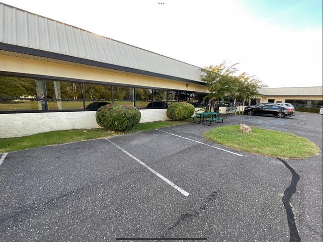
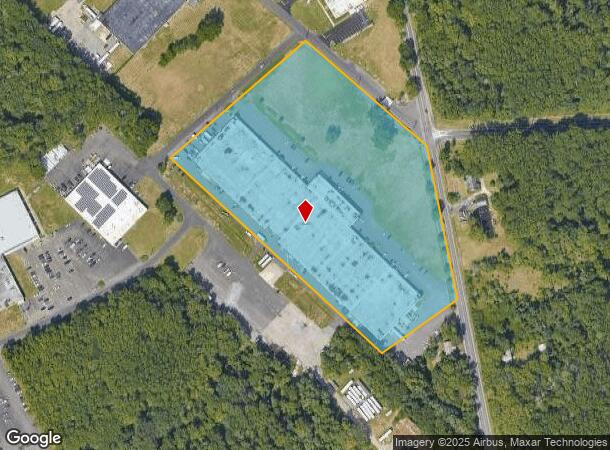
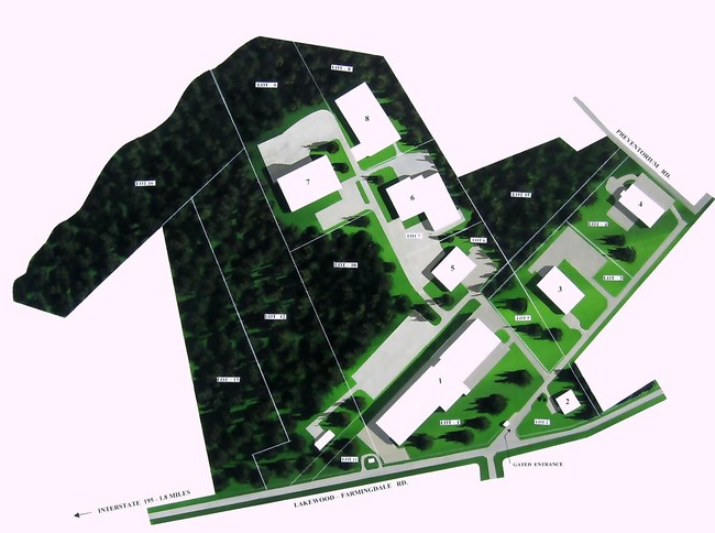
Property Record
100 Central Ave, Farmingdale, NJ 07727

Current Lease Availabilities
NEARBY LISTINGS FOR SALE OR LEASE
Property Detail
100 Central Ave
21-00049-0000-00047-01
Monmouth
Warehouse
New Jersey
X
47.1
34025C0179F
10.11 AC
2024
Western Monmouth
2025
Northern New Jersey
803400
Lakewood-New Brunswick, NJ
DEMOGRAPHICS near 100 Central Ave
1 Mile
3 Mile
5 Mile
2024 Total Population
1,357
10,079
50,419
2029 Population
1,405
10,050
49,997
Pop Growth 2024-2029
+ 3.54%
(0.29%)
(0.84%)
Average Age
40
43
42
2024 Total Households
512
3,695
17,832
HH Growth 2024-2029
+ 3.32%
(0.35%)
(1.03%)
Median Household Inc
$97,453
$114,058
$118,672
Avg Household Size
2.60
2.70
2.70
2024 Avg HH Vehicles
2.00
2.00
2.00
Median Home Value
$385,074
$536,066
$445,159
Median Year Built
1979
1986
1983
Nearby Places
Map Layers
Map Styles
 Street
 Aerial
- Restaurants
- Banks
- Shops
- Fitness
- Groceries
PUBLIC TRANSPORTATION
COMMUTER RAIL
Belmar (North Jersey Coast Line - NJ Transit Commuter Rail (NJ Transit))
DRIVE
WALK
Distance
Belmar (North Jersey Coast Line - NJ Transit Commuter Rail (NJ Transit))
14 min
9.6 mi
AIRPORT
Trenton Mercer
DRIVE
WALK
Distance
Trenton Mercer
58 min
43.0 mi
Newark Liberty International
DRIVE
WALK
Distance
Newark Liberty International
64 min
49.6 mi
Freight Ports
New York Container Terminal
DRIVE
WALK
Distance
New York Container Terminal
58 min
41.8 mi
Nearby Properties
Address
Land Use
TOTAL SIZE
Lot Size
Zoning
Address
Land Use
TOTAL SIZE
Lot Size
Zoning
152,121 SF
22.16 AC
OR10
Address
Land Use
TOTAL SIZE
Lot Size
Zoning
192,708 SF
33.36 AC
OR10
Address
Land Use
TOTAL SIZE
Lot Size
Zoning
13 AC
R-40
Address
Land Use
TOTAL SIZE
Lot Size
Zoning
25,536 SF
21.95 AC
OR10
Address
Land Use
TOTAL SIZE
Lot Size
Zoning
17,586 SF
386.01 AC
POS
Address
Land Use
TOTAL SIZE
Lot Size
Zoning
912 SF
201.36 AC
RRC
Address
Land Use
TOTAL SIZE
Lot Size
Zoning
240,362 SF
61.13 AC
ARE6
Address
Land Use
TOTAL SIZE
Lot Size
Zoning
3,400 SF
262.97 AC
AI
Address
Land Use
TOTAL SIZE
Lot Size
Zoning
332,213 SF
26.55 AC
OR10
Address
Land Use
TOTAL SIZE
Lot Size
Zoning
2,976 SF
336.41 AC
POS
Address
Land Use
TOTAL SIZE
Lot Size
Zoning
13,350 SF
71.10 AC
ARE6
Address
Land Use
TOTAL SIZE
Lot Size
Zoning
161,000 SF
21.60 AC
ARE2
Address
Land Use
TOTAL SIZE
Lot Size
Zoning
142,676 SF
10.47 AC
OR-2
Address
Land Use
TOTAL SIZE
Lot Size
Zoning
3,474 SF
4.12 AC
OR10
Address
Land Use
TOTAL SIZE
Lot Size
Zoning
79,746 SF
9.06 AC
OR10
Address
Land Use
TOTAL SIZE
Lot Size
Zoning
4,060 SF
270.36 AC
CR40
Address
Land Use
TOTAL SIZE
Lot Size
Zoning
55,984 SF
16.11 AC
LI
Address
Land Use
TOTAL SIZE
Lot Size
Zoning
6.04 AC
OP-2
Address
Land Use
TOTAL SIZE
Lot Size
Zoning
7,064 SF
10.62 AC
OR10
Address
Land Use
TOTAL SIZE
Lot Size
Zoning
91,180 SF
27.20 AC
SED
Address
Land Use
TOTAL SIZE
Lot Size
Zoning
86,936 SF
3.42 AC
LI
Address
Land Use
TOTAL SIZE
Lot Size
Zoning
76,850 SF
9.90 AC
OR10
Address
Land Use
TOTAL SIZE
Lot Size
Zoning
42.76 AC
SED
Address
Land Use
TOTAL SIZE
Lot Size
Zoning
33,128 SF
12.68 AC
ARE6
Address
Land Use
TOTAL SIZE
Lot Size
Zoning
8,676 SF
8.19 AC
OP-2
Address
Land Use
TOTAL SIZE
Lot Size
Zoning
212.49 AC
ARE6
Address
Land Use
TOTAL SIZE
Lot Size
Zoning
27,105 SF
9.41 AC
OP-2
Address
Land Use
TOTAL SIZE
Lot Size
Zoning
13.33 AC
SED
Address
Land Use
TOTAL SIZE
Lot Size
Zoning
7.04 AC
SED
The World's #1 Commercial Real Estate Marketplace
Connect with us
© 2026 CoStar Group
The information above has been obtained from sources believed reliable. While we do not doubt its accuracy we have not verified it and make no guarantee, warranty or representation about it. It is your responsibility to independently confirm its accuracy and completeness. Any projections, opinions, assumptions, or estimates used are for example only and do not represent the current or future performance of the property. The value of this transaction to you depends on tax and other factors which should be evaluated by your tax, financial, and legal advisors. You and your advisors should conduct a careful, independent investigation of the property to determine to your satisfaction the suitability of the property for your needs.