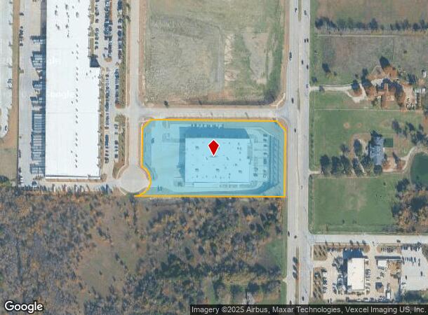
Property Record
15755 Preston Rd, Frisco, TX 75033

NEARBY LISTINGS FOR SALE OR LEASE
Property Detail
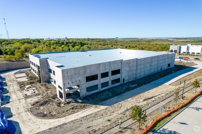
15755 Preston Rd
Dallas-Fort Worth-Arlington, TX
Park 25 (Cfr)
R-11345-00B-0010-1
PARK 25, BLK B, LOT 1
Commercialnec
Collin
X
Texas
48121C0450G
1
2024
5.31 AC
2025
Plano
030519
Dallas/Ft Worth
70,040 SF
DEMOGRAPHICS near 15755 Preston Rd
1 Mile
3 Mile
5 Mile
2024 Total Population
3,475
65,009
218,237
2029 Population
4,408
80,169
268,115
Pop Growth 2024-2029
+ 26.85%
+ 23.32%
+ 22.85%
Average Age
34
34
35
2024 Total Households
1,113
20,389
68,936
HH Growth 2024-2029
+ 27.13%
+ 23.82%
+ 23.23%
Median Household Inc
$179,591
$144,767
$140,928
Avg Household Size
3.10
3.10
3.10
2024 Avg HH Vehicles
2.00
2.00
2.00
Median Home Value
$485,680
$472,327
$473,893
Median Year Built
2011
2010
2010
Nearby Places
Map Layers
Map Styles
 Street
 Aerial
- Restaurants
- Banks
- Shops
- Fitness
- Groceries
PUBLIC TRANSPORTATION
AIRPORT
Dallas Love Field
DRIVE
WALK
Distance
Dallas Love Field
40 min
31.2 mi
Dallas-Fort Worth International
DRIVE
WALK
Distance
Dallas-Fort Worth International
39 min
32.0 mi
Freight Ports
Port of Shreveport
DRIVE
WALK
Distance
Port of Shreveport
243 min
224.5 mi
SALE & LEASE HISTORY
LISTING DATE
SALE/LEASE

Dec 10, 2021
For Lease
Nearby Properties
Address
Land Use
TOTAL SIZE
Lot Size
Zoning
Address
Land Use
TOTAL SIZE
Lot Size
Zoning
479,244 SF
26.82 AC
COMM
Address
Land Use
TOTAL SIZE
Lot Size
Zoning
343,317 SF
17.17 AC
Address
Land Use
TOTAL SIZE
Lot Size
Zoning
882,734 SF
98.26 AC
Address
Land Use
TOTAL SIZE
Lot Size
Zoning
458,757 SF
83.22 AC
Address
Land Use
TOTAL SIZE
Lot Size
Zoning
797,358 SF
41.94 AC
Address
Land Use
TOTAL SIZE
Lot Size
Zoning
491,094 SF
14.06 AC
Address
Land Use
TOTAL SIZE
Lot Size
Zoning
490,246 SF
24.39 AC
MF-M
Address
Land Use
TOTAL SIZE
Lot Size
Zoning
151,733 SF
Address
Land Use
TOTAL SIZE
Lot Size
Zoning
530,080 SF
16.91 AC
Address
Land Use
TOTAL SIZE
Lot Size
Zoning
352,470 SF
96.59 AC
Address
Land Use
TOTAL SIZE
Lot Size
Zoning
533,937 SF
17.44 AC
MF-M
Address
Land Use
TOTAL SIZE
Lot Size
Zoning
386,806 SF
22.59 AC
Address
Land Use
TOTAL SIZE
Lot Size
Zoning
516,677 SF
23.69 AC
Address
Land Use
TOTAL SIZE
Lot Size
Zoning
389,116 SF
9.72 AC
Address
Land Use
TOTAL SIZE
Lot Size
Zoning
218,013 SF
32.85 AC
AG
Address
Land Use
TOTAL SIZE
Lot Size
Zoning
536,616 SF
23.21 AC
MF-M
Address
Land Use
TOTAL SIZE
Lot Size
Zoning
348,136 SF
23.07 AC
MF-L
Address
Land Use
TOTAL SIZE
Lot Size
Zoning
360,589 SF
22.99 AC
MU
Address
Land Use
TOTAL SIZE
Lot Size
Zoning
339,685 SF
13.82 AC
MF
Address
Land Use
TOTAL SIZE
Lot Size
Zoning
352,475 SF
16.80 AC
MF-M
Address
Land Use
TOTAL SIZE
Lot Size
Zoning
365,199 SF
6.79 AC
Address
Land Use
TOTAL SIZE
Lot Size
Zoning
275,288 SF
19.40 AC
MF-M
Address
Land Use
TOTAL SIZE
Lot Size
Zoning
262,995 SF
10.27 AC
Address
Land Use
TOTAL SIZE
Lot Size
Zoning
309,073 SF
32.96 AC
Address
Land Use
TOTAL SIZE
Lot Size
Zoning
146,061 SF
49.28 AC
NS
Address
Land Use
TOTAL SIZE
Lot Size
Zoning
251,455 SF
35.62 AC
Address
Land Use
TOTAL SIZE
Lot Size
Zoning
144,634 SF
27.65 AC
Address
Land Use
TOTAL SIZE
Lot Size
Zoning
436,200 SF
24.95 AC
Address
Land Use
TOTAL SIZE
Lot Size
Zoning
208,462 SF
24.46 AC
Address
Land Use
TOTAL SIZE
Lot Size
Zoning
429,823 SF
73.82 AC
The World's #1 Commercial Real Estate Marketplace
Connect with us
© 2026 CoStar Group
The information above has been obtained from sources believed reliable. While we do not doubt its accuracy we have not verified it and make no guarantee, warranty or representation about it. It is your responsibility to independently confirm its accuracy and completeness. Any projections, opinions, assumptions, or estimates used are for example only and do not represent the current or future performance of the property. The value of this transaction to you depends on tax and other factors which should be evaluated by your tax, financial, and legal advisors. You and your advisors should conduct a careful, independent investigation of the property to determine to your satisfaction the suitability of the property for your needs.