Property Record
100 Charlton Rd, Sturbridge, MA 01566
NEARBY LISTINGS FOR SALE OR LEASE
-
-
View all Sturbridge listings for lease on LoopNet.com
Property Detail
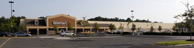
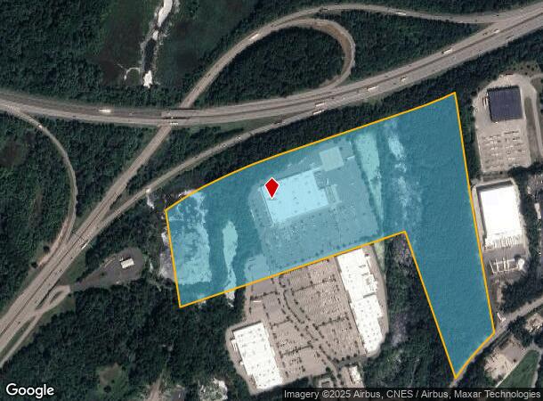
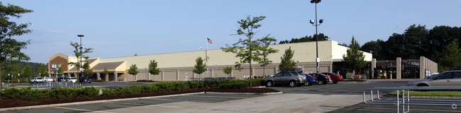
100 Charlton Rd
STUR-000208-000000-002234-000100
Worcester
Regionalshoppingcenterormallwithanchorstore
Massachusetts
A
2234
25027C0768F
40.84 AC
2025
Outlying Worcester
2025
Boston
758104
Worcester, MA-CT
93,552 SF
DEMOGRAPHICS near 100 Charlton Rd
1 Mile
3 Mile
5 Mile
2024 Total Population
689
8,734
33,759
2029 Population
691
8,741
33,558
Pop Growth 2024-2029
+ 0.29%
+ 0.08%
(0.60%)
Average Age
42
42
42
2024 Total Households
260
3,457
13,629
HH Growth 2024-2029
0.00%
+ 0.03%
(0.62%)
Median Household Inc
$115,064
$102,567
$76,155
Avg Household Size
2.60
2.50
2.40
2024 Avg HH Vehicles
2.00
2.00
2.00
Median Home Value
$422,580
$375,908
$342,314
Median Year Built
1980
1978
1969
Nearby Places
Map Layers
Map Styles
 Street
 Aerial
- Restaurants
- Banks
- Shops
- Fitness
- Groceries
PUBLIC TRANSPORTATION
AIRPORT
Worcester Regional
DRIVE
WALK
Distance
Worcester Regional
36 min
18.1 mi
Freight Ports
Port of Davisville, RI
DRIVE
WALK
Distance
Port of Davisville, RI
96 min
73.5 mi
SALE & LEASE HISTORY
LISTING DATE
SALE/LEASE

Jun 23, 2017
For Lease
Feb 01, 2018
For Lease
Nearby Properties
Address
Land Use
TOTAL SIZE
Lot Size
Zoning
Address
Land Use
TOTAL SIZE
Lot Size
Zoning
1,800 SF
10.02 AC
IG
Address
Land Use
TOTAL SIZE
Lot Size
Zoning
15,648 SF
50.82 AC
A
Address
Land Use
TOTAL SIZE
Lot Size
Zoning
127,762 SF
19.28 AC
Address
Land Use
TOTAL SIZE
Lot Size
Zoning
45.13 AC
GB
Address
Land Use
TOTAL SIZE
Lot Size
Zoning
102,966 SF
30.95 AC
Address
Land Use
TOTAL SIZE
Lot Size
Zoning
189,270 SF
97.55 AC
FB
Address
Land Use
TOTAL SIZE
Lot Size
Zoning
Address
Land Use
TOTAL SIZE
Lot Size
Zoning
208,444 SF
14.09 AC
Address
Land Use
TOTAL SIZE
Lot Size
Zoning
Address
Land Use
TOTAL SIZE
Lot Size
Zoning
195.60 AC
IG
Address
Land Use
TOTAL SIZE
Lot Size
Zoning
105,660 SF
Address
Land Use
TOTAL SIZE
Lot Size
Zoning
15,000 SF
2 AC
Address
Land Use
TOTAL SIZE
Lot Size
Zoning
5,024 SF
10.60 AC
Address
Land Use
TOTAL SIZE
Lot Size
Zoning
43,817 SF
3.17 AC
Address
Land Use
TOTAL SIZE
Lot Size
Zoning
55,530 SF
4.74 AC
Address
Land Use
TOTAL SIZE
Lot Size
Zoning
45.59 AC
IG
Address
Land Use
TOTAL SIZE
Lot Size
Zoning
76,734 SF
7.75 AC
IG
Address
Land Use
TOTAL SIZE
Lot Size
Zoning
226.35 AC
M
Address
Land Use
TOTAL SIZE
Lot Size
Zoning
52,255 SF
Address
Land Use
TOTAL SIZE
Lot Size
Zoning
36,220 SF
1.42 AC
Address
Land Use
TOTAL SIZE
Lot Size
Zoning
65,104 SF
9.60 AC
Address
Land Use
TOTAL SIZE
Lot Size
Zoning
2,267 SF
10 AC
A
Address
Land Use
TOTAL SIZE
Lot Size
Zoning
22.15 AC
R40
Address
Land Use
TOTAL SIZE
Lot Size
Zoning
1,237.46 AC
Address
Land Use
TOTAL SIZE
Lot Size
Zoning
4,888 SF
12.33 AC
Address
Land Use
TOTAL SIZE
Lot Size
Zoning
51,006 SF
10.54 AC
Address
Land Use
TOTAL SIZE
Lot Size
Zoning
53,267 SF
4.16 AC
Address
Land Use
TOTAL SIZE
Lot Size
Zoning
73,136 SF
7.70 AC
Address
Land Use
TOTAL SIZE
Lot Size
Zoning
35,281 SF
2.68 AC
The World's #1 Commercial Real Estate Marketplace
Connect with us
© 2025 CoStar Group
The information above has been obtained from sources believed reliable. While we do not doubt its accuracy we have not verified it and make no guarantee, warranty or representation about it. It is your responsibility to independently confirm its accuracy and completeness. Any projections, opinions, assumptions, or estimates used are for example only and do not represent the current or future performance of the property. The value of this transaction to you depends on tax and other factors which should be evaluated by your tax, financial, and legal advisors. You and your advisors should conduct a careful, independent investigation of the property to determine to your satisfaction the suitability of the property for your needs.