Property Record
100 Deer St, Milford, MA 01757


NEARBY LISTINGS FOR SALE OR LEASE
-
-
View all Milford listings for sale on LoopNet.com
Property Detail
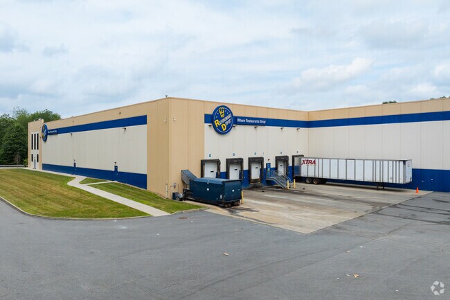
100 Deer St
MILF-000015-000000-000004C
Worcester
Storebuilding
Massachusetts
X
4c
25027C0867F
6.59 AC
2025
Outlying Worcester
2025
Boston
744103
Worcester, MA-CT
63,188 SF
DEMOGRAPHICS near 100 Deer St
1 Mile
3 Mile
5 Mile
2024 Total Population
2,831
37,657
77,182
2029 Population
2,894
37,315
76,817
Pop Growth 2024-2029
+ 2.23%
(0.91%)
(0.47%)
Average Age
43
41
41
2024 Total Households
1,181
14,038
28,145
HH Growth 2024-2029
+ 2.12%
(0.99%)
(0.53%)
Median Household Inc
$108,282
$104,526
$125,523
Avg Household Size
2.40
2.60
2.70
2024 Avg HH Vehicles
2.00
2.00
2.00
Median Home Value
$407,171
$430,894
$494,234
Median Year Built
1988
1972
1975
Nearby Places
Map Layers
Map Styles
 Street
 Aerial
- Restaurants
- Banks
- Shops
- Fitness
- Groceries
PUBLIC TRANSPORTATION
COMMUTER RAIL
Southborough (Framingham/Worcester Line - Massachusetts Bay Transportation Authority Commuter Rail (Purple Line))
DRIVE
WALK
Distance
Southborough (Framingham/Worcester Line - Massachusetts Bay Transportation Authority Commuter Rail (Purple Line))
15 min
8.7 mi
AIRPORT
Worcester Regional
DRIVE
WALK
Distance
Worcester Regional
44 min
27.3 mi
General Edward Lawrence Logan International
DRIVE
WALK
Distance
General Edward Lawrence Logan International
55 min
40.2 mi
Freight Ports
Port of Boston
DRIVE
WALK
Distance
Port of Boston
53 min
38.6 mi
Nearby Properties
Address
Land Use
TOTAL SIZE
Lot Size
Zoning
Address
Land Use
TOTAL SIZE
Lot Size
Zoning
97.74 AC
IA
Address
Land Use
TOTAL SIZE
Lot Size
Zoning
16.82 AC
BP
Address
Land Use
TOTAL SIZE
Lot Size
Zoning
204,879 SF
12.44 AC
OR
Address
Land Use
TOTAL SIZE
Lot Size
Zoning
381,306 SF
20 AC
RB
Address
Land Use
TOTAL SIZE
Lot Size
Zoning
186,720 SF
13.77 AC
RB
Address
Land Use
TOTAL SIZE
Lot Size
Zoning
24.81 AC
IB
Address
Land Use
TOTAL SIZE
Lot Size
Zoning
49.73 AC
IA
Address
Land Use
TOTAL SIZE
Lot Size
Zoning
29.43 AC
IA
Address
Land Use
TOTAL SIZE
Lot Size
Zoning
27.32 AC
IB
Address
Land Use
TOTAL SIZE
Lot Size
Zoning
67.20 AC
RB
Address
Land Use
TOTAL SIZE
Lot Size
Zoning
347,012 SF
29.23 AC
IB
Address
Land Use
TOTAL SIZE
Lot Size
Zoning
139,403 SF
21.44 AC
RB
Address
Land Use
TOTAL SIZE
Lot Size
Zoning
16.50 AC
RA
Address
Land Use
TOTAL SIZE
Lot Size
Zoning
7.36 AC
RA
Address
Land Use
TOTAL SIZE
Lot Size
Zoning
94,399 SF
28.70 AC
RB1
Address
Land Use
TOTAL SIZE
Lot Size
Zoning
21.69 AC
IB
Address
Land Use
TOTAL SIZE
Lot Size
Zoning
14 AC
IB
Address
Land Use
TOTAL SIZE
Lot Size
Zoning
85,200 SF
35.18 AC
IB
Address
Land Use
TOTAL SIZE
Lot Size
Zoning
135,579 SF
15.97 AC
IB
Address
Land Use
TOTAL SIZE
Lot Size
Zoning
11 AC
IB
Address
Land Use
TOTAL SIZE
Lot Size
Zoning
27.79 AC
IB
Address
Land Use
TOTAL SIZE
Lot Size
Zoning
4.17 AC
RB
Address
Land Use
TOTAL SIZE
Lot Size
Zoning
14.75 AC
IB
Address
Land Use
TOTAL SIZE
Lot Size
Zoning
7.80 AC
IB
Address
Land Use
TOTAL SIZE
Lot Size
Zoning
61,100 SF
15.24 AC
I
Address
Land Use
TOTAL SIZE
Lot Size
Zoning
14.83 AC
CC
Address
Land Use
TOTAL SIZE
Lot Size
Zoning
142,594 SF
13.74 AC
IB
Address
Land Use
TOTAL SIZE
Lot Size
Zoning
69,139 SF
4.57 AC
CB
Address
Land Use
TOTAL SIZE
Lot Size
Zoning
63,600 SF
4.93 AC
IA
Address
Land Use
TOTAL SIZE
Lot Size
Zoning
167,299 SF
9.07 AC
IB
The World's #1 Commercial Real Estate Marketplace
Connect with us
© 2025 CoStar Group
The information above has been obtained from sources believed reliable. While we do not doubt its accuracy we have not verified it and make no guarantee, warranty or representation about it. It is your responsibility to independently confirm its accuracy and completeness. Any projections, opinions, assumptions, or estimates used are for example only and do not represent the current or future performance of the property. The value of this transaction to you depends on tax and other factors which should be evaluated by your tax, financial, and legal advisors. You and your advisors should conduct a careful, independent investigation of the property to determine to your satisfaction the suitability of the property for your needs.