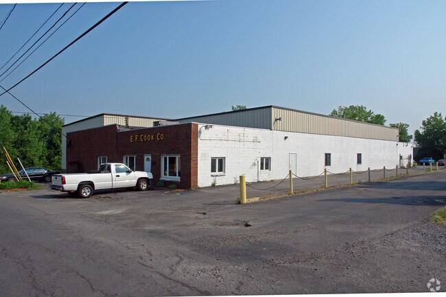
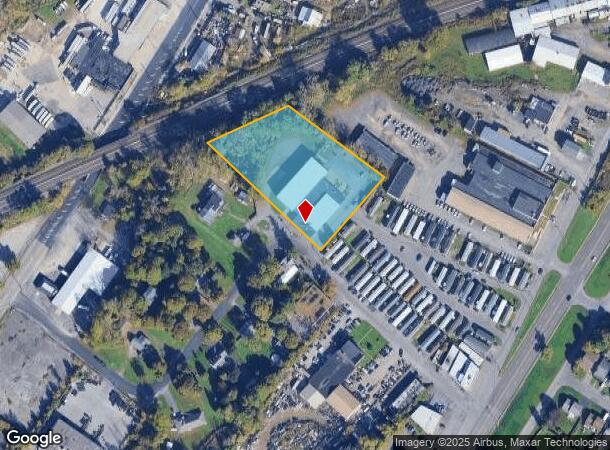
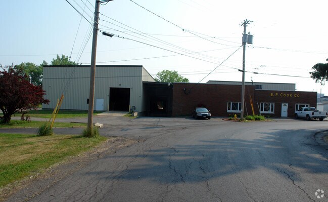
Property Record
100 Dippold Ave, Syracuse, NY 13208
NEARBY LISTINGS FOR SALE OR LEASE
Property Detail
100 Dippold Ave
314889-073-000-0005-008-001-0000
FL 27
Manufacturinglight
Onondaga
X
New York
36067C0209F
8.001
2025
2.32 AC
2024
SE Outer Onondaga County
014200
Syracuse
21,660 SF
Syracuse, NY
DEMOGRAPHICS near 100 Dippold Ave
1 Mile
3 Mile
5 Mile
2024 Total Population
12,154
91,665
224,882
2029 Population
11,845
89,357
219,814
Pop Growth 2024-2029
(2.54%)
(2.52%)
(2.25%)
Average Age
40
39
38
2024 Total Households
5,017
41,213
93,934
HH Growth 2024-2029
(2.73%)
(2.45%)
(2.36%)
Median Household Inc
$59,803
$47,869
$52,482
Avg Household Size
2.30
2.10
2.20
2024 Avg HH Vehicles
2.00
1.00
1.00
Median Home Value
$95,057
$126,383
$141,974
Median Year Built
1948
1952
1954
Nearby Places
Map Layers
Map Styles
 Street
 Aerial
- Restaurants
- Banks
- Shops
- Fitness
- Groceries
PUBLIC TRANSPORTATION
COMMUTER RAIL
Syracuse Regional Transportation Center (Empire Service - Amtrak, Lake Shore Limited - Amtrak, Maple Leaf - Amtrak)
DRIVE
WALK
Distance
Syracuse Regional Transportation Center (Empire Service - Amtrak, Lake Shore Limited - Amtrak, Maple Leaf - Amtrak)
5 min
1.7 mi
Syracuse (Toronto - New York - VIA Rail)
DRIVE
WALK
Distance
Syracuse (Toronto - New York - VIA Rail)
5 min
1.7 mi
AIRPORT
Syracuse Hancock International
DRIVE
WALK
Distance
Syracuse Hancock International
9 min
3.9 mi
Freight Ports
Albany, NY Port
DRIVE
WALK
Distance
Albany, NY Port
170 min
143.4 mi
Nearby Properties
Address
Land Use
TOTAL SIZE
Lot Size
Zoning
Address
Land Use
TOTAL SIZE
Lot Size
Zoning
847,042 SF
42.78 AC
23
Address
Land Use
TOTAL SIZE
Lot Size
Zoning
57,011 SF
22.53 AC
22
Address
Land Use
TOTAL SIZE
Lot Size
Zoning
508,658 SF
2.23 AC
25
Address
Land Use
TOTAL SIZE
Lot Size
Zoning
848,000 SF
30.29 AC
Address
Land Use
TOTAL SIZE
Lot Size
Zoning
72,200 SF
12.39 AC
06 - INDUS
Address
Land Use
TOTAL SIZE
Lot Size
Zoning
409,062 SF
10
Address
Land Use
TOTAL SIZE
Lot Size
Zoning
522,469 SF
1.87 AC
14
Address
Land Use
TOTAL SIZE
Lot Size
Zoning
6,598 SF
4.09 AC
14
Address
Land Use
TOTAL SIZE
Lot Size
Zoning
108,368 SF
3.36 AC
14
Address
Land Use
TOTAL SIZE
Lot Size
Zoning
414,700 SF
1.94 AC
07 - MIXED
Address
Land Use
TOTAL SIZE
Lot Size
Zoning
653,177 SF
1.94 AC
13
Address
Land Use
TOTAL SIZE
Lot Size
Zoning
224,736 SF
2.48 AC
10
Address
Land Use
TOTAL SIZE
Lot Size
Zoning
13,800 SF
2.10 AC
16
Address
Land Use
TOTAL SIZE
Lot Size
Zoning
275,732 SF
2.91 AC
13
Address
Land Use
TOTAL SIZE
Lot Size
Zoning
296,703 SF
1.48 AC
25
Address
Land Use
TOTAL SIZE
Lot Size
Zoning
5,837 SF
1.26 AC
15
Address
Land Use
TOTAL SIZE
Lot Size
Zoning
169,752 SF
12.81 AC
04 - FARM
Address
Land Use
TOTAL SIZE
Lot Size
Zoning
432,246 SF
37.21 AC
05 - COMME
Address
Land Use
TOTAL SIZE
Lot Size
Zoning
367,508 SF
0.48 AC
12
Address
Land Use
TOTAL SIZE
Lot Size
Zoning
329,212 SF
2.11 AC
12
Address
Land Use
TOTAL SIZE
Lot Size
Zoning
79,344 SF
1.65 AC
14
Address
Land Use
TOTAL SIZE
Lot Size
Zoning
410,021 SF
2.22 AC
05 - COMME
Address
Land Use
TOTAL SIZE
Lot Size
Zoning
22.16 AC
06 - INDUS
Address
Land Use
TOTAL SIZE
Lot Size
Zoning
11,484 SF
16.36 AC
03 - MULTI
Address
Land Use
TOTAL SIZE
Lot Size
Zoning
115,000 SF
07 - MIXED
Address
Land Use
TOTAL SIZE
Lot Size
Zoning
37,045 SF
5.58 AC
06 - INDUS
Address
Land Use
TOTAL SIZE
Lot Size
Zoning
297,376 SF
1.88 AC
13
Address
Land Use
TOTAL SIZE
Lot Size
Zoning
40,684 SF
1.62 AC
08 - GOVER
Address
Land Use
TOTAL SIZE
Lot Size
Zoning
285,000 SF
10.94 AC
23
The World's #1 Commercial Real Estate Marketplace
Connect with us
© 2026 CoStar Group
The information above has been obtained from sources believed reliable. While we do not doubt its accuracy we have not verified it and make no guarantee, warranty or representation about it. It is your responsibility to independently confirm its accuracy and completeness. Any projections, opinions, assumptions, or estimates used are for example only and do not represent the current or future performance of the property. The value of this transaction to you depends on tax and other factors which should be evaluated by your tax, financial, and legal advisors. You and your advisors should conduct a careful, independent investigation of the property to determine to your satisfaction the suitability of the property for your needs.