Property Record
100 Drybridge Ct, Sandston, VA 23150


NEARBY LISTINGS FOR SALE OR LEASE
-
-
View all Sandston listings for sale on LoopNet.com
Property Detail
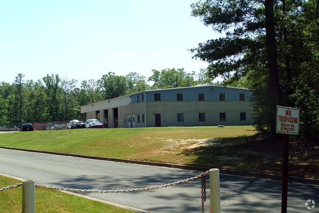
100 Drybridge Ct
836-717-9828
01650A0000 0074NR; MEADOW RD AC 6.605 44 B1 32
Multipleuses
Henrico
X
Virginia
51085C0445C
6.61 AC
2025
Airport
2025
Richmond VA
201403
Richmond, VA
14,160 SF
DEMOGRAPHICS near 100 Drybridge Ct
1 Mile
3 Mile
5 Mile
2024 Total Population
1,453
14,983
39,457
2029 Population
1,441
14,933
39,629
Pop Growth 2024-2029
(0.83%)
(0.33%)
+ 0.44%
Average Age
40
40
41
2024 Total Households
609
6,084
15,929
HH Growth 2024-2029
(0.82%)
(0.36%)
+ 0.40%
Median Household Inc
$64,342
$62,117
$61,980
Avg Household Size
2.40
2.40
2.40
2024 Avg HH Vehicles
2.00
2.00
2.00
Median Home Value
$207,394
$185,930
$199,902
Median Year Built
1970
1975
1979
Nearby Places
Map Layers
Map Styles
 Street
 Aerial
- Restaurants
- Banks
- Shops
- Fitness
- Groceries
PUBLIC TRANSPORTATION
AIRPORT
Richmond International
DRIVE
WALK
Distance
Richmond International
10 min
3.6 mi
Freight Ports
Virginia Port Authority - Richmond
DRIVE
WALK
Distance
Virginia Port Authority - Richmond
25 min
15.1 mi
Nearby Properties
Address
Land Use
TOTAL SIZE
Lot Size
Zoning
Address
Land Use
TOTAL SIZE
Lot Size
Zoning
143,287 SF
56.39 AC
MIXE
Address
Land Use
TOTAL SIZE
Lot Size
Zoning
716,824 SF
60.89 AC
M-2C
Address
Land Use
TOTAL SIZE
Lot Size
Zoning
117,522 SF
67.74 AC
A-1
Address
Land Use
TOTAL SIZE
Lot Size
Zoning
322,000 SF
15.94 AC
M-1
Address
Land Use
TOTAL SIZE
Lot Size
Zoning
181,200 SF
14.74 AC
R-5
Address
Land Use
TOTAL SIZE
Lot Size
Zoning
212,576 SF
94.90 AC
MIXE
Address
Land Use
TOTAL SIZE
Lot Size
Zoning
53,530 SF
4.50 AC
M-1C
Address
Land Use
TOTAL SIZE
Lot Size
Zoning
144,135 SF
9.72 AC
M-1
Address
Land Use
TOTAL SIZE
Lot Size
Zoning
63,700 SF
19.50 AC
A-1
Address
Land Use
TOTAL SIZE
Lot Size
Zoning
130,638 SF
11.06 AC
R-5
Address
Land Use
TOTAL SIZE
Lot Size
Zoning
1,546 SF
43.18 AC
MIXE
Address
Land Use
TOTAL SIZE
Lot Size
Zoning
87,384 SF
8.05 AC
R-5
Address
Land Use
TOTAL SIZE
Lot Size
Zoning
5,918 SF
41.66 AC
M-2
Address
Land Use
TOTAL SIZE
Lot Size
Zoning
80,815 SF
3.25 AC
M-1
Address
Land Use
TOTAL SIZE
Lot Size
Zoning
120,860 SF
15.03 AC
M1-C
Address
Land Use
TOTAL SIZE
Lot Size
Zoning
42,755 SF
103.73 AC
M-1
Address
Land Use
TOTAL SIZE
Lot Size
Zoning
123,668 SF
125.60 AC
A-1
Address
Land Use
TOTAL SIZE
Lot Size
Zoning
88,367 SF
4.01 AC
M-1
Address
Land Use
TOTAL SIZE
Lot Size
Zoning
108,900 SF
7.58 AC
R-5
Address
Land Use
TOTAL SIZE
Lot Size
Zoning
141,588 SF
12.66 AC
M-1
Address
Land Use
TOTAL SIZE
Lot Size
Zoning
50,190 SF
14.43 AC
R-3
Address
Land Use
TOTAL SIZE
Lot Size
Zoning
94,939 SF
4.45 AC
MIXE
Address
Land Use
TOTAL SIZE
Lot Size
Zoning
50,854 SF
38.96 AC
MIXE
Address
Land Use
TOTAL SIZE
Lot Size
Zoning
99,398 SF
6.97 AC
M-1
Address
Land Use
TOTAL SIZE
Lot Size
Zoning
59,975 SF
1.73 AC
M-1
Address
Land Use
TOTAL SIZE
Lot Size
Zoning
78,027 SF
19.82 AC
MIXE
Address
Land Use
TOTAL SIZE
Lot Size
Zoning
Address
Land Use
TOTAL SIZE
Lot Size
Zoning
41,578 SF
7.50 AC
R-4
Address
Land Use
TOTAL SIZE
Lot Size
Zoning
88,832 SF
7.50 AC
R-5
Address
Land Use
TOTAL SIZE
Lot Size
Zoning
28,904 SF
4.69 AC
R-3
The World's #1 Commercial Real Estate Marketplace
Connect with us
© 2026 CoStar Group
The information above has been obtained from sources believed reliable. While we do not doubt its accuracy we have not verified it and make no guarantee, warranty or representation about it. It is your responsibility to independently confirm its accuracy and completeness. Any projections, opinions, assumptions, or estimates used are for example only and do not represent the current or future performance of the property. The value of this transaction to you depends on tax and other factors which should be evaluated by your tax, financial, and legal advisors. You and your advisors should conduct a careful, independent investigation of the property to determine to your satisfaction the suitability of the property for your needs.