Property Record
100 E 9Th St, Cincinnati, OH 45202
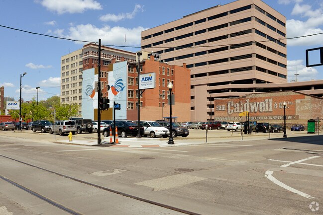
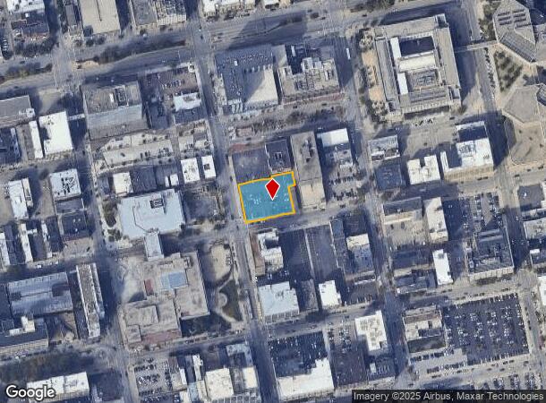
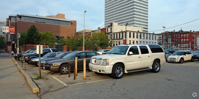
Property Detail
100 E 9Th St
Cincinnati, OH-KY-IN
E NINTH ST 0.530 AC R1 T4 S18
079-0001-0074
HAMILTON
Parkingstructure
Ohio
DD
13
B and X Area of moderate flood hazard, usually the area between the limits of the 100-year and 500-year floods.
0.25 AC
2025
Cincinnati CBD
2025
Cincinnati/Dayton
000700
NEARBY LISTINGS FOR SALE OR LEASE
DEMOGRAPHICS near 100 E 9Th St
1 mile
3 mile
5 mile
2025 Total Population
24,745
161,496
330,281
2030 Population
25,917
167,086
338,813
Pop Growth 2025-2030
+ 4.74%
+ 3.46%
+ 2.58%
Average Age
37
37
37
2025 Total Households
13,450
73,534
145,642
HH Growth 2025-2030
+ 4.93%
+ 3.68%
+ 2.72%
Median Household Inc
$77,422
$56,441
$59,300
Avg Household Size
1.70
2.00
2.10
2025 Avg HH Vehicles
1.00
1.00
1.00
Median Home Value
$453,571
$260,351
$259,104
Median Year Built
1949
1948
1949
Nearby Places
Map Layers
Map Styles
 Street
 Aerial
Transit
 Traffic
 Biking
Places
Listings with unknown addresses are not visible on the map
- Restaurants
- Banks
- Shops
- Fitness
- Groceries
PUBLIC TRANSPORTATION
TRANSIT/SUBWAY
Public Library Station - 9Th & Walnut (Streetcar - OTR - Banks - Southwest Ohio Regional Transit Authority)
Drive
Walk
Distance
Public Library Station - 9Th & Walnut (Streetcar - OTR - Banks - Southwest Ohio Regional Transit Authority)
0 min
0 min
0.0 mi
8Th & Main Station (Streetcar - OTR - Banks - Southwest Ohio Regional Transit Authority)
Drive
Walk
Distance
8Th & Main Station (Streetcar - OTR - Banks - Southwest Ohio Regional Transit Authority)
1 min
2 min
0.1 mi
Jack Casino Station - Main & Court (Streetcar - OTR - Banks - Southwest Ohio Regional Transit Authority)
Drive
Walk
Distance
Jack Casino Station - Main & Court (Streetcar - OTR - Banks - Southwest Ohio Regional Transit Authority)
1 min
2 min
0.1 mi
Aronoff Center Station - 7Th & Walnut (Streetcar - OTR - Banks - Southwest Ohio Regional Transit Authority)
Drive
Walk
Distance
Aronoff Center Station - 7Th & Walnut (Streetcar - OTR - Banks - Southwest Ohio Regional Transit Authority)
0 min
4 min
0.2 mi
Central Parkway & Vine Station (Streetcar - OTR - Banks - Southwest Ohio Regional Transit Authority)
Drive
Walk
Distance
Central Parkway & Vine Station (Streetcar - OTR - Banks - Southwest Ohio Regional Transit Authority)
2 min
4 min
0.2 mi
COMMUTER RAIL
Cincinnati Union Terminal (Cardinal - Amtrak)
Drive
Walk
Distance
Cincinnati Union Terminal (Cardinal - Amtrak)
5 min
1.7 mi
AIRPORT
Cincinnati/Northern Kentucky International
Drive
Walk
Distance
Cincinnati/Northern Kentucky International
27 min
14.5 mi
Freight Ports
Port of Toledo
Drive
Walk
Distance
Port of Toledo
242 min
206.5 mi
Nearby Properties
Address
Land Use
TOTAL SIZE
Lot Size
Zoning
Address
Land Use
TOTAL SIZE
Lot Size
Zoning
77.73 AC
IR
Address
Land Use
TOTAL SIZE
Lot Size
Zoning
6.35 AC
IR
Address
Land Use
TOTAL SIZE
Lot Size
Zoning
39.99 AC
MG
Address
Land Use
TOTAL SIZE
Lot Size
Zoning
11.82 AC
Address
Land Use
TOTAL SIZE
Lot Size
Zoning
11.62 AC
Address
Land Use
TOTAL SIZE
Lot Size
Zoning
19.36 AC
Address
Land Use
TOTAL SIZE
Lot Size
Zoning
17.10 AC
DD
Address
Land Use
TOTAL SIZE
Lot Size
Zoning
1.97 AC
DD
Address
Land Use
TOTAL SIZE
Lot Size
Zoning
11.41 AC
IR
Address
Land Use
TOTAL SIZE
Lot Size
Zoning
22.45 AC
Address
Land Use
TOTAL SIZE
Lot Size
Zoning
13.80 AC
Address
Land Use
TOTAL SIZE
Lot Size
Zoning
60,750 SF
1.52 AC
Address
Land Use
TOTAL SIZE
Lot Size
Zoning
2.60 AC
Address
Land Use
TOTAL SIZE
Lot Size
Zoning
9.55 AC
Address
Land Use
TOTAL SIZE
Lot Size
Zoning
3.09 AC
Address
Land Use
TOTAL SIZE
Lot Size
Zoning
2.80 AC
IR
Address
Land Use
TOTAL SIZE
Lot Size
Zoning
3.40 AC
IR
Address
Land Use
TOTAL SIZE
Lot Size
Zoning
89,500 SF
0.58 AC
Address
Land Use
TOTAL SIZE
Lot Size
Zoning
Address
Land Use
TOTAL SIZE
Lot Size
Zoning
290,233 SF
Address
Land Use
TOTAL SIZE
Lot Size
Zoning
3.51 AC
DD
Address
Land Use
TOTAL SIZE
Lot Size
Zoning
9,962 SF
712 AC
Address
Land Use
TOTAL SIZE
Lot Size
Zoning
Address
Land Use
TOTAL SIZE
Lot Size
Zoning
153,312 SF
4 AC
Address
Land Use
TOTAL SIZE
Lot Size
Zoning
9.14 AC
Address
Land Use
TOTAL SIZE
Lot Size
Zoning
11.68 AC
Address
Land Use
TOTAL SIZE
Lot Size
Zoning
21.55 AC
Address
Land Use
TOTAL SIZE
Lot Size
Zoning
298,611 SF
Address
Land Use
TOTAL SIZE
Lot Size
Zoning
20.02 AC
Address
Land Use
TOTAL SIZE
Lot Size
Zoning
2.46 AC
The World's #1 Commercial Real Estate Marketplace
Connect with us
© 2026 CoStar Group
The information above has been obtained from sources believed reliable. While we do not doubt its accuracy we have not verified it and make no guarantee, warranty or representation about it. It is your responsibility to independently confirm its accuracy and completeness. Any projections, opinions, assumptions, or estimates used are for example only and do not represent the current or future performance of the property. The value of this transaction to you depends on tax and other factors which should be evaluated by your tax, financial, and legal advisors. You and your advisors should conduct a careful, independent investigation of the property to determine to your satisfaction the suitability of the property for your needs.