Property Record
100 E Main St, Collinsville, IL 62234


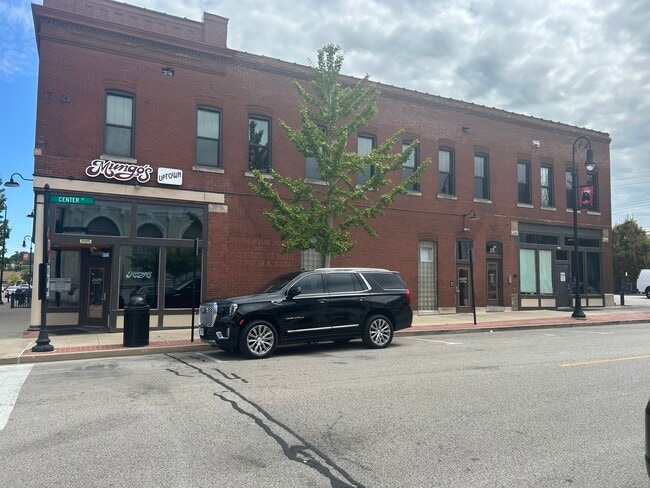
Property Detail
100 E Main St
St. Louis, MO-IL
COLLINSVILLE LOT 1 66X148.5
13-2-21-33-08-204-018
Madison
Storebuilding
Illinois
2025
1
2025
0.23 AC
403300
Metro East Illinois
10,824 SF
St. Louis
NEARBY LISTINGS FOR SALE OR LEASE
DEMOGRAPHICS near 100 E Main St
1 mile
3 mile
5 mile
2025 Total Population
8,753
29,200
56,736
2030 Population
8,697
28,858
56,049
Pop Growth 2025-2030
(0.64%)
(1.17%)
(1.21%)
Average Age
39
41
41
2025 Total Households
3,779
12,578
22,785
HH Growth 2025-2030
(0.69%)
(1.21%)
(1.27%)
Median Household Inc
$65,550
$70,608
$81,476
Avg Household Size
2.30
2.30
2.40
2025 Avg HH Vehicles
2.00
2.00
2.00
Median Home Value
$146,793
$174,739
$205,741
Median Year Built
1961
1969
1977
Nearby Places
Map Layers
Map Styles
 Street
 Aerial
Layers
 Traffic
 Biking
Places
Listings with unknown addresses are not visible on the map
- Restaurants
- Banks
- Shops
- Fitness
- Groceries
PUBLIC TRANSPORTATION
COMMUTER RAIL
Fairview Heights (Lambert Airport Shiloh-Scott - St. Louis MetroLink (MetroLink), Shrewsbury-Lansdowne I-44 Emerson Park - St. Louis MetroLink (MetroLink))
Drive
Walk
Distance
Fairview Heights (Lambert Airport Shiloh-Scott - St. Louis MetroLink (MetroLink), Shrewsbury-Lansdowne I-44 Emerson Park - St. Louis MetroLink (MetroLink))
15 min
7.5 mi
Washington Park (Lambert Airport Shiloh-Scott - St. Louis MetroLink (MetroLink), Shrewsbury-Lansdowne I-44 Emerson Park - St. Louis MetroLink (MetroLink))
Drive
Walk
Distance
Washington Park (Lambert Airport Shiloh-Scott - St. Louis MetroLink (MetroLink), Shrewsbury-Lansdowne I-44 Emerson Park - St. Louis MetroLink (MetroLink))
17 min
9.5 mi
AIRPORT
Scott AFB/Midamerica St Louis
Drive
Walk
Distance
Scott AFB/Midamerica St Louis
30 min
18.1 mi
St Louis Lambert International
Drive
Walk
Distance
St Louis Lambert International
41 min
27.2 mi
Freight Ports
Port Milwaukee
Drive
Walk
Distance
Port Milwaukee
403 min
357.5 mi
Nearby Properties
Address
Land Use
TOTAL SIZE
Lot Size
Zoning
Address
Land Use
TOTAL SIZE
Lot Size
Zoning
148,997 SF
10 AC
Address
Land Use
TOTAL SIZE
Lot Size
Zoning
216,370 SF
23.25 AC
Address
Land Use
TOTAL SIZE
Lot Size
Zoning
131,296 SF
14.21 AC
Address
Land Use
TOTAL SIZE
Lot Size
Zoning
75,400 SF
9.93 AC
Address
Land Use
TOTAL SIZE
Lot Size
Zoning
48,640 SF
3.84 AC
Address
Land Use
TOTAL SIZE
Lot Size
Zoning
Address
Land Use
TOTAL SIZE
Lot Size
Zoning
25,743 SF
3.49 AC
Address
Land Use
TOTAL SIZE
Lot Size
Zoning
54,699 SF
2.20 AC
Address
Land Use
TOTAL SIZE
Lot Size
Zoning
57,825 SF
2.68 AC
Address
Land Use
TOTAL SIZE
Lot Size
Zoning
32,331 SF
14.98 AC
Address
Land Use
TOTAL SIZE
Lot Size
Zoning
57,342 SF
Address
Land Use
TOTAL SIZE
Lot Size
Zoning
8,176 SF
61.11 AC
Address
Land Use
TOTAL SIZE
Lot Size
Zoning
3,868 SF
0.22 AC
Address
Land Use
TOTAL SIZE
Lot Size
Zoning
40,168 SF
1.08 AC
Address
Land Use
TOTAL SIZE
Lot Size
Zoning
40,430 SF
Address
Land Use
TOTAL SIZE
Lot Size
Zoning
84,816 SF
0.89 AC
Address
Land Use
TOTAL SIZE
Lot Size
Zoning
Address
Land Use
TOTAL SIZE
Lot Size
Zoning
756 SF
8.77 AC
Address
Land Use
TOTAL SIZE
Lot Size
Zoning
35,940 SF
1.50 AC
Address
Land Use
TOTAL SIZE
Lot Size
Zoning
50,400 SF
6.67 AC
Address
Land Use
TOTAL SIZE
Lot Size
Zoning
46,660 SF
3.50 AC
Address
Land Use
TOTAL SIZE
Lot Size
Zoning
64,411 SF
1.80 AC
Address
Land Use
TOTAL SIZE
Lot Size
Zoning
5,475 SF
2.91 AC
Address
Land Use
TOTAL SIZE
Lot Size
Zoning
40,176 SF
7.44 AC
Address
Land Use
TOTAL SIZE
Lot Size
Zoning
39,750 SF
3.90 AC
Address
Land Use
TOTAL SIZE
Lot Size
Zoning
31,041 SF
1.62 AC
Address
Land Use
TOTAL SIZE
Lot Size
Zoning
9,904 SF
5.50 AC
Address
Land Use
TOTAL SIZE
Lot Size
Zoning
31,240 SF
5.63 AC
Address
Land Use
TOTAL SIZE
Lot Size
Zoning
35,900 SF
3.28 AC
Address
Land Use
TOTAL SIZE
Lot Size
Zoning
40,994 SF
4 AC
The World's #1 Commercial Real Estate Marketplace
Connect with us
© 2026 CoStar Group
The information above has been obtained from sources believed reliable. While we do not doubt its accuracy we have not verified it and make no guarantee, warranty or representation about it. It is your responsibility to independently confirm its accuracy and completeness. Any projections, opinions, assumptions, or estimates used are for example only and do not represent the current or future performance of the property. The value of this transaction to you depends on tax and other factors which should be evaluated by your tax, financial, and legal advisors. You and your advisors should conduct a careful, independent investigation of the property to determine to your satisfaction the suitability of the property for your needs.