Property Record
100 E Main St, Wales, WI 53183


NEARBY LISTINGS FOR SALE OR LEASE
-
-
View all Wales listings for sale on LoopNet.com
Property Detail
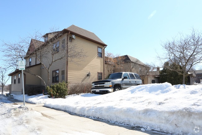
100 E Main St
Milwaukee-Waukesha, WI
Map Of Wales Station
WLSV-1455-056
LOT 1 BLK B MAP OF WALES STATION PT SE1/4 SW1/4 SEC 4 T6N R18E
Residentialnec
Waukesha
X
Wisconsin
55133C0169G
1
2024
0.20 AC
2024
Central Waukesha
203805
Milwaukee/Madison
DEMOGRAPHICS near 100 E Main St
1 mile
3 mile
5 mile
2024 Total Population
5,699
23,009
84,614
2029 Population
5,847
23,364
86,505
Pop Growth 2024-2029
+ 2.60%
+ 1.54%
+ 2.23%
Average Age
44
44
42
2024 Total Households
2,633
10,249
34,813
HH Growth 2024-2029
+ 2.73%
+ 1.51%
+ 2.28%
Median Household Inc
$77,450
$88,581
$90,582
Avg Household Size
2.10
2.20
2.40
2024 Avg HH Vehicles
2.00
2.00
2.00
Median Home Value
$292,955
$350,748
$341,474
Median Year Built
1974
1990
1985
Nearby Places
Map Layers
Map Styles
 Street
 Aerial
Transit
 Traffic
 Biking
Places
Listings with unknown addresses are not visible on the map
- Restaurants
- Banks
- Shops
- Fitness
- Groceries
PUBLIC TRANSPORTATION
AIRPORT
General Mitchell International
Drive
Walk
Distance
General Mitchell International
47 min
33.4 mi
Freight Ports
Port Milwaukee
Drive
Walk
Distance
Port Milwaukee
40 min
30.0 mi
Nearby Properties
Address
Land Use
TOTAL SIZE
Lot Size
Zoning
Address
Land Use
TOTAL SIZE
Lot Size
Zoning
6.33 AC
Address
Land Use
TOTAL SIZE
Lot Size
Zoning
3.33 AC
Address
Land Use
TOTAL SIZE
Lot Size
Zoning
7.66 AC
Address
Land Use
TOTAL SIZE
Lot Size
Zoning
59.06 AC
Address
Land Use
TOTAL SIZE
Lot Size
Zoning
12.98 AC
Address
Land Use
TOTAL SIZE
Lot Size
Zoning
183.31 AC
Address
Land Use
TOTAL SIZE
Lot Size
Zoning
1.87 AC
Address
Land Use
TOTAL SIZE
Lot Size
Zoning
3.94 AC
Address
Land Use
TOTAL SIZE
Lot Size
Zoning
Address
Land Use
TOTAL SIZE
Lot Size
Zoning
2.18 AC
Address
Land Use
TOTAL SIZE
Lot Size
Zoning
1.39 AC
Address
Land Use
TOTAL SIZE
Lot Size
Zoning
Address
Land Use
TOTAL SIZE
Lot Size
Zoning
21.70 AC
Address
Land Use
TOTAL SIZE
Lot Size
Zoning
4.77 AC
Address
Land Use
TOTAL SIZE
Lot Size
Zoning
2.01 AC
Address
Land Use
TOTAL SIZE
Lot Size
Zoning
1.08 AC
Address
Land Use
TOTAL SIZE
Lot Size
Zoning
1.20 AC
Address
Land Use
TOTAL SIZE
Lot Size
Zoning
Address
Land Use
TOTAL SIZE
Lot Size
Zoning
75.05 AC
Address
Land Use
TOTAL SIZE
Lot Size
Zoning
Address
Land Use
TOTAL SIZE
Lot Size
Zoning
Address
Land Use
TOTAL SIZE
Lot Size
Zoning
6.33 AC
Address
Land Use
TOTAL SIZE
Lot Size
Zoning
1.35 AC
Address
Land Use
TOTAL SIZE
Lot Size
Zoning
6.82 AC
Address
Land Use
TOTAL SIZE
Lot Size
Zoning
82.42 AC
Address
Land Use
TOTAL SIZE
Lot Size
Zoning
Address
Land Use
TOTAL SIZE
Lot Size
Zoning
Address
Land Use
TOTAL SIZE
Lot Size
Zoning
Address
Land Use
TOTAL SIZE
Lot Size
Zoning
1.14 AC
Address
Land Use
TOTAL SIZE
Lot Size
Zoning
1.28 AC
The World's #1 Commercial Real Estate Marketplace
Connect with us
© 2026 CoStar Group
The information above has been obtained from sources believed reliable. While we do not doubt its accuracy we have not verified it and make no guarantee, warranty or representation about it. It is your responsibility to independently confirm its accuracy and completeness. Any projections, opinions, assumptions, or estimates used are for example only and do not represent the current or future performance of the property. The value of this transaction to you depends on tax and other factors which should be evaluated by your tax, financial, and legal advisors. You and your advisors should conduct a careful, independent investigation of the property to determine to your satisfaction the suitability of the property for your needs.