Property Record
100 E Mary St, Lansing, KS 66043

Save to a Folder
{{folder.Name}}
{{folder.ListingIds.length}} Properties
{{folder.ListingIds.length}} Property
Create a New Folder
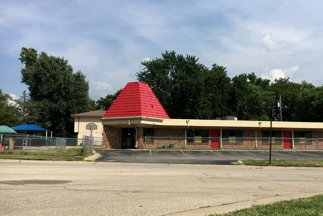
Property Detail
100 E Mary St
Kansas City, MO-KS
MCCLURG-THORNE SUB, S30, T09, R23E, LOT 1 - 2
099-30-0-20-02-008.00-0
Leavenworth
Daycare
Kansas
B and X Area of moderate flood hazard, usually the area between the limits of the 100-year and 500-year floods.
1
2024
0.55 AC
2025
Leavenworth County
071102
Kansas City
4,696 SF
NEARBY LISTINGS FOR SALE OR LEASE
DEMOGRAPHICS near 100 E Mary St
1 mile
3 mile
5 mile
2025 Total Population
6,154
16,885
35,592
2030 Population
6,294
17,320
36,629
Pop Growth 2025-2030
+ 2.27%
+ 2.58%
+ 2.91%
Average Age
40
40
41
2025 Total Households
1,811
5,275
12,737
HH Growth 2025-2030
+ 2.37%
+ 2.79%
+ 3.16%
Median Household Inc
$95,229
$92,415
$80,530
Avg Household Size
2.70
2.60
2.50
2025 Avg HH Vehicles
2.00
2.00
2.00
Median Home Value
$279,999
$286,169
$252,875
Median Year Built
1984
1984
1981
Nearby Places
Map Layers
Map Styles
 Street
 Aerial
Layers
 Traffic
 Biking
Places
Listings with unknown addresses are not visible on the map
- Restaurants
- Banks
- Shops
- Fitness
- Groceries
PUBLIC TRANSPORTATION
AIRPORT
Kansas City International
Drive
Walk
Distance
Kansas City International
40 min
26.7 mi
Freight Ports
Tulsa Port Of Catoosa
Drive
Walk
Distance
Tulsa Port Of Catoosa
285 min
253.2 mi
SALE & LEASE HISTORY
LISTING DATE
SALE/LEASE

Jun 14, 2019
For Lease
Nearby Properties
Address
Land Use
TOTAL SIZE
Lot Size
Zoning
Address
Land Use
TOTAL SIZE
Lot Size
Zoning
2,949 SF
398.40 AC
Address
Land Use
TOTAL SIZE
Lot Size
Zoning
546,636 SF
143.55 AC
Address
Land Use
TOTAL SIZE
Lot Size
Zoning
238,164 SF
153.40 AC
Address
Land Use
TOTAL SIZE
Lot Size
Zoning
141,398 SF
24.20 AC
Address
Land Use
TOTAL SIZE
Lot Size
Zoning
247,316 SF
192.75 AC
Address
Land Use
TOTAL SIZE
Lot Size
Zoning
200,862 SF
39.51 AC
Address
Land Use
TOTAL SIZE
Lot Size
Zoning
89,647 SF
24.76 AC
Address
Land Use
TOTAL SIZE
Lot Size
Zoning
48,527 SF
19.79 AC
Address
Land Use
TOTAL SIZE
Lot Size
Zoning
32,463 SF
7.60 AC
Address
Land Use
TOTAL SIZE
Lot Size
Zoning
7,720 SF
133.73 AC
Address
Land Use
TOTAL SIZE
Lot Size
Zoning
203,193 SF
33.15 AC
Address
Land Use
TOTAL SIZE
Lot Size
Zoning
346.96 AC
Address
Land Use
TOTAL SIZE
Lot Size
Zoning
42,056 SF
4.35 AC
Address
Land Use
TOTAL SIZE
Lot Size
Zoning
117,680 SF
8.49 AC
Address
Land Use
TOTAL SIZE
Lot Size
Zoning
25,661 SF
3.47 AC
Address
Land Use
TOTAL SIZE
Lot Size
Zoning
70.64 AC
Address
Land Use
TOTAL SIZE
Lot Size
Zoning
55,961 SF
22.45 AC
Address
Land Use
TOTAL SIZE
Lot Size
Zoning
118,500 SF
15.23 AC
Address
Land Use
TOTAL SIZE
Lot Size
Zoning
28,877 SF
15.40 AC
Address
Land Use
TOTAL SIZE
Lot Size
Zoning
60,343 SF
6.47 AC
Address
Land Use
TOTAL SIZE
Lot Size
Zoning
104,136 SF
12.79 AC
Address
Land Use
TOTAL SIZE
Lot Size
Zoning
718,000 SF
54.43 AC
Address
Land Use
TOTAL SIZE
Lot Size
Zoning
47,723 SF
3.15 AC
Address
Land Use
TOTAL SIZE
Lot Size
Zoning
12,000 SF
1.24 AC
Address
Land Use
TOTAL SIZE
Lot Size
Zoning
220.40 AC
Address
Land Use
TOTAL SIZE
Lot Size
Zoning
94,112 SF
23.76 AC
Address
Land Use
TOTAL SIZE
Lot Size
Zoning
20,573 SF
4.60 AC
Address
Land Use
TOTAL SIZE
Lot Size
Zoning
572 SF
127.94 AC
Address
Land Use
TOTAL SIZE
Lot Size
Zoning
199.46 AC
Address
Land Use
TOTAL SIZE
Lot Size
Zoning
15,444 SF
4.91 AC
The World's #1 Commercial Real Estate Marketplace
Connect with us
© 2026 CoStar Group
The information above has been obtained from sources believed reliable. While we do not doubt its accuracy we have not verified it and make no guarantee, warranty or representation about it. It is your responsibility to independently confirm its accuracy and completeness. Any projections, opinions, assumptions, or estimates used are for example only and do not represent the current or future performance of the property. The value of this transaction to you depends on tax and other factors which should be evaluated by your tax, financial, and legal advisors. You and your advisors should conduct a careful, independent investigation of the property to determine to your satisfaction the suitability of the property for your needs.