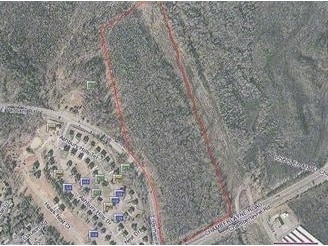
Property Record
100 E Parham Rd, Richmond, VA 23227


This Property Is For Sale
Property Detail
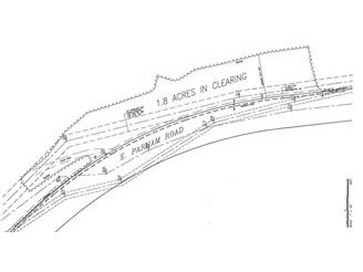
100 E Parham Rd
794-760-3423
00540A0000 0004B; US RT#301 PARHAM RD AC 51.284 PAR B 5 A1 4
Commercialacreage
HENRICO
MIXED
Virginia
AE The base floodplain where base flood elevations are provided. AE Zones are now used on new format FIRMs instead of A1-A30 Zones.
51.28 AC
2026
Parham East
2026
Richmond VA
200806
Richmond, VA
NEARBY LISTINGS FOR SALE OR LEASE
DEMOGRAPHICS near 100 E Parham Rd
1 mile
3 mile
5 mile
2025 Total Population
2,811
43,584
137,399
2030 Population
2,881
44,929
141,517
Pop Growth 2025-2030
+ 2.49%
+ 3.09%
+ 3.00%
Average Age
46
41
42
2025 Total Households
1,108
17,608
56,595
HH Growth 2025-2030
+ 2.53%
+ 2.98%
+ 3.10%
Median Household Inc
$106,979
$97,436
$87,628
Avg Household Size
2.50
2.40
2.30
2025 Avg HH Vehicles
3.00
2.00
2.00
Median Home Value
$356,214
$354,057
$344,784
Median Year Built
1981
1988
1978
Nearby Places
Map Layers
Map Styles
 Street
 Aerial
Layers
 Traffic
 Biking
Places
Listings with unknown addresses are not visible on the map
- Restaurants
- Banks
- Shops
- Fitness
- Groceries
PUBLIC TRANSPORTATION
COMMUTER RAIL
Richmond Staples Mill Road Amtrak Station (Carolinian - Amtrak, Northeast Regional - Amtrak, Palmetto - Amtrak, Silver Meteor - Amtrak)
Drive
Walk
Distance
Richmond Staples Mill Road Amtrak Station (Carolinian - Amtrak, Northeast Regional - Amtrak, Palmetto - Amtrak, Silver Meteor - Amtrak)
11 min
5.7 mi
AIRPORT
Richmond International
Drive
Walk
Distance
Richmond International
23 min
16.0 mi
Freight Ports
Virginia Port Authority - Richmond
Drive
Walk
Distance
Virginia Port Authority - Richmond
25 min
16.9 mi
Nearby Properties
Address
Land Use
TOTAL SIZE
Lot Size
Zoning
Address
Land Use
TOTAL SIZE
Lot Size
Zoning
2,645,407 SF
116.30 AC
M2-C
Address
Land Use
TOTAL SIZE
Lot Size
Zoning
136.01 AC
A-1
Address
Land Use
TOTAL SIZE
Lot Size
Zoning
436,148 SF
12.73 AC
B-1
Address
Land Use
TOTAL SIZE
Lot Size
Zoning
612 SF
46.83 AC
O-S
Address
Land Use
TOTAL SIZE
Lot Size
Zoning
104,972 SF
108.49 AC
MIXED
Address
Land Use
TOTAL SIZE
Lot Size
Zoning
347,648 SF
24.75 AC
R-5
Address
Land Use
TOTAL SIZE
Lot Size
Zoning
74,708 SF
13.50 AC
R-6C
Address
Land Use
TOTAL SIZE
Lot Size
Zoning
186,034 SF
1 AC
B-3C
Address
Land Use
TOTAL SIZE
Lot Size
Zoning
162,972 SF
1 AC
R-6C
Address
Land Use
TOTAL SIZE
Lot Size
Zoning
135,874 SF
31.99 AC
MIXED
Address
Land Use
TOTAL SIZE
Lot Size
Zoning
110,790 SF
37.61 AC
R-2A
Address
Land Use
TOTAL SIZE
Lot Size
Zoning
611 SF
71.86 AC
MIXED
Address
Land Use
TOTAL SIZE
Lot Size
Zoning
180,070 SF
17.13 AC
R-5
Address
Land Use
TOTAL SIZE
Lot Size
Zoning
104,023 SF
301 AC
MIXED
Address
Land Use
TOTAL SIZE
Lot Size
Zoning
1,249,190 SF
138.66 AC
M-2
Address
Land Use
TOTAL SIZE
Lot Size
Zoning
2,145 SF
4.54 AC
B-1
Address
Land Use
TOTAL SIZE
Lot Size
Zoning
39.96 AC
A-1
Address
Land Use
TOTAL SIZE
Lot Size
Zoning
160,000 SF
25 AC
M-1
Address
Land Use
TOTAL SIZE
Lot Size
Zoning
228,744 SF
21.11 AC
R-5
Address
Land Use
TOTAL SIZE
Lot Size
Zoning
227,008 SF
20.94 AC
R-5
Address
Land Use
TOTAL SIZE
Lot Size
Zoning
138,140 SF
7.66 AC
R-6
Address
Land Use
TOTAL SIZE
Lot Size
Zoning
216,900 SF
13.41 AC
R-6
Address
Land Use
TOTAL SIZE
Lot Size
Zoning
112,893 SF
58.52 AC
MIXED
Address
Land Use
TOTAL SIZE
Lot Size
Zoning
7,295 SF
72.17 AC
Address
Land Use
TOTAL SIZE
Lot Size
Zoning
143,800 SF
11.58 AC
R-5
Address
Land Use
TOTAL SIZE
Lot Size
Zoning
23.23 AC
M-1
Address
Land Use
TOTAL SIZE
Lot Size
Zoning
23.60 AC
R-1
Address
Land Use
TOTAL SIZE
Lot Size
Zoning
107,488 SF
9.89 AC
R-5
Address
Land Use
TOTAL SIZE
Lot Size
Zoning
204,358 SF
25.99 AC
B-3
Address
Land Use
TOTAL SIZE
Lot Size
Zoning
16,954 SF
1 AC
MIXED
The World's #1 Commercial Real Estate Marketplace
Connect with us
© 2026 CoStar Group
The information above has been obtained from sources believed reliable. While we do not doubt its accuracy we have not verified it and make no guarantee, warranty or representation about it. It is your responsibility to independently confirm its accuracy and completeness. Any projections, opinions, assumptions, or estimates used are for example only and do not represent the current or future performance of the property. The value of this transaction to you depends on tax and other factors which should be evaluated by your tax, financial, and legal advisors. You and your advisors should conduct a careful, independent investigation of the property to determine to your satisfaction the suitability of the property for your needs.