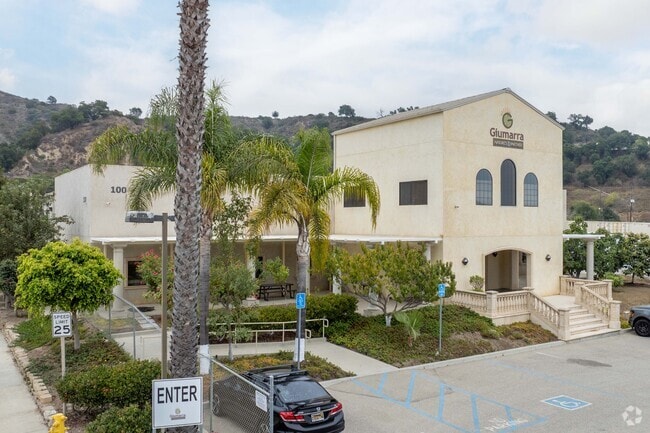
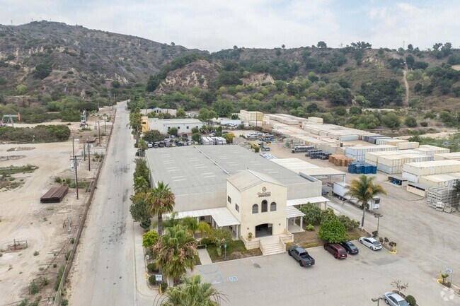
Property Record
100 E Shell Rd, Ventura, CA 93001

Property Detail
100 E Shell Rd
Oxnard-Thousand Oaks-Ventura, CA
LOT: 2 REF: 68 PM 27
063-0-220-145
VENTURA
Warehouse
California
B and X Area of moderate flood hazard, usually the area between the limits of the 100-year and 500-year floods.
2
2024
3.46 AC
2025
Ventura
002302
Los Angeles
25,362 SF
NEARBY LISTINGS FOR SALE OR LEASE
DEMOGRAPHICS near 100 E Shell Rd
1 mile
3 mile
5 mile
2024 Total Population
5,212
25,514
60,469
2029 Population
5,221
25,569
60,940
Pop Growth 2024-2029
+ 0.17%
+ 0.22%
+ 0.78%
Average Age
40
40
43
2024 Total Households
1,738
9,549
23,759
HH Growth 2024-2029
+ 0.06%
+ 0.19%
+ 0.80%
Median Household Inc
$126,949
$84,629
$100,403
Avg Household Size
2.80
2.50
2.40
2024 Avg HH Vehicles
2.00
2.00
2.00
Median Home Value
$753,992
$853,225
$900,173
Median Year Built
1984
1966
1964
Nearby Places
Map Layers
Map Styles
 Street
 Aerial
Transit
 Traffic
 Biking
Places
Listings with unknown addresses are not visible on the map
- Restaurants
- Banks
- Shops
- Fitness
- Groceries
PUBLIC TRANSPORTATION
COMMUTER RAIL
Drive
Walk
Distance
8 min
3.7 mi
AIRPORT
Santa Barbara Municipal
Drive
Walk
Distance
Santa Barbara Municipal
48 min
39.6 mi
Freight Ports
The Port of Hueneme
Drive
Walk
Distance
The Port of Hueneme
26 min
16.5 mi
Nearby Properties
Address
Land Use
TOTAL SIZE
Lot Size
Zoning
Address
Land Use
TOTAL SIZE
Lot Size
Zoning
Address
Land Use
TOTAL SIZE
Lot Size
Zoning
7,280 SF
5.38 AC
C-T-O
Address
Land Use
TOTAL SIZE
Lot Size
Zoning
2.89 AC
C-T-O
Address
Land Use
TOTAL SIZE
Lot Size
Zoning
639.79 AC
Address
Land Use
TOTAL SIZE
Lot Size
Zoning
11,444 SF
6.57 AC
Address
Land Use
TOTAL SIZE
Lot Size
Zoning
732 SF
0.51 AC
DR
Address
Land Use
TOTAL SIZE
Lot Size
Zoning
0.84 AC
Address
Land Use
TOTAL SIZE
Lot Size
Zoning
57,554 SF
0.58 AC
Address
Land Use
TOTAL SIZE
Lot Size
Zoning
9,572 SF
1.91 AC
MULT
Address
Land Use
TOTAL SIZE
Lot Size
Zoning
43,498 SF
1.67 AC
R33
Address
Land Use
TOTAL SIZE
Lot Size
Zoning
19,709 SF
0.14 AC
DC
Address
Land Use
TOTAL SIZE
Lot Size
Zoning
168 SF
7.87 AC
M3
Address
Land Use
TOTAL SIZE
Lot Size
Zoning
19,431 SF
0.59 AC
DR
Address
Land Use
TOTAL SIZE
Lot Size
Zoning
38,456 SF
1.49 AC
R33
Address
Land Use
TOTAL SIZE
Lot Size
Zoning
1.33 AC
DC
Address
Land Use
TOTAL SIZE
Lot Size
Zoning
29,058 SF
1.18 AC
C2
Address
Land Use
TOTAL SIZE
Lot Size
Zoning
Address
Land Use
TOTAL SIZE
Lot Size
Zoning
3,596 SF
1.19 AC
Address
Land Use
TOTAL SIZE
Lot Size
Zoning
3.60 AC
8
Address
Land Use
TOTAL SIZE
Lot Size
Zoning
1.40 AC
7
Address
Land Use
TOTAL SIZE
Lot Size
Zoning
5.10 AC
Address
Land Use
TOTAL SIZE
Lot Size
Zoning
1.54 AC
Address
Land Use
TOTAL SIZE
Lot Size
Zoning
0.77 AC
7
Address
Land Use
TOTAL SIZE
Lot Size
Zoning
11,970 SF
5.18 AC
M1
Address
Land Use
TOTAL SIZE
Lot Size
Zoning
0.88 AC
Address
Land Use
TOTAL SIZE
Lot Size
Zoning
21,700 SF
1.89 AC
MXD
Address
Land Use
TOTAL SIZE
Lot Size
Zoning
462 SF
0.77 AC
C-2
Address
Land Use
TOTAL SIZE
Lot Size
Zoning
20,600 SF
5.92 AC
M2
Address
Land Use
TOTAL SIZE
Lot Size
Zoning
19,605 SF
0.56 AC
DC
The World's #1 Commercial Real Estate Marketplace
Connect with us
© 2026 CoStar Group
The information above has been obtained from sources believed reliable. While we do not doubt its accuracy we have not verified it and make no guarantee, warranty or representation about it. It is your responsibility to independently confirm its accuracy and completeness. Any projections, opinions, assumptions, or estimates used are for example only and do not represent the current or future performance of the property. The value of this transaction to you depends on tax and other factors which should be evaluated by your tax, financial, and legal advisors. You and your advisors should conduct a careful, independent investigation of the property to determine to your satisfaction the suitability of the property for your needs.