Property Record
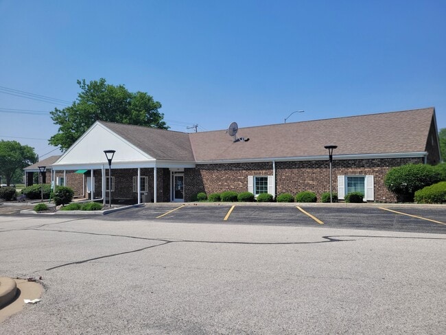
100 E Sunset Dr, Waukesha, WI 53189


Current Lease Availabilities
NEARBY LISTINGS FOR SALE OR LEASE
Property Detail
100 E Sunset Dr
Milwaukee-Waukesha-West Allis, WI
Seitz Estates Sub
WAKC-1339-973
SEC SW11 T6N R19E COM S LI SEC 600.19 E OF SW COR, N0 315 W60.02, S88 30 W510.2 TO BEG, N45 4637 W79.55, N0 315 W163.03, N88 30 E140, S0 315 E220 TO N LI SUNSET DR, W TO BEG V1156 P597 DEEDS
Commercialnec
Waukesha
X
Wisconsin
55133C0326H
23
2024
0.67 AC
2024
Central Waukesha
202400
Milwaukee/Madison
6,108 SF
DEMOGRAPHICS near 100 E Sunset Dr
1 Mile
3 Mile
5 Mile
2024 Total Population
11,040
62,928
101,980
2029 Population
11,464
65,230
105,581
Pop Growth 2024-2029
+ 3.84%
+ 3.66%
+ 3.53%
Average Age
37
40
41
2024 Total Households
4,325
26,742
42,932
HH Growth 2024-2029
+ 3.98%
+ 3.82%
+ 3.65%
Median Household Inc
$71,814
$72,220
$78,907
Avg Household Size
2.40
2.20
2.30
2024 Avg HH Vehicles
2.00
2.00
2.00
Median Home Value
$220,404
$251,737
$281,763
Median Year Built
1969
1975
1979
Nearby Places
Map Layers
Map Styles
 Street
 Aerial
- Restaurants
- Banks
- Shops
- Fitness
- Groceries
PUBLIC TRANSPORTATION
AIRPORT
General Mitchell International
DRIVE
WALK
Distance
General Mitchell International
36 min
21.1 mi
Nearby Properties
Address
Land Use
TOTAL SIZE
Lot Size
Zoning
Address
Land Use
TOTAL SIZE
Lot Size
Zoning
21.73 AC
M-1
Address
Land Use
TOTAL SIZE
Lot Size
Zoning
23.09 AC
B-1(PUD),C
Address
Land Use
TOTAL SIZE
Lot Size
Zoning
71.18 AC
M-2
Address
Land Use
TOTAL SIZE
Lot Size
Zoning
68,591 SF
2.97 AC
RM-3(PUD)
Address
Land Use
TOTAL SIZE
Lot Size
Zoning
6.56 AC
I-1
Address
Land Use
TOTAL SIZE
Lot Size
Zoning
237,267 SF
16.14 AC
B-5
Address
Land Use
TOTAL SIZE
Lot Size
Zoning
19 AC
RM-2
Address
Land Use
TOTAL SIZE
Lot Size
Zoning
91,322 SF
8.48 AC
B-4
Address
Land Use
TOTAL SIZE
Lot Size
Zoning
110,992 SF
12.15 AC
RM-1(PUD)
Address
Land Use
TOTAL SIZE
Lot Size
Zoning
187,050 SF
24.37 AC
B-5, C-1
Address
Land Use
TOTAL SIZE
Lot Size
Zoning
61,299 SF
6.59 AC
RM-2(PUD)
Address
Land Use
TOTAL SIZE
Lot Size
Zoning
28,942 SF
2.31 AC
B-3(22.52)
Address
Land Use
TOTAL SIZE
Lot Size
Zoning
79,529 SF
23.85 AC
I-1
Address
Land Use
TOTAL SIZE
Lot Size
Zoning
29.41 AC
B-5(PUD)
Address
Land Use
TOTAL SIZE
Lot Size
Zoning
4.21 AC
B-5(PUD)
Address
Land Use
TOTAL SIZE
Lot Size
Zoning
24,981 SF
1.79 AC
B-3(22.52)
Address
Land Use
TOTAL SIZE
Lot Size
Zoning
102,333 SF
11.99 AC
B-5(PUD)
Address
Land Use
TOTAL SIZE
Lot Size
Zoning
11.11 AC
B-5
Address
Land Use
TOTAL SIZE
Lot Size
Zoning
0.81 AC
B-2
Address
Land Use
TOTAL SIZE
Lot Size
Zoning
47,353 SF
5.41 AC
RM-2(PUD)
Address
Land Use
TOTAL SIZE
Lot Size
Zoning
111,624 SF
12.91 AC
RM-3(PUD)
Address
Land Use
TOTAL SIZE
Lot Size
Zoning
10.31 AC
B-5
Address
Land Use
TOTAL SIZE
Lot Size
Zoning
1.74 AC
RM-3(PUD)
Address
Land Use
TOTAL SIZE
Lot Size
Zoning
16.10 AC
M-2
Address
Land Use
TOTAL SIZE
Lot Size
Zoning
4.50 AC
B-5(PUD)
Address
Land Use
TOTAL SIZE
Lot Size
Zoning
24,684 SF
1.56 AC
RM-3(PUD)
Address
Land Use
TOTAL SIZE
Lot Size
Zoning
132,634 SF
9.25 AC
B-5(PUD)
Address
Land Use
TOTAL SIZE
Lot Size
Zoning
9.63 AC
B-5(PUD)
Address
Land Use
TOTAL SIZE
Lot Size
Zoning
25,317 SF
3.79 AC
RM-2(PUD),
Address
Land Use
TOTAL SIZE
Lot Size
Zoning
11.32 AC
M2
The World's #1 Commercial Real Estate Marketplace
Connect with us
© 2025 CoStar Group
The information above has been obtained from sources believed reliable. While we do not doubt its accuracy we have not verified it and make no guarantee, warranty or representation about it. It is your responsibility to independently confirm its accuracy and completeness. Any projections, opinions, assumptions, or estimates used are for example only and do not represent the current or future performance of the property. The value of this transaction to you depends on tax and other factors which should be evaluated by your tax, financial, and legal advisors. You and your advisors should conduct a careful, independent investigation of the property to determine to your satisfaction the suitability of the property for your needs.