Property Record
100 E Tiverton Way, Lexington, KY 40517
NEARBY LISTINGS FOR SALE OR LEASE
Property Detail
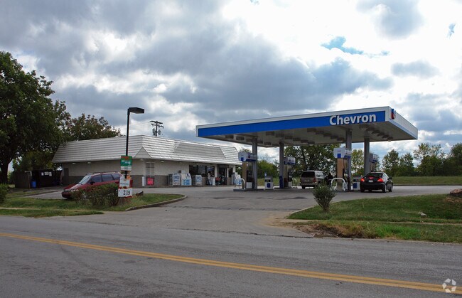
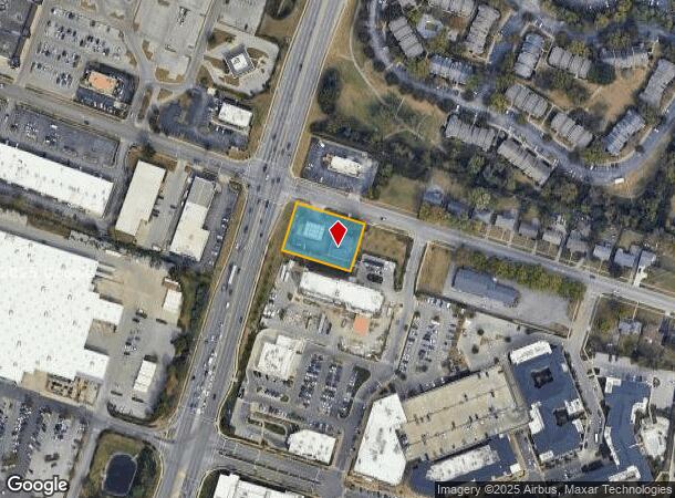
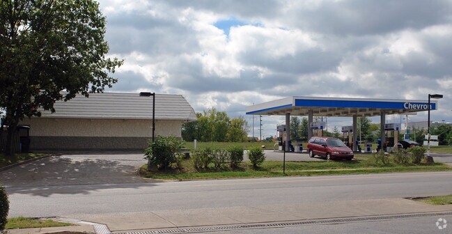
100 E Tiverton Way
Lexington-Fayette, KY
Devondale
22250900
C-774 DEVONDALE LOT 1; BOOK: 3451 PAGE: 461
Conveniencestore
Fayette
X
Kentucky
2100670207F
1
2025
0.31 AC
2025
East Lexington/Fayette
004103
Lexington/Fayette
3,000 SF
DEMOGRAPHICS near 100 E Tiverton Way
1 Mile
3 Mile
5 Mile
2024 Total Population
13,030
95,056
200,373
2029 Population
12,931
94,574
200,086
Pop Growth 2024-2029
(0.76%)
(0.51%)
(0.14%)
Average Age
38
39
38
2024 Total Households
5,937
41,400
85,610
HH Growth 2024-2029
(0.84%)
(0.55%)
(0.16%)
Median Household Inc
$63,385
$67,233
$60,880
Avg Household Size
2.20
2.20
2.20
2024 Avg HH Vehicles
2.00
2.00
2.00
Median Home Value
$205,845
$253,348
$270,774
Median Year Built
1992
1982
1980
Nearby Places
Map Layers
Map Styles
 Street
 Aerial
- Restaurants
- Banks
- Shops
- Fitness
- Groceries
PUBLIC TRANSPORTATION
AIRPORT
Blue Grass
DRIVE
WALK
Distance
Blue Grass
17 min
9.8 mi
Freight Ports
Port of Toledo
DRIVE
WALK
Distance
Port of Toledo
343 min
292.4 mi
Nearby Properties
Address
Land Use
TOTAL SIZE
Lot Size
Zoning
Address
Land Use
TOTAL SIZE
Lot Size
Zoning
635,961 SF
23.52 AC
P-1
Address
Land Use
TOTAL SIZE
Lot Size
Zoning
76,441 SF
63.86 AC
A-U
Address
Land Use
TOTAL SIZE
Lot Size
Zoning
319,500 SF
0.25 AC
P-1
Address
Land Use
TOTAL SIZE
Lot Size
Zoning
318,370 SF
17.79 AC
B-6P
Address
Land Use
TOTAL SIZE
Lot Size
Zoning
4,299 SF
18.43 AC
R-4
Address
Land Use
TOTAL SIZE
Lot Size
Zoning
8,001 SF
32.59 AC
MU-3
Address
Land Use
TOTAL SIZE
Lot Size
Zoning
144,866 SF
14.83 AC
B-6P
Address
Land Use
TOTAL SIZE
Lot Size
Zoning
238,393 SF
9.83 AC
B-6P
Address
Land Use
TOTAL SIZE
Lot Size
Zoning
5,650 SF
22.46 AC
R-3
Address
Land Use
TOTAL SIZE
Lot Size
Zoning
22.10 AC
R-3
Address
Land Use
TOTAL SIZE
Lot Size
Zoning
12,767 SF
14.39 AC
R-3
Address
Land Use
TOTAL SIZE
Lot Size
Zoning
41,040 SF
14.77 AC
R-4
Address
Land Use
TOTAL SIZE
Lot Size
Zoning
184,756 SF
4.43 AC
MU-3
Address
Land Use
TOTAL SIZE
Lot Size
Zoning
91,484 SF
14.72 AC
B-6P
Address
Land Use
TOTAL SIZE
Lot Size
Zoning
7,402 SF
18.83 AC
R-4
Address
Land Use
TOTAL SIZE
Lot Size
Zoning
137,905 SF
23.79 AC
B-6P
Address
Land Use
TOTAL SIZE
Lot Size
Zoning
59,586 SF
5.37 AC
R-4
Address
Land Use
TOTAL SIZE
Lot Size
Zoning
6.25 AC
A-U
Address
Land Use
TOTAL SIZE
Lot Size
Zoning
123,221 SF
17.32 AC
R-1B
Address
Land Use
TOTAL SIZE
Lot Size
Zoning
28,776 SF
13.83 AC
B-1
Address
Land Use
TOTAL SIZE
Lot Size
Zoning
73,590 SF
13.31 AC
R-1T
Address
Land Use
TOTAL SIZE
Lot Size
Zoning
25,880 SF
0.78 AC
P-1
Address
Land Use
TOTAL SIZE
Lot Size
Zoning
222,168 SF
26.49 AC
B-6P
Address
Land Use
TOTAL SIZE
Lot Size
Zoning
160,800 SF
74.22 AC
R-1C
Address
Land Use
TOTAL SIZE
Lot Size
Zoning
14,928 SF
8.75 AC
R-3
Address
Land Use
TOTAL SIZE
Lot Size
Zoning
4,406 SF
28.12 AC
R-3
Address
Land Use
TOTAL SIZE
Lot Size
Zoning
2,770 SF
15.20 AC
R-4
Address
Land Use
TOTAL SIZE
Lot Size
Zoning
156,350 SF
18.83 AC
B-6P
Address
Land Use
TOTAL SIZE
Lot Size
Zoning
178,160 SF
14.62 AC
R-3
Address
Land Use
TOTAL SIZE
Lot Size
Zoning
219,320 SF
8.35 AC
R-4
The World's #1 Commercial Real Estate Marketplace
Connect with us
© 2025 CoStar Group
The information above has been obtained from sources believed reliable. While we do not doubt its accuracy we have not verified it and make no guarantee, warranty or representation about it. It is your responsibility to independently confirm its accuracy and completeness. Any projections, opinions, assumptions, or estimates used are for example only and do not represent the current or future performance of the property. The value of this transaction to you depends on tax and other factors which should be evaluated by your tax, financial, and legal advisors. You and your advisors should conduct a careful, independent investigation of the property to determine to your satisfaction the suitability of the property for your needs.