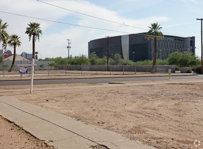
Property Record
1301 N 2Nd St, Phoenix, AZ 85004

NEARBY LISTINGS FOR SALE OR LEASE
Property Detail
1301 N 2Nd St
Phoenix-Mesa-Chandler, AZ
Central Place Sub Of Blk 17
111-35-102
CENTRAL PLACE SUB OF BLK 17 MCR 3-46
Commercialacreage
Maricopa
X
Arizona
04013C2205L
21
2025
0.05 AC
2025
Midtown
113000
Phoenix
DEMOGRAPHICS near 1301 N 2Nd St
1 Mile
3 Mile
5 Mile
2024 Total Population
23,436
142,297
389,725
2029 Population
26,055
155,682
423,089
Pop Growth 2024-2029
+ 11.18%
+ 9.41%
+ 8.56%
Average Age
37
36
36
2024 Total Households
12,797
61,227
150,928
HH Growth 2024-2029
+ 11.84%
+ 9.87%
+ 9.06%
Median Household Inc
$58,239
$52,519
$54,102
Avg Household Size
1.70
2.20
2.40
2024 Avg HH Vehicles
1.00
1.00
2.00
Median Home Value
$517,012
$382,411
$363,155
Median Year Built
1978
1968
1970
Nearby Places
Map Layers
Map Styles
 Street
 Aerial
- Restaurants
- Banks
- Shops
- Fitness
- Groceries
PUBLIC TRANSPORTATION
TRANSIT/SUBWAY
McDowell/Central Ave (METRO Light Rail - Valley Metro (Phoenix Light Rail))
DRIVE
WALK
Distance
McDowell/Central Ave (METRO Light Rail - Valley Metro (Phoenix Light Rail))
1 min
4 min
0.2 mi
Roosevelt/Central Ave (METRO Light Rail - Valley Metro (Phoenix Light Rail))
DRIVE
WALK
Distance
Roosevelt/Central Ave (METRO Light Rail - Valley Metro (Phoenix Light Rail))
2 min
9 min
0.5 mi
Encanto/Central Ave (METRO Light Rail - Valley Metro (Phoenix Light Rail))
DRIVE
WALK
Distance
Encanto/Central Ave (METRO Light Rail - Valley Metro (Phoenix Light Rail))
2 min
15 min
0.8 mi
Van Buren/Central Ave (METRO Light Rail - Valley Metro (Phoenix Light Rail))
DRIVE
WALK
Distance
Van Buren/Central Ave (METRO Light Rail - Valley Metro (Phoenix Light Rail))
3 min
19 min
1.0 mi
Van Buren/1st Ave (METRO Light Rail - Valley Metro (Phoenix Light Rail))
DRIVE
WALK
Distance
Van Buren/1st Ave (METRO Light Rail - Valley Metro (Phoenix Light Rail))
3 min
20 min
1.0 mi
AIRPORT
Phoenix Sky Harbor International
DRIVE
WALK
Distance
Phoenix Sky Harbor International
12 min
6.1 mi
Phoenix-Mesa Gateway
DRIVE
WALK
Distance
Phoenix-Mesa Gateway
45 min
33.3 mi
SALE & LEASE HISTORY
LISTING DATE
SALE/LEASE

Sep 24, 2016
For Sale
Nearby Properties
Address
Land Use
TOTAL SIZE
Lot Size
Zoning
Address
Land Use
TOTAL SIZE
Lot Size
Zoning
582,073 SF
1.45 AC
C-C
Address
Land Use
TOTAL SIZE
Lot Size
Zoning
1.85 AC
Address
Land Use
TOTAL SIZE
Lot Size
Zoning
455,443 SF
3.21 AC
C-C
Address
Land Use
TOTAL SIZE
Lot Size
Zoning
997,436 SF
24.84 AC
DC
Address
Land Use
TOTAL SIZE
Lot Size
Zoning
24.15 AC
Address
Land Use
TOTAL SIZE
Lot Size
Zoning
339,909 SF
3 AC
C-C
Address
Land Use
TOTAL SIZE
Lot Size
Zoning
2,568,761 SF
48.36 AC
C-C
Address
Land Use
TOTAL SIZE
Lot Size
Zoning
437,102 SF
1.02 AC
C-2
Address
Land Use
TOTAL SIZE
Lot Size
Zoning
2,006,402 SF
18.66 AC
C-C
Address
Land Use
TOTAL SIZE
Lot Size
Zoning
2,334,671 SF
32.63 AC
C-2
Address
Land Use
TOTAL SIZE
Lot Size
Zoning
191,120 SF
1.43 AC
C-C
Address
Land Use
TOTAL SIZE
Lot Size
Zoning
1,636,025 SF
16.50 AC
C-DT
Address
Land Use
TOTAL SIZE
Lot Size
Zoning
1,748,324 SF
29.35 AC
M-H
Address
Land Use
TOTAL SIZE
Lot Size
Zoning
2,705,875 SF
133.42 AC
I-1
Address
Land Use
TOTAL SIZE
Lot Size
Zoning
577,883 SF
2.05 AC
C-DT
Address
Land Use
TOTAL SIZE
Lot Size
Zoning
568,512 SF
6.99 AC
C-DT
Address
Land Use
TOTAL SIZE
Lot Size
Zoning
671,803 SF
2.99 AC
C-DT
Address
Land Use
TOTAL SIZE
Lot Size
Zoning
833,326 SF
1.31 AC
C-DT
Address
Land Use
TOTAL SIZE
Lot Size
Zoning
940,067 SF
12.22 AC
DTCBIO
Address
Land Use
TOTAL SIZE
Lot Size
Zoning
536,452 SF
0.58 AC
C-DT
Address
Land Use
TOTAL SIZE
Lot Size
Zoning
981,015 SF
2.83 AC
C-DT
Address
Land Use
TOTAL SIZE
Lot Size
Zoning
429,457 SF
9.41 AC
C-DT
Address
Land Use
TOTAL SIZE
Lot Size
Zoning
384,291 SF
2.68 AC
C-DT
Address
Land Use
TOTAL SIZE
Lot Size
Zoning
925,428 SF
86.02 AC
M-H
Address
Land Use
TOTAL SIZE
Lot Size
Zoning
782,912 SF
1.12 AC
C-DT
Address
Land Use
TOTAL SIZE
Lot Size
Zoning
550,269 SF
2.05 AC
DTCBCORE
Address
Land Use
TOTAL SIZE
Lot Size
Zoning
727,848 SF
0.06 AC
C-DT
Address
Land Use
TOTAL SIZE
Lot Size
Zoning
913,637 SF
35.53 AC
M-H
Address
Land Use
TOTAL SIZE
Lot Size
Zoning
569,100 SF
0.95 AC
C-DT
Address
Land Use
TOTAL SIZE
Lot Size
Zoning
222,983 SF
1.61 AC
C-DT
The World's #1 Commercial Real Estate Marketplace
Connect with us
© 2026 CoStar Group
The information above has been obtained from sources believed reliable. While we do not doubt its accuracy we have not verified it and make no guarantee, warranty or representation about it. It is your responsibility to independently confirm its accuracy and completeness. Any projections, opinions, assumptions, or estimates used are for example only and do not represent the current or future performance of the property. The value of this transaction to you depends on tax and other factors which should be evaluated by your tax, financial, and legal advisors. You and your advisors should conduct a careful, independent investigation of the property to determine to your satisfaction the suitability of the property for your needs.