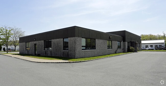
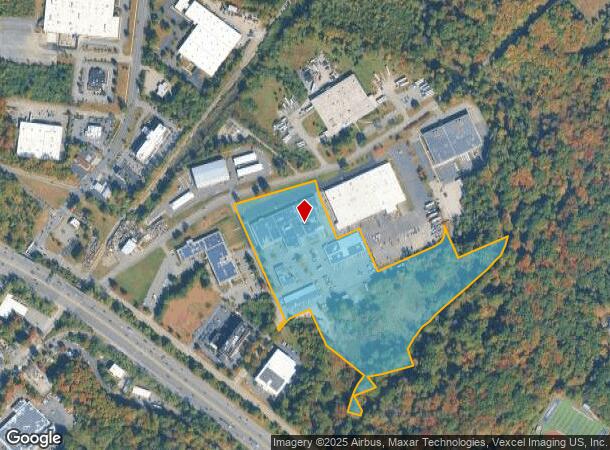
Property Record
90 Ford Rd, Denville, NJ 07834
NEARBY LISTINGS FOR SALE OR LEASE
Property Detail
90 Ford Rd
Northern New Jersey
Denville Technical Park Sec 01
Newark, NJ
Morris
08-62101-0000-00001
New Jersey
Industrialgeneral
1
2024
18.25 AC
2025
Western Morris
041400
DEMOGRAPHICS near 90 Ford Rd
1 Mile
3 Mile
5 Mile
2024 Total Population
6,968
47,517
124,973
2029 Population
6,952
47,705
125,336
Pop Growth 2024-2029
(0.23%)
+ 0.40%
+ 0.29%
Average Age
41
43
42
2024 Total Households
2,586
18,043
45,600
HH Growth 2024-2029
(0.35%)
+ 0.46%
+ 0.31%
Median Household Inc
$124,571
$125,841
$110,697
Avg Household Size
2.70
2.60
2.70
2024 Avg HH Vehicles
2.00
2.00
2.00
Median Home Value
$404,499
$426,039
$444,360
Median Year Built
1959
1965
1966
Nearby Places
Map Layers
Map Styles
 Street
 Aerial
- Restaurants
- Banks
- Shops
- Fitness
- Groceries
PUBLIC TRANSPORTATION
COMMUTER RAIL
Denville (Montclair-Boonton Line - NJ Transit Commuter Rail (NJ Transit), Morris & Essex Morristown Line - NJ Transit Commuter Rail (NJ Transit))
DRIVE
WALK
Distance
Denville (Montclair-Boonton Line - NJ Transit Commuter Rail (NJ Transit), Morris & Essex Morristown Line - NJ Transit Commuter Rail (NJ Transit))
6 min
2.6 mi
Mount Tabor (Morris & Essex Morristown Line - NJ Transit Commuter Rail (NJ Transit))
DRIVE
WALK
Distance
Mount Tabor (Morris & Essex Morristown Line - NJ Transit Commuter Rail (NJ Transit))
7 min
3.2 mi
AIRPORT
Newark Liberty International
DRIVE
WALK
Distance
Newark Liberty International
40 min
29.6 mi
Freight Ports
Maher Terminal
DRIVE
WALK
Distance
Maher Terminal
43 min
29.8 mi
SALE & LEASE HISTORY
LISTING DATE
SALE/LEASE

Sep 24, 2016
For Lease
Sep 06, 2018
For Lease
May 15, 2025
For Lease
Jan 30, 2017
For Lease
Jan 09, 2024
For Lease
Aug 25, 2017
For Lease
Nearby Properties
Address
Land Use
TOTAL SIZE
Lot Size
Zoning
Address
Land Use
TOTAL SIZE
Lot Size
Zoning
401,303 SF
59.54 AC
R-B
Address
Land Use
TOTAL SIZE
Lot Size
Zoning
24.83 AC
RM15
Address
Land Use
TOTAL SIZE
Lot Size
Zoning
5,686 SF
557.09 AC
M
Address
Land Use
TOTAL SIZE
Lot Size
Zoning
428,141 SF
12.30 AC
OB-3
Address
Land Use
TOTAL SIZE
Lot Size
Zoning
95,368 SF
33.81 AC
RMF8
Address
Land Use
TOTAL SIZE
Lot Size
Zoning
278,943 SF
45.85 AC
PED
Address
Land Use
TOTAL SIZE
Lot Size
Zoning
156,564 SF
19.66 AC
B-2
Address
Land Use
TOTAL SIZE
Lot Size
Zoning
11.90 AC
OB3
Address
Land Use
TOTAL SIZE
Lot Size
Zoning
44,600 SF
18.62 AC
R-B
Address
Land Use
TOTAL SIZE
Lot Size
Zoning
270,140 SF
51.78 AC
R-1B
Address
Land Use
TOTAL SIZE
Lot Size
Zoning
18.35 AC
RMF8
Address
Land Use
TOTAL SIZE
Lot Size
Zoning
19,436 SF
33.20 AC
PED
Address
Land Use
TOTAL SIZE
Lot Size
Zoning
180,636 SF
65.98 AC
I
Address
Land Use
TOTAL SIZE
Lot Size
Zoning
156,380 SF
9.72 AC
I
Address
Land Use
TOTAL SIZE
Lot Size
Zoning
20 AC
OBRL
Address
Land Use
TOTAL SIZE
Lot Size
Zoning
261,582 SF
18.38 AC
R-B
Address
Land Use
TOTAL SIZE
Lot Size
Zoning
38.15 AC
R-1
Address
Land Use
TOTAL SIZE
Lot Size
Zoning
378.93 AC
POS
Address
Land Use
TOTAL SIZE
Lot Size
Zoning
48,455 SF
8.66 AC
POS
Address
Land Use
TOTAL SIZE
Lot Size
Zoning
124,041 SF
13.72 AC
I
Address
Land Use
TOTAL SIZE
Lot Size
Zoning
30,638 SF
7.44 AC
B-3
Address
Land Use
TOTAL SIZE
Lot Size
Zoning
97,350 SF
8.28 AC
R-B
Address
Land Use
TOTAL SIZE
Lot Size
Zoning
7.77 AC
RMF
Address
Land Use
TOTAL SIZE
Lot Size
Zoning
9 AC
B-2A
Address
Land Use
TOTAL SIZE
Lot Size
Zoning
87,853 SF
12.42 AC
R-B
Address
Land Use
TOTAL SIZE
Lot Size
Zoning
181,056 SF
12.88 AC
R-B
Address
Land Use
TOTAL SIZE
Lot Size
Zoning
125,850 SF
30 AC
R-13
Address
Land Use
TOTAL SIZE
Lot Size
Zoning
72,374 SF
7.04 AC
ELRP
Address
Land Use
TOTAL SIZE
Lot Size
Zoning
187,852 SF
15 AC
R-B
Address
Land Use
TOTAL SIZE
Lot Size
Zoning
90,775 SF
4.35 AC
R-B
The World's #1 Commercial Real Estate Marketplace
Connect with us
© 2026 CoStar Group
The information above has been obtained from sources believed reliable. While we do not doubt its accuracy we have not verified it and make no guarantee, warranty or representation about it. It is your responsibility to independently confirm its accuracy and completeness. Any projections, opinions, assumptions, or estimates used are for example only and do not represent the current or future performance of the property. The value of this transaction to you depends on tax and other factors which should be evaluated by your tax, financial, and legal advisors. You and your advisors should conduct a careful, independent investigation of the property to determine to your satisfaction the suitability of the property for your needs.