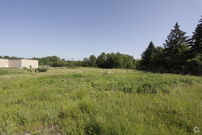
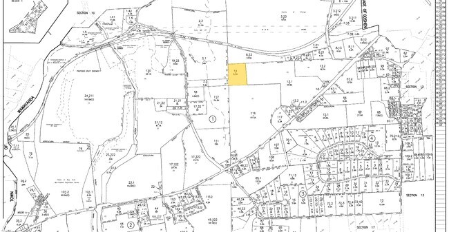
Property Record
100 Gate Schoolhouse Rd, New Hampton, NY 10958
NEARBY LISTINGS FOR SALE OR LEASE
Property Detail
100 Gate Schoolhouse Rd
Kiryas Joel-Poughkeepsie-Newburgh, NY
LTS A&B SEIFREID MP5435
333089-012-000-0001-071.220-0000
Orange
Agriculturalland
New York
X
71.12
36071C0269E
26.30 AC
2024
Middletown
2024
Northern New Jersey
011900
DEMOGRAPHICS near 100 Gate Schoolhouse Rd
1 Mile
3 Mile
5 Mile
2024 Total Population
728
12,813
61,918
2029 Population
737
13,073
63,124
Pop Growth 2024-2029
+ 1.24%
+ 2.03%
+ 1.95%
Average Age
42
44
40
2024 Total Households
156
4,485
22,673
HH Growth 2024-2029
+ 1.92%
+ 2.32%
+ 2.14%
Median Household Inc
$152,083
$102,313
$79,918
Avg Household Size
2.90
2.50
2.60
2024 Avg HH Vehicles
3.00
2.00
2.00
Median Home Value
$469,999
$355,134
$292,917
Median Year Built
1990
1976
1975
Nearby Places
Map Layers
Map Styles
 Street
 Aerial
- Restaurants
- Banks
- Shops
- Fitness
- Groceries
PUBLIC TRANSPORTATION
COMMUTER RAIL
Middletown New York (Bergen County/Port Jervis Line - NJ Transit Commuter Rail (NJ Transit), Main/Port Jervis Line - NJ Transit Commuter Rail (NJ Transit))
DRIVE
WALK
Distance
Middletown New York (Bergen County/Port Jervis Line - NJ Transit Commuter Rail (NJ Transit), Main/Port Jervis Line - NJ Transit Commuter Rail (NJ Transit))
17 min
8.8 mi
Campbell Hall (Bergen County/Port Jervis Line - NJ Transit Commuter Rail (NJ Transit), Main/Port Jervis Line - NJ Transit Commuter Rail (NJ Transit))
DRIVE
WALK
Distance
Campbell Hall (Bergen County/Port Jervis Line - NJ Transit Commuter Rail (NJ Transit), Main/Port Jervis Line - NJ Transit Commuter Rail (NJ Transit))
18 min
9.4 mi
AIRPORT
New York Stewart International
DRIVE
WALK
Distance
New York Stewart International
34 min
20.3 mi
Freight Ports
Maher Terminal
DRIVE
WALK
Distance
Maher Terminal
92 min
68.2 mi
SALE & LEASE HISTORY
LISTING DATE
SALE/LEASE

Sep 24, 2016
For Sale
Nearby Properties
Address
Land Use
TOTAL SIZE
Lot Size
Zoning
Address
Land Use
TOTAL SIZE
Lot Size
Zoning
101 AC
02069
Address
Land Use
TOTAL SIZE
Lot Size
Zoning
3,304 SF
80.10 AC
02069
Address
Land Use
TOTAL SIZE
Lot Size
Zoning
371,790 SF
169.40 AC
01092
Address
Land Use
TOTAL SIZE
Lot Size
Zoning
433,953 SF
90.64 AC
04200
Address
Land Use
TOTAL SIZE
Lot Size
Zoning
82 AC
04300
Address
Land Use
TOTAL SIZE
Lot Size
Zoning
47.80 AC
01092
Address
Land Use
TOTAL SIZE
Lot Size
Zoning
188,237 SF
9.60 AC
01092
Address
Land Use
TOTAL SIZE
Lot Size
Zoning
159,871 SF
23.20 AC
01092
Address
Land Use
TOTAL SIZE
Lot Size
Zoning
74,932 SF
84.30 AC
01092
Address
Land Use
TOTAL SIZE
Lot Size
Zoning
147,312 SF
10.60 AC
04023
Address
Land Use
TOTAL SIZE
Lot Size
Zoning
116,353 SF
22.50 AC
2034
Address
Land Use
TOTAL SIZE
Lot Size
Zoning
95,273 SF
31.60 AC
02069
Address
Land Use
TOTAL SIZE
Lot Size
Zoning
26,659 SF
15.80 AC
MC 2
Address
Land Use
TOTAL SIZE
Lot Size
Zoning
52,730 SF
13.70 AC
04092
Address
Land Use
TOTAL SIZE
Lot Size
Zoning
64 AC
01092
Address
Land Use
TOTAL SIZE
Lot Size
Zoning
14.70 AC
MC 1
Address
Land Use
TOTAL SIZE
Lot Size
Zoning
142,425 SF
12.40 AC
04300
Address
Land Use
TOTAL SIZE
Lot Size
Zoning
42,944 SF
4.90 AC
04300
Address
Land Use
TOTAL SIZE
Lot Size
Zoning
40,918 SF
3.60 AC
04011
Address
Land Use
TOTAL SIZE
Lot Size
Zoning
1,044 SF
43.10 AC
Address
Land Use
TOTAL SIZE
Lot Size
Zoning
60,918 SF
5.80 AC
4300
Address
Land Use
TOTAL SIZE
Lot Size
Zoning
45,090 SF
4.60 AC
100
Address
Land Use
TOTAL SIZE
Lot Size
Zoning
109,734 SF
14.90 AC
4300
Address
Land Use
TOTAL SIZE
Lot Size
Zoning
60,824 SF
8.90 AC
4300
Address
Land Use
TOTAL SIZE
Lot Size
Zoning
241,841 SF
31.30 AC
04023
Address
Land Use
TOTAL SIZE
Lot Size
Zoning
93,176 SF
19.20 AC
04300
Address
Land Use
TOTAL SIZE
Lot Size
Zoning
20.40 AC
04300
Address
Land Use
TOTAL SIZE
Lot Size
Zoning
56,982 SF
14.90 AC
4300
Address
Land Use
TOTAL SIZE
Lot Size
Zoning
Address
Land Use
TOTAL SIZE
Lot Size
Zoning
80,054 SF
3.90 AC
2034
The World's #1 Commercial Real Estate Marketplace
Connect with us
© 2026 CoStar Group
The information above has been obtained from sources believed reliable. While we do not doubt its accuracy we have not verified it and make no guarantee, warranty or representation about it. It is your responsibility to independently confirm its accuracy and completeness. Any projections, opinions, assumptions, or estimates used are for example only and do not represent the current or future performance of the property. The value of this transaction to you depends on tax and other factors which should be evaluated by your tax, financial, and legal advisors. You and your advisors should conduct a careful, independent investigation of the property to determine to your satisfaction the suitability of the property for your needs.