Property Record
100 Hope St, Cumberland, RI 02864
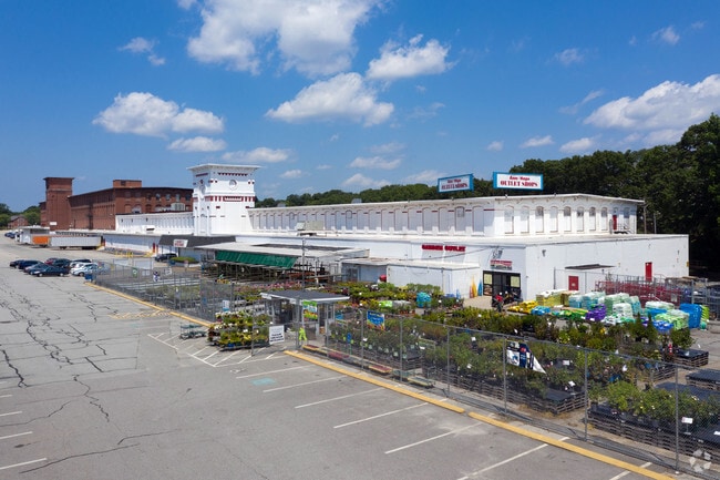
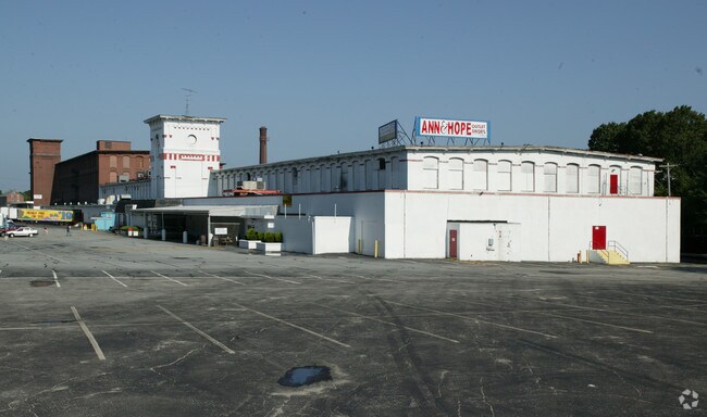
Property Detail
100 Hope St
CUMB-000011-000159-000000
Providence
Industrialgeneral
Rhode Island
60
14.24 AC
B and X Area of moderate flood hazard, usually the area between the limits of the 100-year and 500-year floods.
Lincoln
2025
Providence
2025
Providence-Warwick, RI-MA
011405
NEARBY LISTINGS FOR SALE OR LEASE
DEMOGRAPHICS near 100 Hope St
1 mile
3 mile
5 mile
2025 Total Population
10,299
88,882
207,380
2030 Population
10,561
90,891
212,832
Pop Growth 2025-2030
+ 2.54%
+ 2.26%
+ 2.63%
Average Age
42
40
41
2025 Total Households
4,096
34,509
82,656
HH Growth 2025-2030
+ 2.49%
+ 2.30%
+ 2.64%
Median Household Inc
$90,021
$75,497
$81,141
Avg Household Size
2.50
2.50
2.40
2025 Avg HH Vehicles
2.00
2.00
2.00
Median Home Value
$395,093
$397,868
$395,762
Median Year Built
1964
1958
1960
Nearby Places
Map Layers
Map Styles
 Street
 Aerial
Layers
 Traffic
 Biking
Places
Listings with unknown addresses are not visible on the map
- Restaurants
- Banks
- Shops
- Fitness
- Groceries
PUBLIC TRANSPORTATION
COMMUTER RAIL
Drive
Walk
Distance
7 min
3.5 mi
South Attleboro (Providence/Stoughton Line - Massachusetts Bay Transportation Authority Commuter Rail (Purple Line))
Drive
Walk
Distance
South Attleboro (Providence/Stoughton Line - Massachusetts Bay Transportation Authority Commuter Rail (Purple Line))
9 min
4.4 mi
AIRPORT
Rhode Island Tf Green International
Drive
Walk
Distance
Rhode Island Tf Green International
30 min
16.3 mi
Worcester Regional
Drive
Walk
Distance
Worcester Regional
59 min
41.4 mi
General Edward Lawrence Logan International
Drive
Walk
Distance
General Edward Lawrence Logan International
65 min
44.2 mi
Freight Ports
Port of Davisville, RI
Drive
Walk
Distance
Port of Davisville, RI
46 min
28.6 mi
SALE & LEASE HISTORY
LISTING DATE
SALE/LEASE

Sep 25, 2016
For Lease
Apr 28, 2020
For Sale
Nearby Properties
Address
Land Use
TOTAL SIZE
Lot Size
Zoning
Address
Land Use
TOTAL SIZE
Lot Size
Zoning
170,531 SF
3 AC
M-2
Address
Land Use
TOTAL SIZE
Lot Size
Zoning
28,208 SF
38.19 AC
PHB
Address
Land Use
TOTAL SIZE
Lot Size
Zoning
741,896 SF
27.75 AC
GU
Address
Land Use
TOTAL SIZE
Lot Size
Zoning
64.31 AC
C60
Address
Land Use
TOTAL SIZE
Lot Size
Zoning
168,150 SF
2.77 AC
PO
Address
Land Use
TOTAL SIZE
Lot Size
Zoning
4.60 AC
60
Address
Land Use
TOTAL SIZE
Lot Size
Zoning
14,841 SF
15.70 AC
PHB
Address
Land Use
TOTAL SIZE
Lot Size
Zoning
88,698 SF
1.44 AC
RM
Address
Land Use
TOTAL SIZE
Lot Size
Zoning
14.66 AC
CG
Address
Land Use
TOTAL SIZE
Lot Size
Zoning
10,920 SF
11.03 AC
Address
Land Use
TOTAL SIZE
Lot Size
Zoning
214,701 SF
3.14 AC
RE
Address
Land Use
TOTAL SIZE
Lot Size
Zoning
190,458 SF
16.30 AC
C60
Address
Land Use
TOTAL SIZE
Lot Size
Zoning
2.97 AC
MB
Address
Land Use
TOTAL SIZE
Lot Size
Zoning
341,251 SF
16.22 AC
60
Address
Land Use
TOTAL SIZE
Lot Size
Zoning
147,170 SF
2.23 AC
R-3
Address
Land Use
TOTAL SIZE
Lot Size
Zoning
15,086 SF
2.61 AC
C-2
Address
Land Use
TOTAL SIZE
Lot Size
Zoning
115,258 SF
10.08 AC
100
Address
Land Use
TOTAL SIZE
Lot Size
Zoning
97,858 SF
2.02 AC
R-3
Address
Land Use
TOTAL SIZE
Lot Size
Zoning
98,968 SF
1.66 AC
R-2
Address
Land Use
TOTAL SIZE
Lot Size
Zoning
105,878 SF
12.05 AC
C60
Address
Land Use
TOTAL SIZE
Lot Size
Zoning
189,308 SF
19.76 AC
I
Address
Land Use
TOTAL SIZE
Lot Size
Zoning
155,731 SF
41.03 AC
PHB
Address
Land Use
TOTAL SIZE
Lot Size
Zoning
126,073 SF
22.90 AC
C60
Address
Land Use
TOTAL SIZE
Lot Size
Zoning
2.23 AC
RE
Address
Land Use
TOTAL SIZE
Lot Size
Zoning
69,053 SF
0.87 AC
C-2
Address
Land Use
TOTAL SIZE
Lot Size
Zoning
27,264 SF
6.20 AC
Address
Land Use
TOTAL SIZE
Lot Size
Zoning
97,027 SF
12.02 AC
C60
Address
Land Use
TOTAL SIZE
Lot Size
Zoning
6 AC
120
Address
Land Use
TOTAL SIZE
Lot Size
Zoning
89,242 SF
14.65 AC
C60
Address
Land Use
TOTAL SIZE
Lot Size
Zoning
100,019 SF
10.37 AC
120
The World's #1 Commercial Real Estate Marketplace
Connect with us
© 2026 CoStar Group
The information above has been obtained from sources believed reliable. While we do not doubt its accuracy we have not verified it and make no guarantee, warranty or representation about it. It is your responsibility to independently confirm its accuracy and completeness. Any projections, opinions, assumptions, or estimates used are for example only and do not represent the current or future performance of the property. The value of this transaction to you depends on tax and other factors which should be evaluated by your tax, financial, and legal advisors. You and your advisors should conduct a careful, independent investigation of the property to determine to your satisfaction the suitability of the property for your needs.