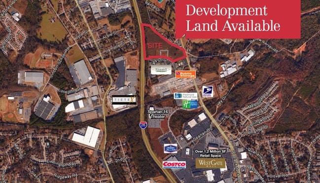
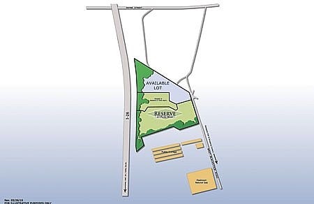
Property Record
100 Keats Dr, Spartanburg, SC 29301


Property Detail
100 Keats Dr
Spartanburg, SC
TRACT 1 BLUE RIDGE DEV SERVICES LLC PB 161-661 PB 167-435 & 788
6-17-11-058.00
Spartanburg
Commercialnec
South Carolina
B and X Area of moderate flood hazard, usually the area between the limits of the 100-year and 500-year floods.
3
0
17.04 AC
2025
West Side
021904
Greenville/Spartanburg
5,888 SF
NEARBY LISTINGS FOR SALE OR LEASE
DEMOGRAPHICS near 100 Keats Dr
1 mile
3 mile
5 mile
2025 Total Population
4,834
42,797
105,419
2030 Population
5,358
47,773
117,711
Pop Growth 2025-2030
+ 10.84%
+ 11.63%
+ 11.66%
Average Age
37
38
38
2025 Total Households
1,959
16,481
40,508
HH Growth 2025-2030
+ 10.87%
+ 11.74%
+ 11.93%
Median Household Inc
$55,563
$54,900
$53,346
Avg Household Size
2.40
2.40
2.40
2025 Avg HH Vehicles
2.00
2.00
2.00
Median Home Value
$182,491
$209,996
$214,517
Median Year Built
1986
1982
1984
Nearby Places
Map Layers
Map Styles
 Street
 Aerial
Layers
 Traffic
 Biking
Places
Listings with unknown addresses are not visible on the map
- Restaurants
- Banks
- Shops
- Fitness
- Groceries
PUBLIC TRANSPORTATION
COMMUTER RAIL
Drive
Walk
Distance
11 min
4.7 mi
AIRPORT
Greenville Spartanburg International
Drive
Walk
Distance
Greenville Spartanburg International
25 min
16.7 mi
SALE & LEASE HISTORY
LISTING DATE
SALE/LEASE

Sep 26, 2017
For Sale
Sep 24, 2016
For Sale
Jul 30, 2018
For Sale
Aug 16, 2017
For Sale
Nearby Properties
Address
Land Use
TOTAL SIZE
Lot Size
Zoning
Address
Land Use
TOTAL SIZE
Lot Size
Zoning
5,130 SF
19.69 AC
Address
Land Use
TOTAL SIZE
Lot Size
Zoning
3,352 SF
14 AC
Address
Land Use
TOTAL SIZE
Lot Size
Zoning
2,134 SF
27.72 AC
Address
Land Use
TOTAL SIZE
Lot Size
Zoning
50,096 SF
5.88 AC
Address
Land Use
TOTAL SIZE
Lot Size
Zoning
2,112 SF
5.26 AC
Address
Land Use
TOTAL SIZE
Lot Size
Zoning
100,000 SF
8.29 AC
Address
Land Use
TOTAL SIZE
Lot Size
Zoning
6,148 SF
4.18 AC
Address
Land Use
TOTAL SIZE
Lot Size
Zoning
3,171 SF
21.41 AC
Address
Land Use
TOTAL SIZE
Lot Size
Zoning
2,297 SF
42.76 AC
Address
Land Use
TOTAL SIZE
Lot Size
Zoning
128,755 SF
4.47 AC
Address
Land Use
TOTAL SIZE
Lot Size
Zoning
11,830 SF
16.87 AC
Address
Land Use
TOTAL SIZE
Lot Size
Zoning
Address
Land Use
TOTAL SIZE
Lot Size
Zoning
8,140 SF
20.42 AC
Address
Land Use
TOTAL SIZE
Lot Size
Zoning
30,016 SF
1.07 AC
Address
Land Use
TOTAL SIZE
Lot Size
Zoning
122,626 SF
7.70 AC
Address
Land Use
TOTAL SIZE
Lot Size
Zoning
37.35 AC
Address
Land Use
TOTAL SIZE
Lot Size
Zoning
402,619 SF
58.63 AC
Address
Land Use
TOTAL SIZE
Lot Size
Zoning
23,884 SF
3.90 AC
Address
Land Use
TOTAL SIZE
Lot Size
Zoning
1,475 SF
41.85 AC
Address
Land Use
TOTAL SIZE
Lot Size
Zoning
1,221,473 SF
36.50 AC
Address
Land Use
TOTAL SIZE
Lot Size
Zoning
227,480 SF
22.22 AC
Address
Land Use
TOTAL SIZE
Lot Size
Zoning
33,550 SF
3.77 AC
Address
Land Use
TOTAL SIZE
Lot Size
Zoning
101,622 SF
19.63 AC
Address
Land Use
TOTAL SIZE
Lot Size
Zoning
39.65 AC
Address
Land Use
TOTAL SIZE
Lot Size
Zoning
2,831 SF
10.07 AC
Address
Land Use
TOTAL SIZE
Lot Size
Zoning
69,836 SF
7.56 AC
Address
Land Use
TOTAL SIZE
Lot Size
Zoning
6,820 SF
1.71 AC
Address
Land Use
TOTAL SIZE
Lot Size
Zoning
335,628 SF
17.93 AC
Address
Land Use
TOTAL SIZE
Lot Size
Zoning
6,907 SF
17.39 AC
The World's #1 Commercial Real Estate Marketplace
Connect with us
© 2026 CoStar Group
The information above has been obtained from sources believed reliable. While we do not doubt its accuracy we have not verified it and make no guarantee, warranty or representation about it. It is your responsibility to independently confirm its accuracy and completeness. Any projections, opinions, assumptions, or estimates used are for example only and do not represent the current or future performance of the property. The value of this transaction to you depends on tax and other factors which should be evaluated by your tax, financial, and legal advisors. You and your advisors should conduct a careful, independent investigation of the property to determine to your satisfaction the suitability of the property for your needs.