Property Record
100 Lafollette Sta S, Floyds Knobs, IN 47119
Property Detail
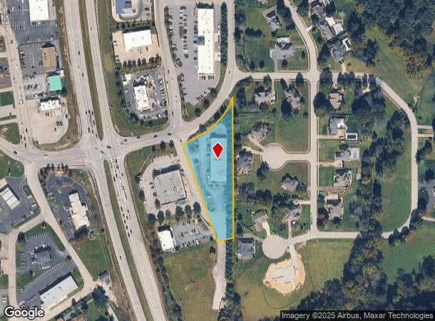
100 Lafollette Sta S
22-04-03-000-229.000-006
P 1198 L G 0-2-6 1.78 AC
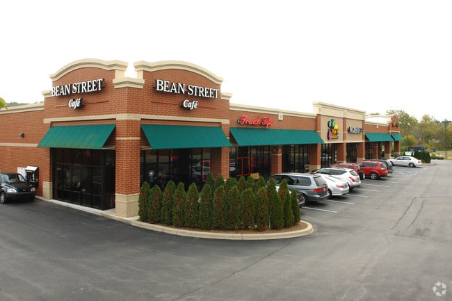
Stripcommercialcenter
FLOYD
B and X Area of moderate flood hazard, usually the area between the limits of the 100-year and 500-year floods.
Indiana
2025
1.78 AC
2025
Outlying Floyd County
071103
Louisville
11,520 SF
Louisville/Jefferson County, KY-IN
NEARBY LISTINGS FOR SALE OR LEASE
DEMOGRAPHICS near 100 Lafollette Sta S
1 mile
3 mile
5 mile
2025 Total Population
1,383
14,611
54,194
2030 Population
1,424
14,886
55,338
Pop Growth 2025-2030
+ 2.96%
+ 1.88%
+ 2.11%
Average Age
42
42
41
2025 Total Households
495
5,607
21,797
HH Growth 2025-2030
+ 2.83%
+ 1.82%
+ 2.13%
Median Household Inc
$128,420
$106,491
$75,110
Avg Household Size
2.80
2.60
2.40
2025 Avg HH Vehicles
3.00
2.00
2.00
Median Home Value
$363,194
$313,525
$254,873
Median Year Built
1991
1985
1974
Nearby Places
Map Layers
Map Styles
 Street
 Aerial
Transit
 Traffic
 Biking
Places
Listings with unknown addresses are not visible on the map
- Restaurants
- Banks
- Shops
- Fitness
- Groceries
PUBLIC TRANSPORTATION
AIRPORT
Louisville Muhammad Ali International
Drive
Walk
Distance
Louisville Muhammad Ali International
28 min
16.6 mi
Nearby Properties
Address
Land Use
TOTAL SIZE
Lot Size
Zoning
Address
Land Use
TOTAL SIZE
Lot Size
Zoning
39,851 SF
19.68 AC
Address
Land Use
TOTAL SIZE
Lot Size
Zoning
34,308 SF
4.59 AC
Address
Land Use
TOTAL SIZE
Lot Size
Zoning
118,371 SF
11.83 AC
Address
Land Use
TOTAL SIZE
Lot Size
Zoning
56,547 SF
5.65 AC
Address
Land Use
TOTAL SIZE
Lot Size
Zoning
26,864 SF
10.49 AC
Address
Land Use
TOTAL SIZE
Lot Size
Zoning
21,780 SF
11.44 AC
Address
Land Use
TOTAL SIZE
Lot Size
Zoning
29,470 SF
3.31 AC
Address
Land Use
TOTAL SIZE
Lot Size
Zoning
3,600 SF
7.90 AC
Address
Land Use
TOTAL SIZE
Lot Size
Zoning
45,194 SF
2.95 AC
Address
Land Use
TOTAL SIZE
Lot Size
Zoning
13,858 SF
11.28 AC
Address
Land Use
TOTAL SIZE
Lot Size
Zoning
112,628 SF
5.02 AC
Address
Land Use
TOTAL SIZE
Lot Size
Zoning
12,329 SF
7.60 AC
Address
Land Use
TOTAL SIZE
Lot Size
Zoning
12,630 SF
1.65 AC
Address
Land Use
TOTAL SIZE
Lot Size
Zoning
43,060 SF
1 AC
Address
Land Use
TOTAL SIZE
Lot Size
Zoning
15,000 SF
1.69 AC
Address
Land Use
TOTAL SIZE
Lot Size
Zoning
25,660 SF
2.20 AC
Address
Land Use
TOTAL SIZE
Lot Size
Zoning
16,128 SF
3.86 AC
Address
Land Use
TOTAL SIZE
Lot Size
Zoning
16,920 SF
1.38 AC
Address
Land Use
TOTAL SIZE
Lot Size
Zoning
26,320 SF
10.49 AC
Address
Land Use
TOTAL SIZE
Lot Size
Zoning
17,050 SF
5.46 AC
Address
Land Use
TOTAL SIZE
Lot Size
Zoning
39.70 AC
Address
Land Use
TOTAL SIZE
Lot Size
Zoning
8,640 SF
1.31 AC
Address
Land Use
TOTAL SIZE
Lot Size
Zoning
14,742 SF
1.30 AC
Address
Land Use
TOTAL SIZE
Lot Size
Zoning
20,250 SF
2.04 AC
Address
Land Use
TOTAL SIZE
Lot Size
Zoning
7,832 SF
4.76 AC
Address
Land Use
TOTAL SIZE
Lot Size
Zoning
Address
Land Use
TOTAL SIZE
Lot Size
Zoning
13,726 SF
3.32 AC
Address
Land Use
TOTAL SIZE
Lot Size
Zoning
16,960 SF
1.32 AC
Address
Land Use
TOTAL SIZE
Lot Size
Zoning
29,289 SF
1.71 AC
Address
Land Use
TOTAL SIZE
Lot Size
Zoning
840 SF
11.22 AC
The World's #1 Commercial Real Estate Marketplace
Connect with us
© 2026 CoStar Group
The information above has been obtained from sources believed reliable. While we do not doubt its accuracy we have not verified it and make no guarantee, warranty or representation about it. It is your responsibility to independently confirm its accuracy and completeness. Any projections, opinions, assumptions, or estimates used are for example only and do not represent the current or future performance of the property. The value of this transaction to you depends on tax and other factors which should be evaluated by your tax, financial, and legal advisors. You and your advisors should conduct a careful, independent investigation of the property to determine to your satisfaction the suitability of the property for your needs.