Property Record
100 Leroy Bowen Dr, Lynchburg, VA 24502

This Property Is For Sale
NEARBY LISTINGS FOR SALE OR LEASE
Property Detail
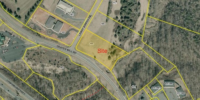
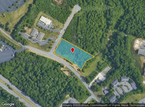
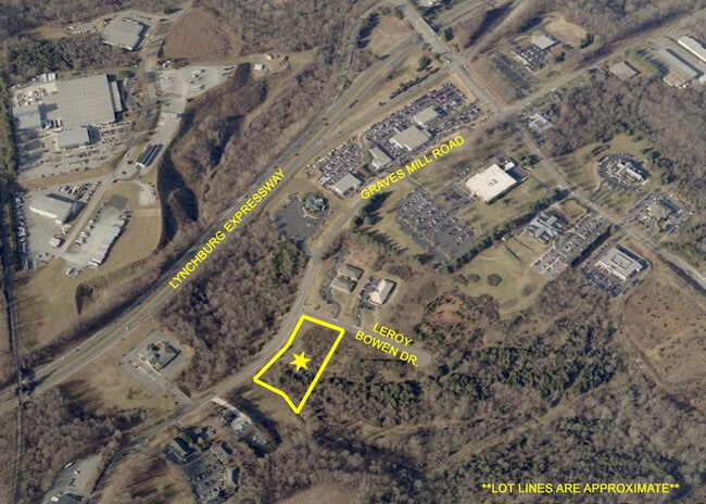
100 Leroy Bowen Dr
Lynchburg, VA
Graves Mill Commercial Corrido
238-14-007
LOT 7
Commercialacreage
Lynchburg City
AE
Virginia
51009C0390C
7
2025
2.18 AC
2025
Lynchburg
001602
Other Market Areas
DEMOGRAPHICS near 100 Leroy Bowen Dr
1 Mile
3 Mile
5 Mile
2024 Total Population
5,455
47,722
96,871
2029 Population
5,601
47,936
97,479
Pop Growth 2024-2029
+ 2.68%
+ 0.45%
+ 0.63%
Average Age
38
36
37
2024 Total Households
2,288
20,036
39,914
HH Growth 2024-2029
+ 2.75%
+ 0.44%
+ 0.62%
Median Household Inc
$57,823
$57,315
$58,143
Avg Household Size
2.20
2.20
2.30
2024 Avg HH Vehicles
2.00
2.00
2.00
Median Home Value
$160,141
$178,134
$194,099
Median Year Built
1978
1978
1975
Nearby Places
Map Layers
Map Styles
 Street
 Aerial
- Restaurants
- Banks
- Shops
- Fitness
- Groceries
PUBLIC TRANSPORTATION
COMMUTER RAIL
Lynchburg (Crescent - Amtrak, Northeast Regional - Amtrak)
DRIVE
WALK
Distance
Lynchburg (Crescent - Amtrak, Northeast Regional - Amtrak)
10 min
4.6 mi
AIRPORT
Lynchburg Regional/Preston Glenn Field
DRIVE
WALK
Distance
Lynchburg Regional/Preston Glenn Field
11 min
4.8 mi
Freight Ports
Virginia Port Authority - Richmond
DRIVE
WALK
Distance
Virginia Port Authority - Richmond
155 min
114.7 mi
Nearby Properties
Address
Land Use
TOTAL SIZE
Lot Size
Zoning
Address
Land Use
TOTAL SIZE
Lot Size
Zoning
1,116,411 SF
186.88 AC
B5
Address
Land Use
TOTAL SIZE
Lot Size
Zoning
816,228 SF
54.13 AC
B5I2
Address
Land Use
TOTAL SIZE
Lot Size
Zoning
814,428 SF
99.03 AC
212923
Address
Land Use
TOTAL SIZE
Lot Size
Zoning
3.33 AC
1909
Address
Land Use
TOTAL SIZE
Lot Size
Zoning
353,180 SF
22.86 AC
B3
Address
Land Use
TOTAL SIZE
Lot Size
Zoning
22.70 AC
Address
Land Use
TOTAL SIZE
Lot Size
Zoning
912 SF
52.88 AC
BGC
Address
Land Use
TOTAL SIZE
Lot Size
Zoning
400,209 SF
26.87 AC
B5
Address
Land Use
TOTAL SIZE
Lot Size
Zoning
326,293 SF
80.06 AC
R1R3
Address
Land Use
TOTAL SIZE
Lot Size
Zoning
1,282 SF
12.75 AC
Address
Land Use
TOTAL SIZE
Lot Size
Zoning
Address
Land Use
TOTAL SIZE
Lot Size
Zoning
1,200 SF
73.13 AC
Address
Land Use
TOTAL SIZE
Lot Size
Zoning
207,379 SF
10.24 AC
250905
Address
Land Use
TOTAL SIZE
Lot Size
Zoning
199,056 SF
16.21 AC
R1
Address
Land Use
TOTAL SIZE
Lot Size
Zoning
8,259 SF
13.02 AC
Address
Land Use
TOTAL SIZE
Lot Size
Zoning
181,808 SF
39.61 AC
192921
Address
Land Use
TOTAL SIZE
Lot Size
Zoning
221,676 SF
102.07 AC
231529
Address
Land Use
TOTAL SIZE
Lot Size
Zoning
387,080 SF
18.30 AC
1509
Address
Land Use
TOTAL SIZE
Lot Size
Zoning
Address
Land Use
TOTAL SIZE
Lot Size
Zoning
284,151 SF
70.13 AC
I3
Address
Land Use
TOTAL SIZE
Lot Size
Zoning
86,855 SF
10.68 AC
B1
Address
Land Use
TOTAL SIZE
Lot Size
Zoning
1,241 SF
7.20 AC
2519
Address
Land Use
TOTAL SIZE
Lot Size
Zoning
415,272 SF
117.43 AC
I3RC
Address
Land Use
TOTAL SIZE
Lot Size
Zoning
155,125 SF
38.67 AC
250129
Address
Land Use
TOTAL SIZE
Lot Size
Zoning
267,447 SF
28.46 AC
B3
Address
Land Use
TOTAL SIZE
Lot Size
Zoning
161,688 SF
16.57 AC
R3RC
Address
Land Use
TOTAL SIZE
Lot Size
Zoning
222,427 SF
23.56 AC
I2RC
Address
Land Use
TOTAL SIZE
Lot Size
Zoning
103,515 SF
25.04 AC
B5R1
Address
Land Use
TOTAL SIZE
Lot Size
Zoning
1,120 SF
16.81 AC
RMF
Address
Land Use
TOTAL SIZE
Lot Size
Zoning
3,478 SF
13.10 AC
RMFC
The World's #1 Commercial Real Estate Marketplace
Connect with us
© 2026 CoStar Group
The information above has been obtained from sources believed reliable. While we do not doubt its accuracy we have not verified it and make no guarantee, warranty or representation about it. It is your responsibility to independently confirm its accuracy and completeness. Any projections, opinions, assumptions, or estimates used are for example only and do not represent the current or future performance of the property. The value of this transaction to you depends on tax and other factors which should be evaluated by your tax, financial, and legal advisors. You and your advisors should conduct a careful, independent investigation of the property to determine to your satisfaction the suitability of the property for your needs.