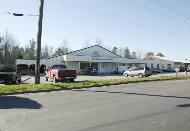
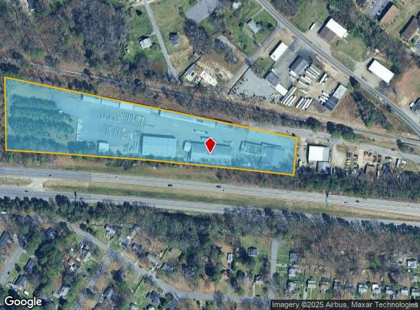
Property Record
100 Lumber Dr, Sandston, VA 23150
NEARBY LISTINGS FOR SALE OR LEASE
Property Detail
100 Lumber Dr
826-718-1879
Sandston
Publicstorage
0156030020 0014; SANDSTON SC C BL 20 AC 7.228 NL RT 64 11 B2 8
X
Henrico
51087C0164D
Virginia
2025
7.23 AC
2025
Airport
201205
Richmond VA
13,190 SF
Richmond, VA
DEMOGRAPHICS near 100 Lumber Dr
1 Mile
3 Mile
5 Mile
2024 Total Population
7,100
30,120
77,243
2029 Population
7,063
29,931
77,983
Pop Growth 2024-2029
(0.52%)
(0.63%)
+ 0.96%
Average Age
39
40
40
2024 Total Households
2,813
12,213
31,271
HH Growth 2024-2029
(0.57%)
(0.64%)
+ 0.95%
Median Household Inc
$55,939
$54,656
$56,053
Avg Household Size
2.50
2.40
2.40
2024 Avg HH Vehicles
2.00
2.00
2.00
Median Home Value
$169,399
$166,138
$196,778
Median Year Built
1976
1977
1980
Nearby Places
Map Layers
Map Styles
 Street
 Aerial
- Restaurants
- Banks
- Shops
- Fitness
- Groceries
PUBLIC TRANSPORTATION
COMMUTER RAIL
DRIVE
WALK
Distance
14 min
8.4 mi
AIRPORT
Richmond International
DRIVE
WALK
Distance
Richmond International
7 min
2.6 mi
Freight Ports
Virginia Port Authority - Richmond
DRIVE
WALK
Distance
Virginia Port Authority - Richmond
24 min
13.6 mi
Nearby Properties
Address
Land Use
TOTAL SIZE
Lot Size
Zoning
Address
Land Use
TOTAL SIZE
Lot Size
Zoning
548,680 SF
2,298.89 AC
MIXE
Address
Land Use
TOTAL SIZE
Lot Size
Zoning
143,287 SF
56.39 AC
MIXE
Address
Land Use
TOTAL SIZE
Lot Size
Zoning
60,032 SF
62 AC
B-3C
Address
Land Use
TOTAL SIZE
Lot Size
Zoning
49,152 SF
31.21 AC
M-1
Address
Land Use
TOTAL SIZE
Lot Size
Zoning
522,399 SF
58.07 AC
M-1
Address
Land Use
TOTAL SIZE
Lot Size
Zoning
186,390 SF
13.50 AC
R-5
Address
Land Use
TOTAL SIZE
Lot Size
Zoning
444,069 SF
23.82 AC
M-1
Address
Land Use
TOTAL SIZE
Lot Size
Zoning
173,637 SF
15.48 AC
R-5
Address
Land Use
TOTAL SIZE
Lot Size
Zoning
322,000 SF
15.94 AC
M-1
Address
Land Use
TOTAL SIZE
Lot Size
Zoning
181,200 SF
14.74 AC
R-5
Address
Land Use
TOTAL SIZE
Lot Size
Zoning
146,560 SF
11.09 AC
R-5
Address
Land Use
TOTAL SIZE
Lot Size
Zoning
15,680 SF
39.75 AC
R-3
Address
Land Use
TOTAL SIZE
Lot Size
Zoning
8,440 SF
8.27 AC
R-6
Address
Land Use
TOTAL SIZE
Lot Size
Zoning
179,359 SF
11.85 AC
M-1
Address
Land Use
TOTAL SIZE
Lot Size
Zoning
190,138 SF
16.99 AC
MIXE
Address
Land Use
TOTAL SIZE
Lot Size
Zoning
108,738 SF
6.39 AC
R-6
Address
Land Use
TOTAL SIZE
Lot Size
Zoning
142,379 SF
17.69 AC
M-1
Address
Land Use
TOTAL SIZE
Lot Size
Zoning
95,288 SF
9.94 AC
MIXE
Address
Land Use
TOTAL SIZE
Lot Size
Zoning
143,332 SF
6.12 AC
M-1C
Address
Land Use
TOTAL SIZE
Lot Size
Zoning
137,051 SF
16.39 AC
B-3C
Address
Land Use
TOTAL SIZE
Lot Size
Zoning
69,248 SF
5.24 AC
B-3C
Address
Land Use
TOTAL SIZE
Lot Size
Zoning
53,530 SF
4.50 AC
M-1C
Address
Land Use
TOTAL SIZE
Lot Size
Zoning
144,135 SF
9.72 AC
M-1
Address
Land Use
TOTAL SIZE
Lot Size
Zoning
127,868 SF
12.85 AC
B-3C
Address
Land Use
TOTAL SIZE
Lot Size
Zoning
9.66 AC
R-5
Address
Land Use
TOTAL SIZE
Lot Size
Zoning
156,390 SF
13.37 AC
B-3C
Address
Land Use
TOTAL SIZE
Lot Size
Zoning
316,548 SF
20.94 AC
M-1
Address
Land Use
TOTAL SIZE
Lot Size
Zoning
134,944 SF
8.83 AC
R-5
Address
Land Use
TOTAL SIZE
Lot Size
Zoning
63,700 SF
19.50 AC
A-1
Address
Land Use
TOTAL SIZE
Lot Size
Zoning
130,638 SF
11.06 AC
R-5
The World's #1 Commercial Real Estate Marketplace
Connect with us
© 2026 CoStar Group
The information above has been obtained from sources believed reliable. While we do not doubt its accuracy we have not verified it and make no guarantee, warranty or representation about it. It is your responsibility to independently confirm its accuracy and completeness. Any projections, opinions, assumptions, or estimates used are for example only and do not represent the current or future performance of the property. The value of this transaction to you depends on tax and other factors which should be evaluated by your tax, financial, and legal advisors. You and your advisors should conduct a careful, independent investigation of the property to determine to your satisfaction the suitability of the property for your needs.