Property Record
100 Maple Park Blvd, Saint Clair Shores, MI 48081

NEARBY LISTINGS FOR SALE OR LEASE
Property Detail
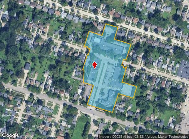
100 Maple Park Blvd
Detroit-Warren-Dearborn, MI
Maple Park Subdivision
09-14-27-201-025
MAPLE PARK SUBDIVISION (L7, P22) LOTS 17-23, LOT 24 EXC THE S 13.5' OF THE W 22', ALL OF LOTS 108-114, LOT 115 EXC THE N
Officebuilding
Macomb
X
Michigan
26163C0135F
17-23,1
2025
5.61 AC
2025
Macomb East
251200
Detroit
62,619 SF
DEMOGRAPHICS near 100 Maple Park Blvd
1 Mile
3 Mile
5 Mile
2024 Total Population
12,663
95,650
234,803
2029 Population
12,467
93,854
230,797
Pop Growth 2024-2029
(1.55%)
(1.88%)
(1.71%)
Average Age
45
42
40
2024 Total Households
5,911
41,255
96,390
HH Growth 2024-2029
(1.61%)
(1.94%)
(1.76%)
Median Household Inc
$72,327
$64,947
$60,230
Avg Household Size
2.10
2.30
2.40
2024 Avg HH Vehicles
2.00
2.00
2.00
Median Home Value
$178,672
$160,511
$150,339
Median Year Built
1956
1956
1956
Nearby Places
Map Layers
Map Styles
 Street
 Aerial
- Restaurants
- Banks
- Shops
- Fitness
- Groceries
PUBLIC TRANSPORTATION
AIRPORT
Windsor International
DRIVE
WALK
Distance
Windsor International
48 min
25.0 mi
Detroit Metro Wayne County
DRIVE
WALK
Distance
Detroit Metro Wayne County
52 min
34.5 mi
SALE & LEASE HISTORY
LISTING DATE
SALE/LEASE

Sep 25, 2016
For Lease
Apr 13, 2021
For Sale
Apr 13, 2021
For Lease
Nearby Properties
Address
Land Use
TOTAL SIZE
Lot Size
Zoning
Address
Land Use
TOTAL SIZE
Lot Size
Zoning
9,937 SF
35.42 AC
CLD
Address
Land Use
TOTAL SIZE
Lot Size
Zoning
153,882 SF
5.65 AC
RA
Address
Land Use
TOTAL SIZE
Lot Size
Zoning
89,970 SF
2.86 AC
RM-1
Address
Land Use
TOTAL SIZE
Lot Size
Zoning
192,387 SF
11.26 AC
CLD
Address
Land Use
TOTAL SIZE
Lot Size
Zoning
129,502 SF
3.17 AC
RM-1
Address
Land Use
TOTAL SIZE
Lot Size
Zoning
179,653 SF
11.56 AC
B-2
Address
Land Use
TOTAL SIZE
Lot Size
Zoning
103,069 SF
11.41 AC
B-3
Address
Land Use
TOTAL SIZE
Lot Size
Zoning
115,307 SF
7.01 AC
RM-1
Address
Land Use
TOTAL SIZE
Lot Size
Zoning
178,358 SF
12.41 AC
B-2
Address
Land Use
TOTAL SIZE
Lot Size
Zoning
75,284 SF
0.87 AC
C
Address
Land Use
TOTAL SIZE
Lot Size
Zoning
167,589 SF
16.80 AC
B-3
Address
Land Use
TOTAL SIZE
Lot Size
Zoning
202,788 SF
27.98 AC
CLD
Address
Land Use
TOTAL SIZE
Lot Size
Zoning
119,898 SF
14.65 AC
B-2
Address
Land Use
TOTAL SIZE
Lot Size
Zoning
133,611 SF
11.74 AC
B-3
Address
Land Use
TOTAL SIZE
Lot Size
Zoning
5,511 SF
1.52 AC
Address
Land Use
TOTAL SIZE
Lot Size
Zoning
136,270 SF
3.42 AC
LI
Address
Land Use
TOTAL SIZE
Lot Size
Zoning
143,568 SF
6.41 AC
B-2
Address
Land Use
TOTAL SIZE
Lot Size
Zoning
91,739 SF
6.54 AC
B-2
Address
Land Use
TOTAL SIZE
Lot Size
Zoning
30,244 SF
2.06 AC
B-1
Address
Land Use
TOTAL SIZE
Lot Size
Zoning
28,300 SF
11.49 AC
I-1
Address
Land Use
TOTAL SIZE
Lot Size
Zoning
44,450 SF
3.80 AC
O-1
Address
Land Use
TOTAL SIZE
Lot Size
Zoning
11,315 SF
41.52 AC
RA
Address
Land Use
TOTAL SIZE
Lot Size
Zoning
7,797 SF
24.23 AC
CLD
Address
Land Use
TOTAL SIZE
Lot Size
Zoning
46,246 SF
3.19 AC
B-3
Address
Land Use
TOTAL SIZE
Lot Size
Zoning
71,025 SF
4.03 AC
RM-1
Address
Land Use
TOTAL SIZE
Lot Size
Zoning
30,919 SF
0.86 AC
C
Address
Land Use
TOTAL SIZE
Lot Size
Zoning
92,903 SF
1.70 AC
LI
Address
Land Use
TOTAL SIZE
Lot Size
Zoning
80,320 SF
4.73 AC
RM-1
Address
Land Use
TOTAL SIZE
Lot Size
Zoning
107,519 SF
7.02 AC
RM-1
Address
Land Use
TOTAL SIZE
Lot Size
Zoning
36,191 SF
3.87 AC
B-2
The World's #1 Commercial Real Estate Marketplace
Connect with us
© 2026 CoStar Group
The information above has been obtained from sources believed reliable. While we do not doubt its accuracy we have not verified it and make no guarantee, warranty or representation about it. It is your responsibility to independently confirm its accuracy and completeness. Any projections, opinions, assumptions, or estimates used are for example only and do not represent the current or future performance of the property. The value of this transaction to you depends on tax and other factors which should be evaluated by your tax, financial, and legal advisors. You and your advisors should conduct a careful, independent investigation of the property to determine to your satisfaction the suitability of the property for your needs.