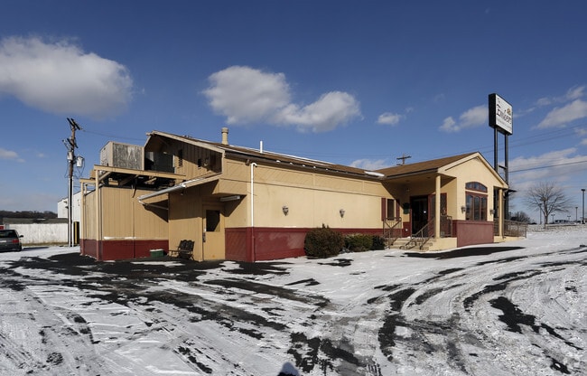
Property Record
100 Memory Ln, York, PA 17402


Property Detail
100 Memory Ln
Restaurantbuilding
York
MU
Pennsylvania
B and X Area of moderate flood hazard, usually the area between the limits of the 100-year and 500-year floods.
0.87 AC
2025
York County
2025
Philadelphia
010210
York-Hanover, PA
4,133 SF
46-000-02-0035.A0-00000
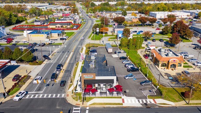
NEARBY LISTINGS FOR SALE OR LEASE
DEMOGRAPHICS near 100 Memory Ln
1 mile
3 mile
5 mile
2025 Total Population
7,177
74,887
147,330
2030 Population
7,416
77,052
151,436
Pop Growth 2025-2030
+ 3.33%
+ 2.89%
+ 2.79%
Average Age
42
40
40
2025 Total Households
2,812
29,330
56,938
HH Growth 2025-2030
+ 3.63%
+ 3.03%
+ 2.91%
Median Household Inc
$76,177
$68,068
$71,964
Avg Household Size
2.40
2.40
2.40
2025 Avg HH Vehicles
2.00
2.00
2.00
Median Home Value
$228,234
$236,374
$235,494
Median Year Built
1957
1961
1963
Nearby Places
Map Layers
Map Styles
 Street
 Aerial
Layers
 Traffic
 Biking
Places
Listings with unknown addresses are not visible on the map
- Restaurants
- Banks
- Shops
- Fitness
- Groceries
PUBLIC TRANSPORTATION
AIRPORT
Harrisburg International
Drive
Walk
Distance
Harrisburg International
43 min
31.0 mi
Freight Ports
Port of Baltimore
Drive
Walk
Distance
Port of Baltimore
72 min
53.9 mi
SALE & LEASE HISTORY
LISTING DATE
SALE/LEASE

Oct 25, 2023
For Lease
Oct 05, 2023
For Sale
May 11, 2017
For Lease
May 11, 2017
For Sale
Jan 09, 2018
For Lease
Feb 12, 2020
For Sale
Dec 13, 2016
For Lease
Dec 08, 2016
For Sale
Aug 07, 2017
For Sale
Nearby Properties
Address
Land Use
TOTAL SIZE
Lot Size
Zoning
Address
Land Use
TOTAL SIZE
Lot Size
Zoning
21 AC
I
Address
Land Use
TOTAL SIZE
Lot Size
Zoning
779,291 SF
95.61 AC
I
Address
Land Use
TOTAL SIZE
Lot Size
Zoning
1,068,680 SF
64.22 AC
I
Address
Land Use
TOTAL SIZE
Lot Size
Zoning
754,640 SF
54.36 AC
Address
Land Use
TOTAL SIZE
Lot Size
Zoning
123,796 SF
26.99 AC
CH
Address
Land Use
TOTAL SIZE
Lot Size
Zoning
398,644 SF
50.92 AC
CH
Address
Land Use
TOTAL SIZE
Lot Size
Zoning
271,039 SF
47.69 AC
CH
Address
Land Use
TOTAL SIZE
Lot Size
Zoning
286,411 SF
35.12 AC
CM
Address
Land Use
TOTAL SIZE
Lot Size
Zoning
12.15 AC
Address
Land Use
TOTAL SIZE
Lot Size
Zoning
1,882 SF
16.46 AC
RS
Address
Land Use
TOTAL SIZE
Lot Size
Zoning
150,082 SF
3.45 AC
Address
Land Use
TOTAL SIZE
Lot Size
Zoning
170,850 SF
27.83 AC
FD
Address
Land Use
TOTAL SIZE
Lot Size
Zoning
195,669 SF
22.25 AC
RS
Address
Land Use
TOTAL SIZE
Lot Size
Zoning
28.77 AC
I
Address
Land Use
TOTAL SIZE
Lot Size
Zoning
12,432 SF
27.56 AC
R1
Address
Land Use
TOTAL SIZE
Lot Size
Zoning
42,414 SF
25.52 AC
ID
Address
Land Use
TOTAL SIZE
Lot Size
Zoning
7.08 AC
FD
Address
Land Use
TOTAL SIZE
Lot Size
Zoning
373,298 SF
24.99 AC
GI
Address
Land Use
TOTAL SIZE
Lot Size
Zoning
40.04 AC
AG
Address
Land Use
TOTAL SIZE
Lot Size
Zoning
483,676 SF
165.85 AC
I
Address
Land Use
TOTAL SIZE
Lot Size
Zoning
47,648 SF
25.99 AC
MU
Address
Land Use
TOTAL SIZE
Lot Size
Zoning
247,968 SF
22.27 AC
RS
Address
Land Use
TOTAL SIZE
Lot Size
Zoning
9,000 SF
10.80 AC
BI
Address
Land Use
TOTAL SIZE
Lot Size
Zoning
53,226 SF
18.19 AC
ID
Address
Land Use
TOTAL SIZE
Lot Size
Zoning
379,696 SF
20.09 AC
GI
Address
Land Use
TOTAL SIZE
Lot Size
Zoning
101,698 SF
5.88 AC
BI
Address
Land Use
TOTAL SIZE
Lot Size
Zoning
408,240 SF
14.60 AC
FD
Address
Land Use
TOTAL SIZE
Lot Size
Zoning
57,358 SF
9 AC
NC
Address
Land Use
TOTAL SIZE
Lot Size
Zoning
27,324 SF
12.67 AC
RH9
Address
Land Use
TOTAL SIZE
Lot Size
Zoning
111,200 SF
17.06 AC
R1
The World's #1 Commercial Real Estate Marketplace
Connect with us
© 2026 CoStar Group
The information above has been obtained from sources believed reliable. While we do not doubt its accuracy we have not verified it and make no guarantee, warranty or representation about it. It is your responsibility to independently confirm its accuracy and completeness. Any projections, opinions, assumptions, or estimates used are for example only and do not represent the current or future performance of the property. The value of this transaction to you depends on tax and other factors which should be evaluated by your tax, financial, and legal advisors. You and your advisors should conduct a careful, independent investigation of the property to determine to your satisfaction the suitability of the property for your needs.