Property Record
100 Mountain Rd, Easthampton, MA 01027
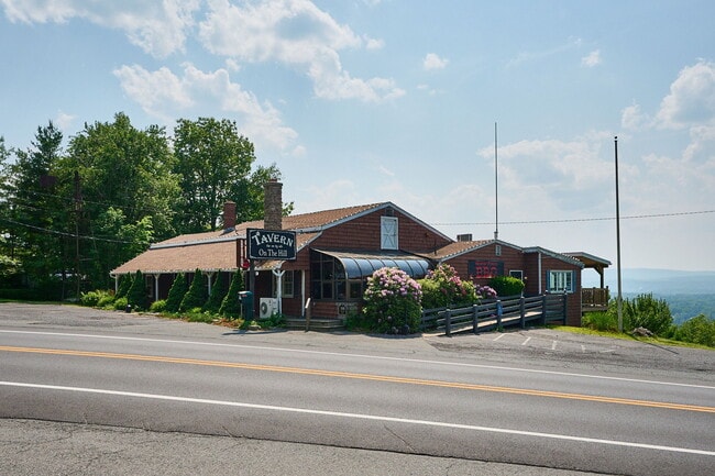


This Property Is For Sale
Property Detail
100 Mountain Rd
EHAM-000176-000001
HAMPSHIRE
Restaurantbuilding
Massachusetts
R80
1.55 AC
2025
Hampshire County
2025
Hartford
822401
Amherst Town-Northampton, MA
3,609 SF
NEARBY LISTINGS FOR SALE OR LEASE
DEMOGRAPHICS near 100 Mountain Rd
1 mile
3 mile
5 mile
2025 Total Population
779
36,573
93,175
2030 Population
774
36,500
93,053
Pop Growth 2025-2030
(0.64%)
(0.20%)
(0.13%)
Average Age
47
43
42
2025 Total Households
321
15,898
38,395
HH Growth 2025-2030
(0.62%)
(0.16%)
(0.11%)
Median Household Inc
$93,589
$65,596
$66,160
Avg Household Size
2.40
2.20
2.30
2025 Avg HH Vehicles
2.00
2.00
2.00
Median Home Value
$384,736
$332,313
$325,512
Median Year Built
1975
1954
1956
Nearby Places
Map Layers
Map Styles
 Street
 Aerial
Transit
 Traffic
 Biking
Places
Listings with unknown addresses are not visible on the map
- Restaurants
- Banks
- Shops
- Fitness
- Groceries
PUBLIC TRANSPORTATION
COMMUTER RAIL
Holyoke Amtrak (Valley Flyer - Amtrak, Vermonter - Amtrak)
Drive
Walk
Distance
Holyoke Amtrak (Valley Flyer - Amtrak, Vermonter - Amtrak)
8 min
4.0 mi
Northampton (Valley Flyer - Amtrak, Vermonter - Amtrak)
Drive
Walk
Distance
Northampton (Valley Flyer - Amtrak, Vermonter - Amtrak)
13 min
7.3 mi
AIRPORT
Bradley International
Drive
Walk
Distance
Bradley International
45 min
23.4 mi
Freight Ports
Albany, NY Port
Drive
Walk
Distance
Albany, NY Port
105 min
85.4 mi
Nearby Properties
Address
Land Use
TOTAL SIZE
Lot Size
Zoning
Address
Land Use
TOTAL SIZE
Lot Size
Zoning
22.15 AC
R-1A
Address
Land Use
TOTAL SIZE
Lot Size
Zoning
42,416 SF
17.58 AC
R10
Address
Land Use
TOTAL SIZE
Lot Size
Zoning
17.72 AC
R-2
Address
Land Use
TOTAL SIZE
Lot Size
Zoning
126,515 SF
183.24 AC
R40
Address
Land Use
TOTAL SIZE
Lot Size
Zoning
5,272 SF
16.12 AC
R10
Address
Land Use
TOTAL SIZE
Lot Size
Zoning
115,407 SF
7.53 AC
R10
Address
Land Use
TOTAL SIZE
Lot Size
Zoning
196,705 SF
21.45 AC
RM20
Address
Land Use
TOTAL SIZE
Lot Size
Zoning
201,410 SF
13.16 AC
RM20
Address
Land Use
TOTAL SIZE
Lot Size
Zoning
62,808 SF
7.60 AC
R-1
Address
Land Use
TOTAL SIZE
Lot Size
Zoning
161,190 SF
17.15 AC
RM20
Address
Land Use
TOTAL SIZE
Lot Size
Zoning
48,626 SF
4.25 AC
DB
Address
Land Use
TOTAL SIZE
Lot Size
Zoning
77,702 SF
16.39 AC
RM20
Address
Land Use
TOTAL SIZE
Lot Size
Zoning
812,675 SF
19.64 AC
BH
Address
Land Use
TOTAL SIZE
Lot Size
Zoning
17.68 AC
IGD
Address
Land Use
TOTAL SIZE
Lot Size
Zoning
7.60 AC
BG
Address
Land Use
TOTAL SIZE
Lot Size
Zoning
15,248 SF
15.40 AC
AGR
Address
Land Use
TOTAL SIZE
Lot Size
Zoning
4.88 AC
RM20
Address
Land Use
TOTAL SIZE
Lot Size
Zoning
14.80 AC
Address
Land Use
TOTAL SIZE
Lot Size
Zoning
1,280.42 AC
RA
Address
Land Use
TOTAL SIZE
Lot Size
Zoning
480,770 SF
6.98 AC
MI
Address
Land Use
TOTAL SIZE
Lot Size
Zoning
3,792 SF
7.27 AC
R15
Address
Land Use
TOTAL SIZE
Lot Size
Zoning
27,040 SF
14.60 AC
I
Address
Land Use
TOTAL SIZE
Lot Size
Zoning
81,022 SF
2.20 AC
RM60
Address
Land Use
TOTAL SIZE
Lot Size
Zoning
22,874 SF
2.39 AC
DR
Address
Land Use
TOTAL SIZE
Lot Size
Zoning
90,748 SF
MI
Address
Land Use
TOTAL SIZE
Lot Size
Zoning
43,286 SF
0.71 AC
R5
Address
Land Use
TOTAL SIZE
Lot Size
Zoning
10.50 AC
RA2
Address
Land Use
TOTAL SIZE
Lot Size
Zoning
20.40 AC
RM20
Address
Land Use
TOTAL SIZE
Lot Size
Zoning
4,180 SF
3.50 AC
RA1
Address
Land Use
TOTAL SIZE
Lot Size
Zoning
22,484 SF
9.72 AC
I
The World's #1 Commercial Real Estate Marketplace
Connect with us
© 2026 CoStar Group
The information above has been obtained from sources believed reliable. While we do not doubt its accuracy we have not verified it and make no guarantee, warranty or representation about it. It is your responsibility to independently confirm its accuracy and completeness. Any projections, opinions, assumptions, or estimates used are for example only and do not represent the current or future performance of the property. The value of this transaction to you depends on tax and other factors which should be evaluated by your tax, financial, and legal advisors. You and your advisors should conduct a careful, independent investigation of the property to determine to your satisfaction the suitability of the property for your needs.