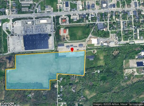
Property Record
100 S Muessing St, Indianapolis, IN 46229
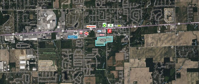
NEARBY LISTINGS FOR SALE OR LEASE
Property Detail
100 S Muessing St
49-09-03-114-005.000-700
W1/2 Sw1/4 & Sw1/4 Se1/4 S3 T15 R5
Farms
W1/2 SW1/4 & SW1/4 SE1/4 S3 T15 R5 BEG 1115.47 N& 1572.76 E OF SW COR S 350 W 250 S 511.61 E1127.43 N 240.84 E 193.81 N 125 SE 695.92N654.99 W 1555.76 TO BEG 34.296AC
X
Marion
18097C0190F
Indiana
2023
34.30 AC
2024
Lawrence/East County
360501
Indianapolis
76,784 SF
Indianapolis-Carmel-Anderson, IN
DEMOGRAPHICS near 100 S Muessing St
1 Mile
3 Mile
5 Mile
2024 Total Population
6,433
41,366
111,837
2029 Population
6,498
41,610
112,577
Pop Growth 2024-2029
+ 1.01%
+ 0.59%
+ 0.66%
Average Age
38
39
37
2024 Total Households
2,437
15,583
41,653
HH Growth 2024-2029
+ 1.07%
+ 0.55%
+ 0.65%
Median Household Inc
$84,712
$76,456
$62,417
Avg Household Size
2.60
2.60
2.60
2024 Avg HH Vehicles
2.00
2.00
2.00
Median Home Value
$177,984
$188,719
$181,933
Median Year Built
1992
1986
1978
Nearby Places
Map Layers
Map Styles
 Street
 Aerial
- Restaurants
- Banks
- Shops
- Fitness
- Groceries
PUBLIC TRANSPORTATION
AIRPORT
Indianapolis International
DRIVE
WALK
Distance
Indianapolis International
45 min
25.6 mi
Freight Ports
Port of Toledo
DRIVE
WALK
Distance
Port of Toledo
268 min
219.0 mi
SALE & LEASE HISTORY
LISTING DATE
SALE/LEASE

Dec 10, 2024
For Lease
Nearby Properties
Address
Land Use
TOTAL SIZE
Lot Size
Zoning
Address
Land Use
TOTAL SIZE
Lot Size
Zoning
4,379 SF
11.48 AC
ZO01
Address
Land Use
TOTAL SIZE
Lot Size
Zoning
5,620 SF
36.95 AC
ZO01
Address
Land Use
TOTAL SIZE
Lot Size
Zoning
76,663 SF
1.91 AC
ZO01
Address
Land Use
TOTAL SIZE
Lot Size
Zoning
213,102 SF
14.51 AC
Address
Land Use
TOTAL SIZE
Lot Size
Zoning
234,064 SF
29.49 AC
ZO01
Address
Land Use
TOTAL SIZE
Lot Size
Zoning
198,375 SF
24.52 AC
ZO01
Address
Land Use
TOTAL SIZE
Lot Size
Zoning
2,730 SF
21.24 AC
Address
Land Use
TOTAL SIZE
Lot Size
Zoning
5,560 SF
10.88 AC
ZO01
Address
Land Use
TOTAL SIZE
Lot Size
Zoning
170,000 SF
11.29 AC
ZO01
Address
Land Use
TOTAL SIZE
Lot Size
Zoning
169,094 SF
10.43 AC
ZO01
Address
Land Use
TOTAL SIZE
Lot Size
Zoning
4,202 SF
19.62 AC
Address
Land Use
TOTAL SIZE
Lot Size
Zoning
140,976 SF
15.46 AC
ZO01
Address
Land Use
TOTAL SIZE
Lot Size
Zoning
51,390 SF
40.43 AC
Address
Land Use
TOTAL SIZE
Lot Size
Zoning
76,456 SF
24.91 AC
Address
Land Use
TOTAL SIZE
Lot Size
Zoning
48,838 SF
15.09 AC
Address
Land Use
TOTAL SIZE
Lot Size
Zoning
5,070 SF
13.62 AC
ZO01
Address
Land Use
TOTAL SIZE
Lot Size
Zoning
113,863 SF
13.60 AC
Address
Land Use
TOTAL SIZE
Lot Size
Zoning
2,669 SF
16.29 AC
ZO01
Address
Land Use
TOTAL SIZE
Lot Size
Zoning
15,008 SF
18.12 AC
ZO01
Address
Land Use
TOTAL SIZE
Lot Size
Zoning
13,712 SF
26.10 AC
ZO01
Address
Land Use
TOTAL SIZE
Lot Size
Zoning
107,656 SF
7.66 AC
Address
Land Use
TOTAL SIZE
Lot Size
Zoning
160,410 SF
13.71 AC
Address
Land Use
TOTAL SIZE
Lot Size
Zoning
12,786 SF
24.78 AC
ZO01
Address
Land Use
TOTAL SIZE
Lot Size
Zoning
121,697 SF
10.05 AC
ZO01
Address
Land Use
TOTAL SIZE
Lot Size
Zoning
2,784 SF
23 AC
ZO01
Address
Land Use
TOTAL SIZE
Lot Size
Zoning
5,287 SF
16.61 AC
ZO01
Address
Land Use
TOTAL SIZE
Lot Size
Zoning
37,364 SF
10 AC
ZO01
Address
Land Use
TOTAL SIZE
Lot Size
Zoning
54,354 SF
5.11 AC
ZO01
Address
Land Use
TOTAL SIZE
Lot Size
Zoning
86,932 SF
9.99 AC
Address
Land Use
TOTAL SIZE
Lot Size
Zoning
27,895 SF
5.07 AC
The World's #1 Commercial Real Estate Marketplace
Connect with us
© 2025 CoStar Group
The information above has been obtained from sources believed reliable. While we do not doubt its accuracy we have not verified it and make no guarantee, warranty or representation about it. It is your responsibility to independently confirm its accuracy and completeness. Any projections, opinions, assumptions, or estimates used are for example only and do not represent the current or future performance of the property. The value of this transaction to you depends on tax and other factors which should be evaluated by your tax, financial, and legal advisors. You and your advisors should conduct a careful, independent investigation of the property to determine to your satisfaction the suitability of the property for your needs.