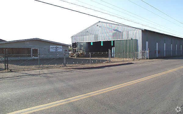
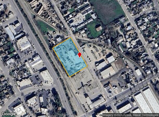
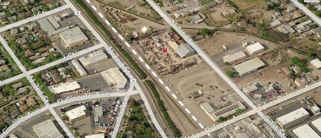
Property Record
100 N 1St St, Patterson, CA 95363

NEARBY LISTINGS FOR SALE OR LEASE
Property Detail
100 N 1St St
Modesto, CA
Patterson
131-02-03
PATTERSON LOT 1-6 BLOCK 36
Industrialgeneral
Stanislaus
X
California
06099C0732E
t
2025
2.30 AC
2025
Patterson
003201
Stockton/Modesto
12,328 SF
DEMOGRAPHICS near 100 N 1St St
1 Mile
3 Mile
5 Mile
2024 Total Population
12,908
25,888
26,699
2029 Population
12,986
25,941
26,734
Pop Growth 2024-2029
+ 0.60%
+ 0.20%
+ 0.13%
Average Age
35
35
35
2024 Total Households
3,674
7,065
7,315
HH Growth 2024-2029
+ 0.52%
+ 0.14%
+ 0.05%
Median Household Inc
$74,578
$89,631
$89,817
Avg Household Size
3.50
3.60
3.60
2024 Avg HH Vehicles
2.00
2.00
3.00
Median Home Value
$357,214
$411,849
$415,867
Median Year Built
1987
1999
1998
Nearby Places
Map Layers
Map Styles
 Street
 Aerial
- Restaurants
- Banks
- Shops
- Fitness
- Groceries
PUBLIC TRANSPORTATION
AIRPORT
Stockton Metro
DRIVE
WALK
Distance
Stockton Metro
49 min
40.3 mi
Freight Ports
Port of Stockton
DRIVE
WALK
Distance
Port of Stockton
52 min
43.8 mi
SALE & LEASE HISTORY
LISTING DATE
SALE/LEASE

Sep 23, 2016
For Sale
Nearby Properties
Address
Land Use
TOTAL SIZE
Lot Size
Zoning
Address
Land Use
TOTAL SIZE
Lot Size
Zoning
1,481,142 SF
93.66 AC
Address
Land Use
TOTAL SIZE
Lot Size
Zoning
800,358 SF
45.99 AC
Address
Land Use
TOTAL SIZE
Lot Size
Zoning
809,971 SF
51.30 AC
0
Address
Land Use
TOTAL SIZE
Lot Size
Zoning
712,101 SF
34.57 AC
PATHI
Address
Land Use
TOTAL SIZE
Lot Size
Zoning
44.79 AC
PATLI
Address
Land Use
TOTAL SIZE
Lot Size
Zoning
1,015,740 SF
33.78 AC
PD
Address
Land Use
TOTAL SIZE
Lot Size
Zoning
396,402 SF
62.64 AC
PATLI
Address
Land Use
TOTAL SIZE
Lot Size
Zoning
21.22 AC
PD
Address
Land Use
TOTAL SIZE
Lot Size
Zoning
529,970 SF
28.41 AC
PATLI
Address
Land Use
TOTAL SIZE
Lot Size
Zoning
23,986 SF
14.29 AC
PATHSC
Address
Land Use
TOTAL SIZE
Lot Size
Zoning
151,117 SF
14.82 AC
PC
Address
Land Use
TOTAL SIZE
Lot Size
Zoning
59.88 AC
Address
Land Use
TOTAL SIZE
Lot Size
Zoning
14,636 SF
11.30 AC
PATLI
Address
Land Use
TOTAL SIZE
Lot Size
Zoning
98,820 SF
5.23 AC
Address
Land Use
TOTAL SIZE
Lot Size
Zoning
36.70 AC
Address
Land Use
TOTAL SIZE
Lot Size
Zoning
50,161 SF
2.95 AC
PD
Address
Land Use
TOTAL SIZE
Lot Size
Zoning
50,889 SF
4.02 AC
Address
Land Use
TOTAL SIZE
Lot Size
Zoning
49,265 SF
2.65 AC
Address
Land Use
TOTAL SIZE
Lot Size
Zoning
43,160 SF
4.29 AC
Address
Land Use
TOTAL SIZE
Lot Size
Zoning
18.88 AC
A220
Address
Land Use
TOTAL SIZE
Lot Size
Zoning
6,851 SF
1.17 AC
PD
Address
Land Use
TOTAL SIZE
Lot Size
Zoning
15,690 SF
2.25 AC
Address
Land Use
TOTAL SIZE
Lot Size
Zoning
3.93 AC
PATMR
Address
Land Use
TOTAL SIZE
Lot Size
Zoning
1.99 AC
PATHSC
Address
Land Use
TOTAL SIZE
Lot Size
Zoning
3,252 SF
215 AC
Address
Land Use
TOTAL SIZE
Lot Size
Zoning
3.14 AC
PATMR
Address
Land Use
TOTAL SIZE
Lot Size
Zoning
28,672 SF
2.67 AC
Address
Land Use
TOTAL SIZE
Lot Size
Zoning
14,820 SF
1.38 AC
PATGC
Address
Land Use
TOTAL SIZE
Lot Size
Zoning
26.53 AC
PATLI
Address
Land Use
TOTAL SIZE
Lot Size
Zoning
43.15 AC
PATLI
The World's #1 Commercial Real Estate Marketplace
Connect with us
© 2026 CoStar Group
The information above has been obtained from sources believed reliable. While we do not doubt its accuracy we have not verified it and make no guarantee, warranty or representation about it. It is your responsibility to independently confirm its accuracy and completeness. Any projections, opinions, assumptions, or estimates used are for example only and do not represent the current or future performance of the property. The value of this transaction to you depends on tax and other factors which should be evaluated by your tax, financial, and legal advisors. You and your advisors should conduct a careful, independent investigation of the property to determine to your satisfaction the suitability of the property for your needs.