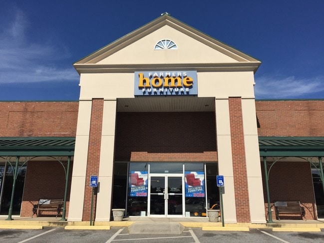
Property Record
100 N Bennett St, Forsyth, GA 31029

Save to a Folder
{{folder.Name}}
{{folder.ListingIds.length}} Properties
{{folder.ListingIds.length}} Property
Create a New Folder
Property Detail
100 N Bennett St
F35-054A
LL 182 LD 6 PARCEL 2
Stripcommercialcenter
MONROE
001
Georgia
B and X Area of moderate flood hazard, usually the area between the limits of the 100-year and 500-year floods.
1.66 AC
2025
Monroe County
2025
Atlanta
050200
Macon-Bibb County, GA
27,540 SF
NEARBY LISTINGS FOR SALE OR LEASE
DEMOGRAPHICS near 100 N Bennett St
1 mile
3 mile
5 mile
2025 Total Population
3,331
8,513
11,629
2030 Population
3,692
9,440
12,898
Pop Growth 2025-2030
+ 10.84%
+ 10.89%
+ 10.91%
Average Age
40
40
41
2025 Total Households
1,268
3,245
4,348
HH Growth 2025-2030
+ 11.28%
+ 11.28%
+ 11.32%
Median Household Inc
$71,679
$74,543
$75,019
Avg Household Size
2.40
2.50
2.50
2025 Avg HH Vehicles
2.00
2.00
2.00
Median Home Value
$286,440
$248,714
$257,980
Median Year Built
1979
1979
1984
Nearby Places
Map Layers
Map Styles
 Street
 Aerial
Layers
 Traffic
 Biking
Places
Listings with unknown addresses are not visible on the map
- Restaurants
- Banks
- Shops
- Fitness
- Groceries
SALE & LEASE HISTORY
LISTING DATE
SALE/LEASE

Sep 25, 2016
For Lease
Oct 09, 2020
For Lease
Jan 15, 2019
For Lease
Nearby Properties
Address
Land Use
TOTAL SIZE
Lot Size
Zoning
Address
Land Use
TOTAL SIZE
Lot Size
Zoning
155,109 SF
23.90 AC
Address
Land Use
TOTAL SIZE
Lot Size
Zoning
30.77 AC
002
Address
Land Use
TOTAL SIZE
Lot Size
Zoning
37,507 SF
6.17 AC
001
Address
Land Use
TOTAL SIZE
Lot Size
Zoning
53,324 SF
18.14 AC
Address
Land Use
TOTAL SIZE
Lot Size
Zoning
58,240 SF
0.51 AC
001
Address
Land Use
TOTAL SIZE
Lot Size
Zoning
1,192 SF
7.36 AC
006
Address
Land Use
TOTAL SIZE
Lot Size
Zoning
53,324 SF
18.14 AC
Address
Land Use
TOTAL SIZE
Lot Size
Zoning
0.25 AC
003
Address
Land Use
TOTAL SIZE
Lot Size
Zoning
0.11 AC
007
Address
Land Use
TOTAL SIZE
Lot Size
Zoning
40,452 SF
2 AC
Address
Land Use
TOTAL SIZE
Lot Size
Zoning
47,072 SF
2.89 AC
003
Address
Land Use
TOTAL SIZE
Lot Size
Zoning
25,753 SF
5.14 AC
003
Address
Land Use
TOTAL SIZE
Lot Size
Zoning
55,261 SF
17.91 AC
006
Address
Land Use
TOTAL SIZE
Lot Size
Zoning
0.16 AC
003
Address
Land Use
TOTAL SIZE
Lot Size
Zoning
23,096 SF
5.75 AC
003
Address
Land Use
TOTAL SIZE
Lot Size
Zoning
12,960 SF
2.70 AC
001
Address
Land Use
TOTAL SIZE
Lot Size
Zoning
7,304 SF
8.05 AC
006
Address
Land Use
TOTAL SIZE
Lot Size
Zoning
40,280 SF
3.08 AC
001
Address
Land Use
TOTAL SIZE
Lot Size
Zoning
39,132 SF
0.91 AC
Address
Land Use
TOTAL SIZE
Lot Size
Zoning
2,464 SF
10.70 AC
006
Address
Land Use
TOTAL SIZE
Lot Size
Zoning
3.02 AC
006
Address
Land Use
TOTAL SIZE
Lot Size
Zoning
50,820 SF
2.43 AC
006
Address
Land Use
TOTAL SIZE
Lot Size
Zoning
2,568 SF
10.14 AC
003
Address
Land Use
TOTAL SIZE
Lot Size
Zoning
55.20 AC
Address
Land Use
TOTAL SIZE
Lot Size
Zoning
719 SF
3.52 AC
001
Address
Land Use
TOTAL SIZE
Lot Size
Zoning
20,000 SF
9.50 AC
006
Address
Land Use
TOTAL SIZE
Lot Size
Zoning
15,628 SF
5.56 AC
001
Address
Land Use
TOTAL SIZE
Lot Size
Zoning
32,406 SF
7.64 AC
001
Address
Land Use
TOTAL SIZE
Lot Size
Zoning
76.10 AC
Address
Land Use
TOTAL SIZE
Lot Size
Zoning
0.53 AC
003
The World's #1 Commercial Real Estate Marketplace
Connect with us
© 2026 CoStar Group
The information above has been obtained from sources believed reliable. While we do not doubt its accuracy we have not verified it and make no guarantee, warranty or representation about it. It is your responsibility to independently confirm its accuracy and completeness. Any projections, opinions, assumptions, or estimates used are for example only and do not represent the current or future performance of the property. The value of this transaction to you depends on tax and other factors which should be evaluated by your tax, financial, and legal advisors. You and your advisors should conduct a careful, independent investigation of the property to determine to your satisfaction the suitability of the property for your needs.