Property Record
100 N Blettner Ave, Hanover, PA 17331


Save to a Folder
{{folder.Name}}
{{folder.ListingIds.length}} Properties
{{folder.ListingIds.length}} Property
Create a New Folder
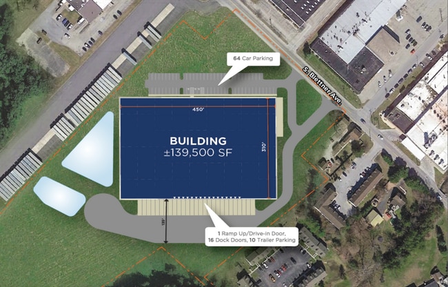
Property Detail
100 N Blettner Ave
08-L15-0060-000
ADAMS
Commercialacreage
Pennsylvania
CI
17.74 AC
AE The base floodplain where base flood elevations are provided. AE Zones are now used on new format FIRMs instead of A1-A30 Zones.
Adams County
2026
Philadelphia
2026
Gettysburg, PA
022000
NEARBY LISTINGS FOR SALE OR LEASE
DEMOGRAPHICS near 100 N Blettner Ave
1 mile
3 mile
5 mile
2025 Total Population
7,735
46,793
63,659
2030 Population
7,940
48,277
65,795
Pop Growth 2025-2030
+ 2.65%
+ 3.17%
+ 3.36%
Average Age
43
42
43
2025 Total Households
3,045
19,145
25,480
HH Growth 2025-2030
+ 2.82%
+ 3.31%
+ 3.48%
Median Household Inc
$70,021
$71,130
$75,191
Avg Household Size
2.40
2.40
2.40
2025 Avg HH Vehicles
2.00
2.00
2.00
Median Home Value
$227,388
$238,242
$250,744
Median Year Built
1958
1973
1978
Nearby Places
Map Layers
Map Styles
 Street
 Aerial
Layers
 Traffic
 Biking
Places
Listings with unknown addresses are not visible on the map
- Restaurants
- Banks
- Shops
- Fitness
- Groceries
PUBLIC TRANSPORTATION
AIRPORT
Harrisburg International
Drive
Walk
Distance
Harrisburg International
74 min
49.5 mi
Freight Ports
Port of Baltimore
Drive
Walk
Distance
Port of Baltimore
74 min
51.7 mi
Nearby Properties
Address
Land Use
TOTAL SIZE
Lot Size
Zoning
Address
Land Use
TOTAL SIZE
Lot Size
Zoning
65,738 SF
89.96 AC
RS
Address
Land Use
TOTAL SIZE
Lot Size
Zoning
35.99 AC
Address
Land Use
TOTAL SIZE
Lot Size
Zoning
2,331 SF
104.05 AC
CI
Address
Land Use
TOTAL SIZE
Lot Size
Zoning
93.98 AC
CI
Address
Land Use
TOTAL SIZE
Lot Size
Zoning
59,212 SF
38.80 AC
RS
Address
Land Use
TOTAL SIZE
Lot Size
Zoning
23,050 SF
26.70 AC
CM
Address
Land Use
TOTAL SIZE
Lot Size
Zoning
15.58 AC
SC
Address
Land Use
TOTAL SIZE
Lot Size
Zoning
109.27 AC
CI
Address
Land Use
TOTAL SIZE
Lot Size
Zoning
12.32 AC
CI
Address
Land Use
TOTAL SIZE
Lot Size
Zoning
129,869 SF
44.23 AC
ID
Address
Land Use
TOTAL SIZE
Lot Size
Zoning
190,175 SF
20.98 AC
ID
Address
Land Use
TOTAL SIZE
Lot Size
Zoning
24.39 AC
CI
Address
Land Use
TOTAL SIZE
Lot Size
Zoning
195,797 SF
20.31 AC
CM
Address
Land Use
TOTAL SIZE
Lot Size
Zoning
307,500 SF
23.24 AC
ID
Address
Land Use
TOTAL SIZE
Lot Size
Zoning
360,608 SF
46.91 AC
ID
Address
Land Use
TOTAL SIZE
Lot Size
Zoning
49,736 SF
20.73 AC
CM
Address
Land Use
TOTAL SIZE
Lot Size
Zoning
6.16 AC
CI
Address
Land Use
TOTAL SIZE
Lot Size
Zoning
137,390 SF
17.47 AC
M
Address
Land Use
TOTAL SIZE
Lot Size
Zoning
16,669 SF
1.51 AC
Address
Land Use
TOTAL SIZE
Lot Size
Zoning
207,780 SF
16.72 AC
CM
Address
Land Use
TOTAL SIZE
Lot Size
Zoning
13.23 AC
CI
Address
Land Use
TOTAL SIZE
Lot Size
Zoning
9.80 AC
CI
Address
Land Use
TOTAL SIZE
Lot Size
Zoning
13.32 AC
CI
Address
Land Use
TOTAL SIZE
Lot Size
Zoning
60,590 SF
11.04 AC
IND
Address
Land Use
TOTAL SIZE
Lot Size
Zoning
67,650 SF
7.42 AC
RS
Address
Land Use
TOTAL SIZE
Lot Size
Zoning
376,800 SF
26.23 AC
ID
Address
Land Use
TOTAL SIZE
Lot Size
Zoning
Address
Land Use
TOTAL SIZE
Lot Size
Zoning
196,848 SF
7.78 AC
RS
Address
Land Use
TOTAL SIZE
Lot Size
Zoning
183,195 SF
22.71 AC
CI
Address
Land Use
TOTAL SIZE
Lot Size
Zoning
9.64 AC
CI
The World's #1 Commercial Real Estate Marketplace
Connect with us
© 2026 CoStar Group
The information above has been obtained from sources believed reliable. While we do not doubt its accuracy we have not verified it and make no guarantee, warranty or representation about it. It is your responsibility to independently confirm its accuracy and completeness. Any projections, opinions, assumptions, or estimates used are for example only and do not represent the current or future performance of the property. The value of this transaction to you depends on tax and other factors which should be evaluated by your tax, financial, and legal advisors. You and your advisors should conduct a careful, independent investigation of the property to determine to your satisfaction the suitability of the property for your needs.