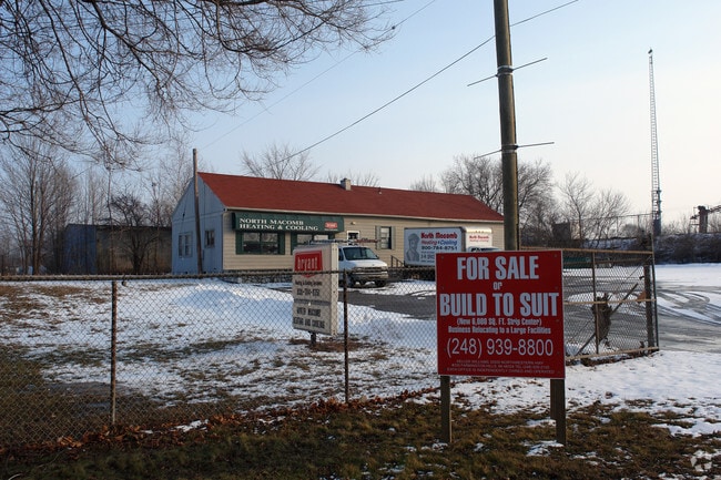
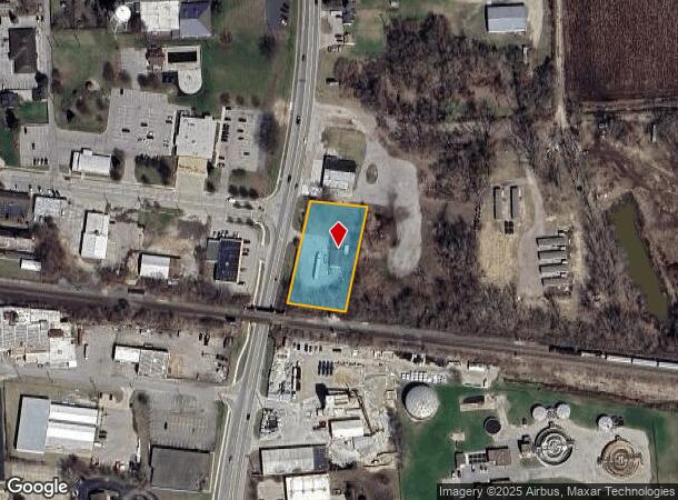
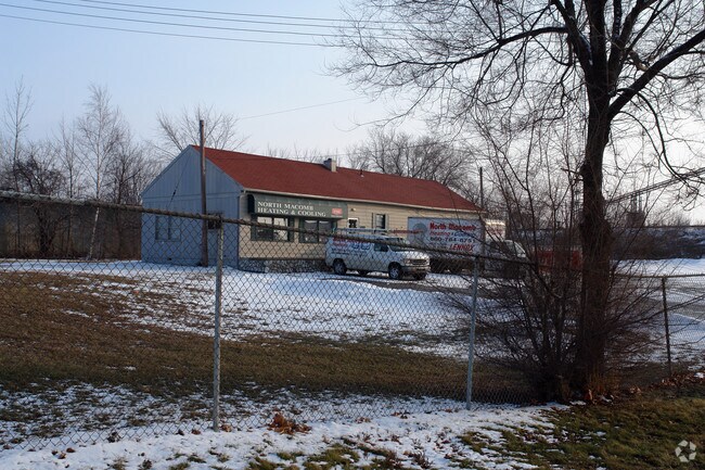
Property Record
100 N Cedar St, Imlay City, MI 48444
NEARBY LISTINGS FOR SALE OR LEASE
Property Detail
100 N Cedar St
I19-81-900-000-00
COMM AT A POINT OF INTERSECTION E. LINE OF M-53 OF AN EAETERLY OF TH N. LINE OF THIRD ST IN CITY OF IMLAY CITY; TH S ON THE
Officebuilding
Lapeer
A
Michigan
26087C0314E
0.91 AC
2024
St Clair & Lapeer Counties
2025
Detroit
339500
Detroit-Warren-Dearborn, MI
1,976 SF
DEMOGRAPHICS near 100 N Cedar St
1 Mile
3 Mile
5 Mile
2024 Total Population
2,933
6,695
10,915
2029 Population
2,949
6,703
10,909
Pop Growth 2024-2029
+ 0.55%
+ 0.12%
(0.05%)
Average Age
39
40
41
2024 Total Households
1,215
2,624
4,208
HH Growth 2024-2029
+ 0.49%
+ 0.11%
(0.07%)
Median Household Inc
$37,176
$55,000
$68,566
Avg Household Size
2.40
2.50
2.60
2024 Avg HH Vehicles
2.00
2.00
2.00
Median Home Value
$129,329
$168,723
$198,318
Median Year Built
1970
1977
1980
Nearby Places
Map Layers
Map Styles
 Street
 Aerial
- Restaurants
- Banks
- Shops
- Fitness
- Groceries
PUBLIC TRANSPORTATION
AIRPORT
Bishop International
DRIVE
WALK
Distance
Bishop International
55 min
42.0 mi
SALE & LEASE HISTORY
LISTING DATE
SALE/LEASE

Sep 25, 2016
For Lease
Mar 01, 2018
For Lease
Jul 10, 2019
For Lease
Nearby Properties
Address
Land Use
TOTAL SIZE
Lot Size
Zoning
Address
Land Use
TOTAL SIZE
Lot Size
Zoning
124,784 SF
15.68 AC
B-3 GEN
Address
Land Use
TOTAL SIZE
Lot Size
Zoning
189,953 SF
15.30 AC
RM-1 MU
Address
Land Use
TOTAL SIZE
Lot Size
Zoning
155,289 SF
25 AC
I-1 LIG
Address
Land Use
TOTAL SIZE
Lot Size
Zoning
326,044 SF
14 AC
I-2 HEA
Address
Land Use
TOTAL SIZE
Lot Size
Zoning
33.46 AC
RM-1 MU
Address
Land Use
TOTAL SIZE
Lot Size
Zoning
104,973 SF
27.31 AC
I-1 PUD
Address
Land Use
TOTAL SIZE
Lot Size
Zoning
18,158 SF
9.76 AC
B-3 GEN
Address
Land Use
TOTAL SIZE
Lot Size
Zoning
106,337 SF
80 AC
AG
Address
Land Use
TOTAL SIZE
Lot Size
Zoning
151,640 SF
11.82 AC
I-1 LIG
Address
Land Use
TOTAL SIZE
Lot Size
Zoning
55,279 SF
5.84 AC
B-3 GEN
Address
Land Use
TOTAL SIZE
Lot Size
Zoning
3,980 SF
3.68 AC
B-3 GEN
Address
Land Use
TOTAL SIZE
Lot Size
Zoning
59,520 SF
5.60 AC
I-1 LIG
Address
Land Use
TOTAL SIZE
Lot Size
Zoning
59,624 SF
6.47 AC
B-3 GEN
Address
Land Use
TOTAL SIZE
Lot Size
Zoning
33,808 SF
6.43 AC
B-3 GEN
Address
Land Use
TOTAL SIZE
Lot Size
Zoning
72,502 SF
4.59 AC
I-1 LIG
Address
Land Use
TOTAL SIZE
Lot Size
Zoning
43,144 SF
4.35 AC
R-1 960
Address
Land Use
TOTAL SIZE
Lot Size
Zoning
17,808 SF
2.87 AC
B-3 GEN
Address
Land Use
TOTAL SIZE
Lot Size
Zoning
22,537 SF
6.84 AC
R-1 960
Address
Land Use
TOTAL SIZE
Lot Size
Zoning
3,706 SF
231.68 AC
AG
Address
Land Use
TOTAL SIZE
Lot Size
Zoning
50,460 SF
4 AC
I-1 LIG
Address
Land Use
TOTAL SIZE
Lot Size
Zoning
8,883 SF
1.75 AC
R-1 960
Address
Land Use
TOTAL SIZE
Lot Size
Zoning
40,000 SF
3 AC
I-1 LIG
Address
Land Use
TOTAL SIZE
Lot Size
Zoning
25,781 SF
2.72 AC
B-3 GEN
Address
Land Use
TOTAL SIZE
Lot Size
Zoning
30,000 SF
I-1 LIG
Address
Land Use
TOTAL SIZE
Lot Size
Zoning
5,125 SF
1.51 AC
R-1 960
Address
Land Use
TOTAL SIZE
Lot Size
Zoning
42,940 SF
3.07 AC
I-1 LIG
Address
Land Use
TOTAL SIZE
Lot Size
Zoning
5,956 SF
1.31 AC
R-1 960
Address
Land Use
TOTAL SIZE
Lot Size
Zoning
189.21 AC
AG
Address
Land Use
TOTAL SIZE
Lot Size
Zoning
40,837 SF
2.47 AC
R-1 960
Address
Land Use
TOTAL SIZE
Lot Size
Zoning
28,858 SF
38 AC
I-1 LIG
The World's #1 Commercial Real Estate Marketplace
Connect with us
© 2025 CoStar Group
The information above has been obtained from sources believed reliable. While we do not doubt its accuracy we have not verified it and make no guarantee, warranty or representation about it. It is your responsibility to independently confirm its accuracy and completeness. Any projections, opinions, assumptions, or estimates used are for example only and do not represent the current or future performance of the property. The value of this transaction to you depends on tax and other factors which should be evaluated by your tax, financial, and legal advisors. You and your advisors should conduct a careful, independent investigation of the property to determine to your satisfaction the suitability of the property for your needs.