Property Record
100 N Evans Ave, Raymore, MO 64083

Save to a Folder
{{folder.Name}}
{{folder.ListingIds.length}} Properties
{{folder.ListingIds.length}} Property
Create a New Folder
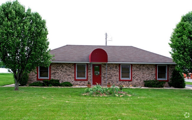
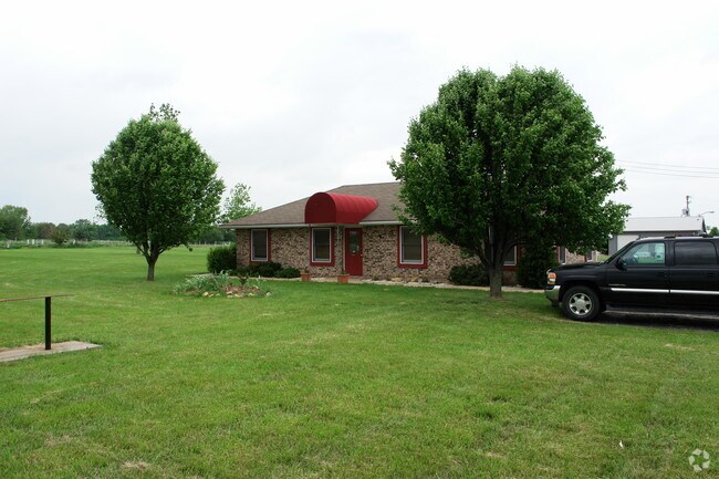
Property Detail
100 N Evans Ave
Kansas City, MO-KS
RAYMORE DEV PARK-RESURVEY PT TR 1 LOT 1&S25LT2
2240103
Cass
Officebuilding
Missouri
B and X Area of moderate flood hazard, usually the area between the limits of the 100-year and 500-year floods.
1
2024
0.94 AC
2025
Cass County
060309
Kansas City
1,152 SF
NEARBY LISTINGS FOR SALE OR LEASE
DEMOGRAPHICS near 100 N Evans Ave
1 mile
3 mile
5 mile
2025 Total Population
5,159
27,822
64,764
2030 Population
5,430
29,190
67,663
Pop Growth 2025-2030
+ 5.25%
+ 4.92%
+ 4.48%
Average Age
41
41
40
2025 Total Households
1,983
10,259
24,062
HH Growth 2025-2030
+ 5.50%
+ 5.05%
+ 4.69%
Median Household Inc
$74,367
$96,912
$93,969
Avg Household Size
2.50
2.70
2.60
2025 Avg HH Vehicles
2.00
2.00
2.00
Median Home Value
$245,514
$328,258
$333,598
Median Year Built
1991
2000
1999
Nearby Places
Map Layers
Map Styles
 Street
 Aerial
Layers
 Traffic
 Biking
Places
Listings with unknown addresses are not visible on the map
- Restaurants
- Banks
- Shops
- Fitness
- Groceries
SALE & LEASE HISTORY
LISTING DATE
SALE/LEASE

Nov 20, 2017
For Lease
Jun 03, 2023
For Lease
Nearby Properties
Address
Land Use
TOTAL SIZE
Lot Size
Zoning
Address
Land Use
TOTAL SIZE
Lot Size
Zoning
28.36 AC
Address
Land Use
TOTAL SIZE
Lot Size
Zoning
4,954 SF
23.93 AC
Address
Land Use
TOTAL SIZE
Lot Size
Zoning
15.22 AC
Address
Land Use
TOTAL SIZE
Lot Size
Zoning
3.31 AC
Address
Land Use
TOTAL SIZE
Lot Size
Zoning
2.23 AC
Address
Land Use
TOTAL SIZE
Lot Size
Zoning
50,121 SF
2.98 AC
Address
Land Use
TOTAL SIZE
Lot Size
Zoning
80,456 SF
8.23 AC
Address
Land Use
TOTAL SIZE
Lot Size
Zoning
2.18 AC
Address
Land Use
TOTAL SIZE
Lot Size
Zoning
181,400 SF
12.23 AC
Address
Land Use
TOTAL SIZE
Lot Size
Zoning
1.94 AC
Address
Land Use
TOTAL SIZE
Lot Size
Zoning
1.76 AC
Address
Land Use
TOTAL SIZE
Lot Size
Zoning
5.46 AC
Address
Land Use
TOTAL SIZE
Lot Size
Zoning
594,769 SF
18.43 AC
Address
Land Use
TOTAL SIZE
Lot Size
Zoning
25,484 SF
2.13 AC
Address
Land Use
TOTAL SIZE
Lot Size
Zoning
611,460 SF
23.70 AC
Address
Land Use
TOTAL SIZE
Lot Size
Zoning
137,544 SF
11.36 AC
Address
Land Use
TOTAL SIZE
Lot Size
Zoning
137,824 SF
13.62 AC
Address
Land Use
TOTAL SIZE
Lot Size
Zoning
Address
Land Use
TOTAL SIZE
Lot Size
Zoning
19,714 SF
8.40 AC
Address
Land Use
TOTAL SIZE
Lot Size
Zoning
Address
Land Use
TOTAL SIZE
Lot Size
Zoning
20,980 SF
3.06 AC
Address
Land Use
TOTAL SIZE
Lot Size
Zoning
14,466 SF
1.44 AC
Address
Land Use
TOTAL SIZE
Lot Size
Zoning
8,800 SF
1.26 AC
Address
Land Use
TOTAL SIZE
Lot Size
Zoning
103,066 SF
4.86 AC
Address
Land Use
TOTAL SIZE
Lot Size
Zoning
15,336 SF
3.06 AC
Address
Land Use
TOTAL SIZE
Lot Size
Zoning
116,250 SF
6.71 AC
Address
Land Use
TOTAL SIZE
Lot Size
Zoning
218,689 SF
10.37 AC
Address
Land Use
TOTAL SIZE
Lot Size
Zoning
8,499 SF
1.65 AC
Address
Land Use
TOTAL SIZE
Lot Size
Zoning
18,946 SF
3.90 AC
Address
Land Use
TOTAL SIZE
Lot Size
Zoning
11,304 SF
3.50 AC
The World's #1 Commercial Real Estate Marketplace
Connect with us
© 2026 CoStar Group
The information above has been obtained from sources believed reliable. While we do not doubt its accuracy we have not verified it and make no guarantee, warranty or representation about it. It is your responsibility to independently confirm its accuracy and completeness. Any projections, opinions, assumptions, or estimates used are for example only and do not represent the current or future performance of the property. The value of this transaction to you depends on tax and other factors which should be evaluated by your tax, financial, and legal advisors. You and your advisors should conduct a careful, independent investigation of the property to determine to your satisfaction the suitability of the property for your needs.